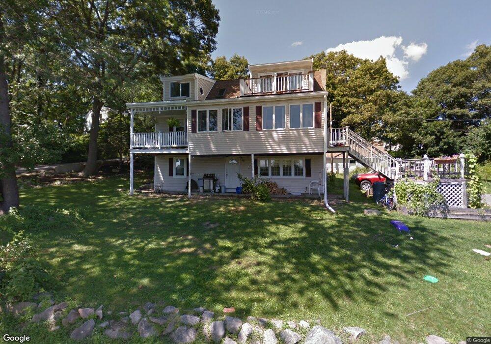
12 Doanne Rd Gloucester, MA 01930
Riverview NeighborhoodEstimated Value: $1,013,000 - $1,180,282
4
Beds
2
Baths
1,864
Sq Ft
$599/Sq Ft
Est. Value
About This Home
This home is located at 12 Doanne Rd, Gloucester, MA 01930 and is currently estimated at $1,115,821, approximately $598 per square foot. 12 Doanne Rd is a home located in Essex County with nearby schools including Beeman Memorial, Ralph B O'maley Middle School, and Gloucester High School.
Ownership History
Date
Name
Owned For
Owner Type
Purchase Details
Closed on
Aug 4, 2003
Sold by
Baptista Catherine A and Baptista Richard A
Bought by
Flynn Raymond Gerald and Flynn Jessica P
Current Estimated Value
Home Financials for this Owner
Home Financials are based on the most recent Mortgage that was taken out on this home.
Original Mortgage
$300,000
Interest Rate
5.28%
Mortgage Type
Purchase Money Mortgage
Create a Home Valuation Report for This Property
The Home Valuation Report is an in-depth analysis detailing your home's value as well as a comparison with similar homes in the area
Home Values in the Area
Average Home Value in this Area
Purchase History
| Date | Buyer | Sale Price | Title Company |
|---|---|---|---|
| Flynn Raymond Gerald | $525,000 | -- |
Source: Public Records
Mortgage History
| Date | Status | Borrower | Loan Amount |
|---|---|---|---|
| Open | Flynn Raymond Gerald | $310,000 | |
| Closed | Flynn Raymond Gerald | $300,000 | |
| Previous Owner | Flynn Raymond Gerald | $65,000 |
Source: Public Records
Tax History
| Year | Tax Paid | Tax Assessment Tax Assessment Total Assessment is a certain percentage of the fair market value that is determined by local assessors to be the total taxable value of land and additions on the property. | Land | Improvement |
|---|---|---|---|---|
| 2025 | $11,237 | $1,156,100 | $753,900 | $402,200 |
| 2024 | $11,114 | $1,142,200 | $718,000 | $424,200 |
| 2023 | $10,498 | $991,300 | $612,900 | $378,400 |
| 2022 | $9,795 | $835,000 | $533,000 | $302,000 |
| 2021 | $9,683 | $778,400 | $484,100 | $294,300 |
| 2020 | $9,421 | $764,100 | $484,100 | $280,000 |
| 2019 | $9,233 | $727,600 | $461,600 | $266,000 |
| 2018 | $9,073 | $701,700 | $450,400 | $251,300 |
| 2017 | $8,767 | $664,700 | $429,200 | $235,500 |
| 2016 | $8,747 | $642,700 | $410,500 | $232,200 |
| 2015 | $8,412 | $616,300 | $401,100 | $215,200 |
Source: Public Records
Map
Nearby Homes
- 2 Breezy Point Rd
- 13 Honeysuckle Rd
- 3 Deacon Farm Ln
- 31 Echo Ave
- 672 Washington St
- 167 Atlantic St
- 178 Atlantic St
- 226 Atlantic St
- 3 Rockland St
- 13 Mystic Ave
- 8 Mystic Ave
- 6 Monroe Ct
- 98 Maplewood Ave
- 136 Leonard St
- 9 Cleveland Place
- 12 Arthur St
- 40 Sargent St
- 19 Trask St Unit 2
- 15 Harvard St
- 50 Warner St
Your Personal Tour Guide
Ask me questions while you tour the home.