P
Seller's Agent in 2025
Peggy Patenaude
William Raveis R.E. & Home Services
(978) 804-0811
25 in this area
203 Total Sales


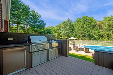
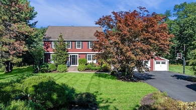

OPEN HOUSE SUNDAY CANCELLED. OFFER ACCEPTED. IMPRESSIVE home, perfectly located at the end of a cul-de-sac in prestigious Andover Country Club - a neighborhood of cul-de-sacs. Enjoy one of the most stunning yards in Andover w/ a fabulous composite deck, dream fire-pit, outdoor kitchen & expansive yard w/ in-ground pool. A major renovation/addition brought a top-of-the-line Kitchen w/white cabinets, walnut center island, quartz counters, high-end SS appliances, wet bar & walk-in pantry. All bathrooms have been completely renovated w/ a modern flair. The luxurious primary suite bathrm features a cathedral ceiling, hickory double vanity, soaking tub, huge tile shower, radiant heated floor, & even a towel warmer. Stunning new Laundry rm too! Plus, that MUDROOM you've always wanted w/ cubbies & benches. Family Rm & Great Rm provide casual space. Home Office is great for working remote. The fin LL offers space for a gym, playrm, guest area & yet another new full bath. Conveniently located!
Last Agent to Sell the Property
William Raveis R.E. & Home Services Listed on: 09/24/2025

| Date | Type | Sale Price | Title Company |
|---|---|---|---|
| Quit Claim Deed | $1,975,000 | -- | |
| Deed | $800,000 | -- | |
| Deed | $800,000 | -- | |
| Deed | $800,000 | -- | |
| Deed | $432,500 | -- | |
| Deed | $432,500 | -- |
| Date | Status | Loan Amount | Loan Type |
|---|---|---|---|
| Open | $675,000 | Purchase Money Mortgage | |
| Previous Owner | $400,000 | No Value Available | |
| Previous Owner | $208,040 | No Value Available |
| Date | Event | Price | List to Sale | Price per Sq Ft |
|---|---|---|---|---|
| 10/23/2025 10/23/25 | Sold | $1,975,000 | +4.6% | $402 / Sq Ft |
| 09/27/2025 09/27/25 | Pending | -- | -- | -- |
| 09/24/2025 09/24/25 | For Sale | $1,888,000 | -- | $384 / Sq Ft |
| Year | Tax Paid | Tax Assessment Tax Assessment Total Assessment is a certain percentage of the fair market value that is determined by local assessors to be the total taxable value of land and additions on the property. | Land | Improvement |
|---|---|---|---|---|
| 2024 | $17,002 | $1,320,000 | $620,600 | $699,400 |
| 2023 | $15,926 | $1,165,900 | $530,400 | $635,500 |
| 2022 | $14,815 | $1,014,700 | $477,800 | $536,900 |
| 2021 | $14,243 | $931,500 | $434,500 | $497,000 |
| 2020 | $13,871 | $924,100 | $434,500 | $489,600 |
| 2019 | $13,558 | $887,900 | $404,900 | $483,000 |
| 2018 | $13,145 | $840,500 | $393,000 | $447,500 |
| 2017 | $12,637 | $832,500 | $385,300 | $447,200 |
| 2016 | $12,390 | $836,000 | $385,300 | $450,700 |
| 2015 | $12,177 | $813,400 | $385,300 | $428,100 |
P
Seller's Agent in 2025
Peggy Patenaude
William Raveis R.E. & Home Services
(978) 804-0811
25 in this area
203 Total Sales
Buyer's Agent in 2025
Kim Covino
Compass
(781) 249-3854
1 in this area
433 Total Sales
Source: MLS Property Information Network (MLS PIN)
MLS Number: 73434809
APN: ANDO-000070-000060
Disclaimer: Certain information contained herein is derived from information provided by parties other than Homes.com. All information provided is deemed reliable, but is not guaranteed to be accurate and should be independently verified.
![]() The property listing data and information, or the Images, set forth herein were provided to MLS Property Information Network, Inc. from third party sources, including sellers, lessors and public records, and were compiled by MLS Property Information Network, Inc. The property listing data and information, and the Images, are for the personal, non-commercial use of consumers having a good faith interest in purchasing or leasing listed properties of the type displayed to them and may not be used for any purpose other than to identify prospective properties which such consumers may have a good faith interest in purchasing or leasing. MLS Property Information Network, Inc. and its subscribers disclaim any and all representations and warranties as to the accuracy of the property listing data and information, or as to the accuracy of any of the Images, set forth herein.
The property listing data and information, or the Images, set forth herein were provided to MLS Property Information Network, Inc. from third party sources, including sellers, lessors and public records, and were compiled by MLS Property Information Network, Inc. The property listing data and information, and the Images, are for the personal, non-commercial use of consumers having a good faith interest in purchasing or leasing listed properties of the type displayed to them and may not be used for any purpose other than to identify prospective properties which such consumers may have a good faith interest in purchasing or leasing. MLS Property Information Network, Inc. and its subscribers disclaim any and all representations and warranties as to the accuracy of the property listing data and information, or as to the accuracy of any of the Images, set forth herein.
Ask me questions while you tour the home.