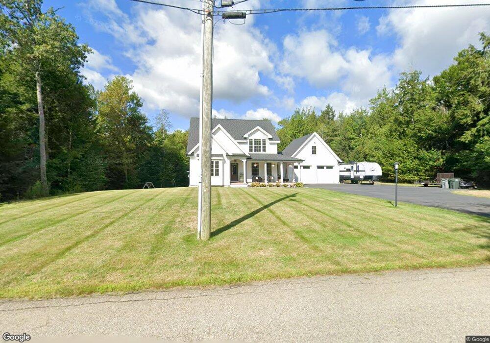
12 Michael Dr Rindge, NH 03461
Estimated Value: $516,000 - $643,997
3
Beds
3
Baths
2,543
Sq Ft
$229/Sq Ft
Est. Value
About This Home
This home is located at 12 Michael Dr, Rindge, NH 03461 and is currently estimated at $582,499, approximately $229 per square foot. 12 Michael Dr is a home with nearby schools including Rindge Memorial School, Conant Middle High School, and Conant High School.
Ownership History
Date
Name
Owned For
Owner Type
Purchase Details
Closed on
Sep 5, 2017
Sold by
Sikkila Tyler E and Sikkila Bianca K
Bought by
Aho Ethan and Aho Simone
Current Estimated Value
Create a Home Valuation Report for This Property
The Home Valuation Report is an in-depth analysis detailing your home's value as well as a comparison with similar homes in the area
Home Values in the Area
Average Home Value in this Area
Purchase History
| Date | Buyer | Sale Price | Title Company |
|---|---|---|---|
| Aho Ethan | -- | -- |
Source: Public Records
Tax History Compared to Growth
Tax History
| Year | Tax Paid | Tax Assessment Tax Assessment Total Assessment is a certain percentage of the fair market value that is determined by local assessors to be the total taxable value of land and additions on the property. | Land | Improvement |
|---|---|---|---|---|
| 2024 | $8,767 | $346,400 | $56,200 | $290,200 |
| 2023 | $8,606 | $343,700 | $56,200 | $287,500 |
| 2022 | $7,915 | $343,700 | $56,200 | $287,500 |
| 2021 | $7,785 | $343,700 | $56,200 | $287,500 |
| 2020 | $7,716 | $343,700 | $56,200 | $287,500 |
| 2019 | $7,309 | $263,300 | $46,700 | $216,600 |
| 2018 | $8,676 | $315,500 | $46,700 | $268,800 |
| 2017 | $5,514 | $202,800 | $46,700 | $156,100 |
| 2016 | $1,303 | $46,700 | $46,700 | $0 |
| 2015 | $1,302 | $46,700 | $46,700 | $0 |
| 2014 | $1,791 | $68,800 | $68,800 | $0 |
| 2013 | $16 | $628 | $628 | $0 |
Source: Public Records
Map
Nearby Homes
- 46 Swan Point Rd
- 28 Wellington Rd
- 110 Red Gate Ln
- 7 Emerson Dr
- Lot 4 Saybrook Dr
- 64 Old Ashburnham Rd
- 19 Monomonac Terrace
- 11 Mark St
- Lot 1 Saybrook Dr
- Lot 2 Saybrook Dr
- Lot 15-0 Saybrook Dr
- Lot 14 Saybrook Dr
- 16 2nd St
- 40 Maple Dr
- 35 Hillside Dr
- 634 Old New Ipswich Rd
- 20 W Main St
- 714 Old New Ipswich Rd
- 703 Old New Ipswich Rd
- 31 Willow Ln
- 22 Michael Dr
- 83-4 Michael Dr
- 32 Atlantic Dr
- 0 Michael Dr
- 0 Michael Dr Unit 4003931
- 17 Michael Dr
- 34 Michael Dr
- 26 Atlantic Dr
- 27 Michael Dr
- 18 Atlantic Dr
- 33 Michael Dr
- 27 Atlantic Dr
- 31 Michael Dr
- 44 Michael Dr
- 46 Michael Dr
- 35 Michael Dr
- 12 Atlantic Dr
- 9 Converseville Rd
- 8 Atlantic Dr
- 45 Scotts Ln