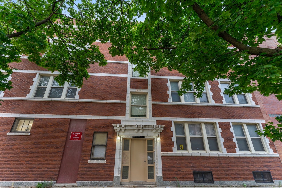
12 N Mayfield Ave Unit 3 Chicago, IL 60644
Austin NeighborhoodEstimated payment $1,105/month
Highlights
- Wood Flooring
- Laundry Room
- Dining Room
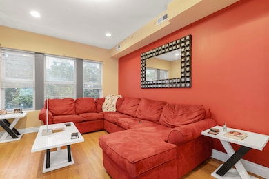
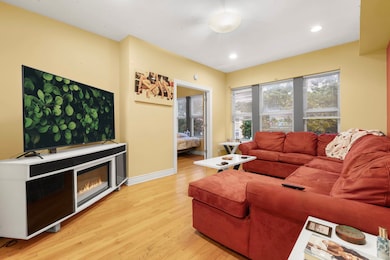
- Living Room
- Central Air
- Family Room
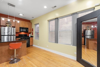
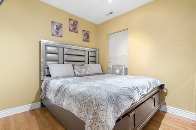
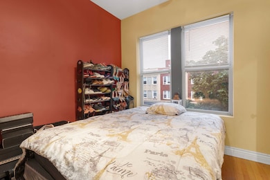
About This Home
This beautifully maintained condo offers the perfect blend of comfort, convenience, and investment potential. Whether you're a first-time buyer looking for a stylish and affordable starter home or an investor seeking steady rental income, this property checks every box. Its modern design, efficient layout, and prime location near shopping, dining, and public transit make it a highly desirable space for residents and tenants alike. With low maintenance costs and strong rental demand in the area, this condo is not just a place to live-it's a smart investment in your future.
Listing Agent
@properties Christie's International Real Estate License #475183111 Listed on: 11/03/2025

Property Details
Home Type
- Condominium
Est. Annual Taxes
- $1,500
HOA Fees
- $320 Monthly HOA Fees
Home Design
- Entry on the 3rd floor
- Brick Exterior Construction
Interior Spaces
- 1,000 Sq Ft Home
- 3-Story Property
- Family Room
- Living Room
- Dining Room
- Wood Flooring
- Laundry Room
Bedrooms and Bathrooms
- 2 Bedrooms
- 2 Potential Bedrooms
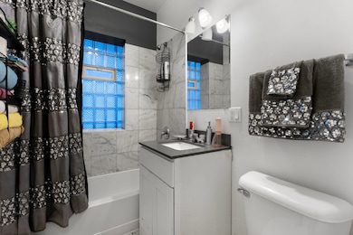
- 1 Full Bathroom
Utilities
- Central Air
- Heating System Uses Natural Gas
- Lake Michigan Water
Community Details
Overview
- Association fees include water, insurance, lawn care
- 6 Units
Pet Policy
- Dogs and Cats Allowed
Map
Home Values in the Area
Average Home Value in this Area
Tax History
| Year | Tax Paid | Tax Assessment Tax Assessment Total Assessment is a certain percentage of the fair market value that is determined by local assessors to be the total taxable value of land and additions on the property. | Land | Improvement |
|---|---|---|---|---|
| 2024 | $1,779 | $11,049 | $772 | $10,277 |
| 2023 | $1,735 | $8,436 | $547 | $7,889 |
| 2022 | $1,735 | $8,436 | $547 | $7,889 |
| 2021 | $1,696 | $8,434 | $546 | $7,888 |
| 2020 | $2,320 | $10,416 | $546 | $9,870 |
| 2019 | $2,616 | $13,021 | $546 | $12,475 |
| 2018 | $3,215 | $16,276 | $546 | $15,730 |
| 2017 | $1,815 | $8,433 | $482 | $7,951 |
| 2016 | $1,689 | $8,433 | $482 | $7,951 |
| 2015 | $1,545 | $8,433 | $482 | $7,951 |
| 2014 | $1,482 | $7,990 | $346 | $7,644 |
| 2013 | $1,453 | $7,990 | $346 | $7,644 |
Property History
| Date | Event | Price | List to Sale | Price per Sq Ft |
|---|---|---|---|---|
| 11/22/2025 11/22/25 | Price Changed | $125,000 | -3.8% | $125 / Sq Ft |
| 11/03/2025 11/03/25 | For Sale | $130,000 | -- | $130 / Sq Ft |
Purchase History
| Date | Type | Sale Price | Title Company |
|---|---|---|---|
| Special Warranty Deed | $80,000 | First American Title |
Mortgage History
| Date | Status | Loan Amount | Loan Type |
|---|---|---|---|
| Open | $78,452 | FHA |
Source: Midwest Real Estate Data (MRED)
MLS Number: 12507025
APN: 16-08-419-042-1007
Disclaimer: Certain information contained herein is derived from information provided by parties other than Homes.com. All information provided is deemed reliable, but is not guaranteed to be accurate and should be independently verified.
![]() Based on information submitted to the MLS GRID. All data is obtained from various sources and may not have been verified by broker or MLS GRID. Supplied Open House Information is subject to change without notice. All information should be independently reviewed and verified for accuracy. Properties may or may not be listed by the office/agent presenting the information. Some IDX listings have been excluded from this website.
Based on information submitted to the MLS GRID. All data is obtained from various sources and may not have been verified by broker or MLS GRID. Supplied Open House Information is subject to change without notice. All information should be independently reviewed and verified for accuracy. Properties may or may not be listed by the office/agent presenting the information. Some IDX listings have been excluded from this website.
The Digital Millennium Copyright Act of 1998, 17 U.S.C. § 512 (the “DMCA”) provides recourse for copyright owners who believe that material appearing on the Internet infringes their rights under U.S. copyright law. If you believe in good faith that any content or material made available in connection with our website or services infringes your copyright, you (or your agent) may send us a notice requesting that the content or material be removed, or access to it blocked.
Notices must be sent in writing by email to DMCAnotice@MLSGrid.com.
The DMCA requires that your notice of alleged copyright infringement include the following information:
(1) description of the copyrighted work that is the subject of claimed infringement;
(2) description of the alleged infringing content and information sufficient to permit us to locate the content;
(3) contact information for you, including your address, telephone number and email address;
(4) a statement by you that you have a good faith belief that the content in the manner complained of is not authorized by the copyright owner, or its agent, or by the operation of any law;
(5) a statement by you, signed under penalty of perjury, that the information in the notification is accurate and that you have the authority to enforce the copyrights that are claimed to be infringed; and
(6) a physical or electronic signature of the copyright owner or a person authorized to act on the copyright owner’s behalf. Failure to include all of the above information may result in the delay of the processing of your complaint.
- 5902 W Madison St Unit 3
- 35 N Mayfield Ave
- 32 S Menard Ave
- 43 N Menard Ave
- 22 S Austin Blvd
- 129 N Mason Ave Unit 105
- 514 S Humphrey Ave
- 128 N Menard Ave
- 19 S Waller Ave
- 208 S Austin Blvd
- 7639 W Jackson Blvd Unit 1E
- 207 N Austin Blvd
- 227-229 N Menard Ave
- 5815 W Fulton St
- 426 S Lombard Ave Unit 205
- 433 S Lombard Ave Unit 33
- 612 S Lombard Ave
- 316 N Austin Blvd
- 617 S Lombard Ave
- 222 Washington Blvd Unit P14
- 5836 W Madison St
- 35 N Mayfield Ave Unit 1
- 35 N Mayfield Ave Unit 2
- 38 N Menard Ave Unit 3A
- 5957 W Madison St
- 113 S Mason Ave Unit ID1305335P
- 121 N Menard Ave Unit 2
- 148 N Mason Ave Unit 3A
- 504 Lyman Ave Unit 201
- 22 N Parkside Ave Unit G
- 22 N Parkside Ave Unit 1
- 544 Lyman Ave
- 5645-5657 W Washington Blvd Unit 5647-2
- 5645-5657 W Washington Blvd Unit 5657-3N
- 5647 W Washington Blvd Unit 2
- 300 S Austin Blvd Unit 2
- 208 N Waller Ave Unit 2
- 415-425 S Taylor Ave
- 207 N Parkside Ave Unit S
- 207 N Parkside Ave Unit 3N