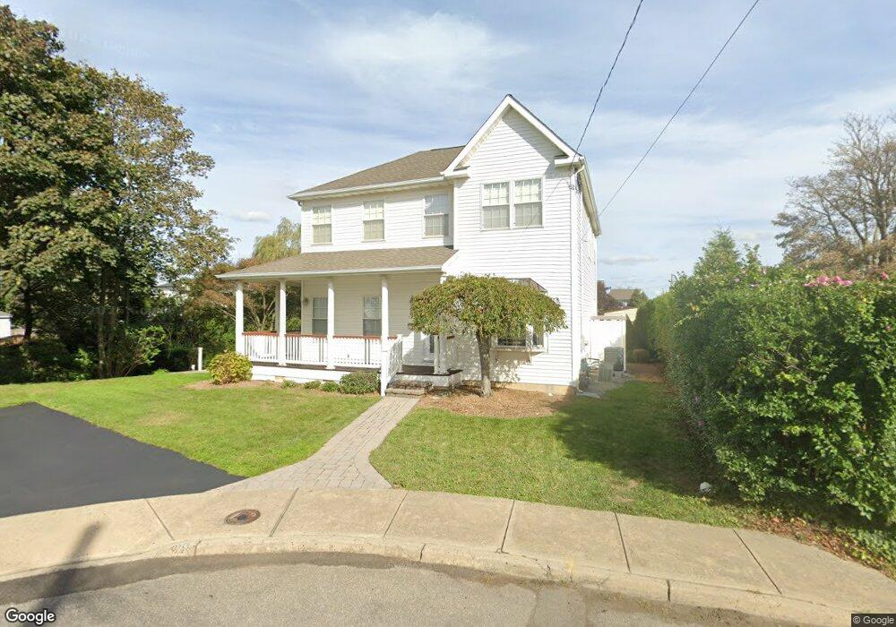
12 Nesto Terrace Long Branch, NJ 07740
Estimated Value: $740,033 - $1,212,000
3
Beds
2
Baths
1,938
Sq Ft
$508/Sq Ft
Est. Value
About This Home
This home is located at 12 Nesto Terrace, Long Branch, NJ 07740 and is currently estimated at $985,258, approximately $508 per square foot. 12 Nesto Terrace is a home located in Monmouth County with nearby schools including Long Branch High School and Holy Trinity School.
Ownership History
Date
Name
Owned For
Owner Type
Purchase Details
Closed on
Apr 5, 2010
Sold by
Mccarthy Kevin M
Bought by
Decicco Annette and Brozyna Diane
Current Estimated Value
Purchase Details
Closed on
Jun 5, 2006
Sold by
Meyer Jonathan
Bought by
Mccarthy Kevin M
Home Financials for this Owner
Home Financials are based on the most recent Mortgage that was taken out on this home.
Original Mortgage
$484,000
Interest Rate
6.59%
Mortgage Type
Purchase Money Mortgage
Purchase Details
Closed on
Jul 21, 2005
Sold by
Meyer Jonathan
Bought by
Meyer Jonathan and Meyer Judith
Home Financials for this Owner
Home Financials are based on the most recent Mortgage that was taken out on this home.
Original Mortgage
$312,000
Interest Rate
5.92%
Mortgage Type
Purchase Money Mortgage
Create a Home Valuation Report for This Property
The Home Valuation Report is an in-depth analysis detailing your home's value as well as a comparison with similar homes in the area
Home Values in the Area
Average Home Value in this Area
Purchase History
| Date | Buyer | Sale Price | Title Company |
|---|---|---|---|
| Decicco Annette | $557,000 | Associated Title Agency | |
| Mccarthy Kevin M | $605,000 | -- | |
| Meyer Jonathan | -- | -- |
Source: Public Records
Mortgage History
| Date | Status | Borrower | Loan Amount |
|---|---|---|---|
| Previous Owner | Mccarthy Kevin M | $484,000 | |
| Previous Owner | Meyer Jonathan | $312,000 |
Source: Public Records
Tax History Compared to Growth
Tax History
| Year | Tax Paid | Tax Assessment Tax Assessment Total Assessment is a certain percentage of the fair market value that is determined by local assessors to be the total taxable value of land and additions on the property. | Land | Improvement |
|---|---|---|---|---|
| 2025 | $9,280 | $648,900 | $239,900 | $409,000 |
| 2024 | $8,546 | $603,800 | $209,900 | $393,900 |
| 2023 | $8,546 | $550,300 | $169,900 | $380,400 |
| 2022 | $8,804 | $477,600 | $134,900 | $342,700 |
| 2021 | $8,804 | $440,000 | $115,900 | $324,100 |
| 2020 | $9,211 | $440,700 | $114,900 | $325,800 |
| 2019 | $8,805 | $418,900 | $104,900 | $314,000 |
| 2018 | $8,809 | $416,700 | $96,900 | $319,800 |
| 2017 | $8,285 | $402,000 | $84,900 | $317,100 |
| 2016 | $8,126 | $402,100 | $89,900 | $312,200 |
| 2015 | $7,946 | $356,800 | $60,300 | $296,500 |
| 2014 | $7,393 | $349,900 | $67,500 | $282,400 |
Source: Public Records
Map
Nearby Homes
- 55 Melrose Terrace Unit 209
- 55 Melrose Terrace Unit 112
- 30 Melrose Terrace Unit 209
- 30 Melrose Terrace Unit 303
- 15 Morris Ave Unit 206
- 15 Morris Ave Unit 618
- 15 Morris Ave Unit 202
- 15 Morris Ave Unit 505
- 20 Melrose Terrace Unit 202
- 20 Melrose Terrace Unit 408
- 20 Melrose Terrace Unit 305
- 166 Franklin Ave Unit 8
- 103 Franklin Ave
- 61 Pavilion Ave
- 150 Franklin Ave Unit 5
- 152 Franklin Ave
- 158 Franklin Ave
- 170 Franklin Ave
- 167 Chelsea Ave
- 143 Stokes Place