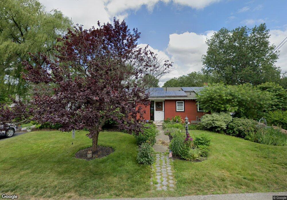
12 Newton St Auburn, MA 01501
Pakachoag NeighborhoodEstimated Value: $380,000 - $487,000
2
Beds
3
Baths
1,147
Sq Ft
$369/Sq Ft
Est. Value
About This Home
This home is located at 12 Newton St, Auburn, MA 01501 and is currently estimated at $423,455, approximately $369 per square foot. 12 Newton St is a home located in Worcester County with nearby schools including Auburn Senior High School, Canterbury Street School, and St Peter Central Catholic Elementary School.
Ownership History
Date
Name
Owned For
Owner Type
Purchase Details
Closed on
Feb 13, 2025
Sold by
Hight Michele
Bought by
Hamilton Paul and Hamilton Michele
Current Estimated Value
Home Financials for this Owner
Home Financials are based on the most recent Mortgage that was taken out on this home.
Original Mortgage
$80,000
Outstanding Balance
$78,573
Interest Rate
6.93%
Mortgage Type
Second Mortgage Made To Cover Down Payment
Estimated Equity
$344,882
Purchase Details
Closed on
Aug 5, 2013
Sold by
Hight David P and Fleming Michele M
Bought by
Hight Michele
Home Financials for this Owner
Home Financials are based on the most recent Mortgage that was taken out on this home.
Original Mortgage
$132,000
Interest Rate
3%
Mortgage Type
Adjustable Rate Mortgage/ARM
Purchase Details
Closed on
Sep 2, 1993
Sold by
Moloney James F and Moloney Candita S
Bought by
Height David P and Fleming Michele
Create a Home Valuation Report for This Property
The Home Valuation Report is an in-depth analysis detailing your home's value as well as a comparison with similar homes in the area
Home Values in the Area
Average Home Value in this Area
Purchase History
| Date | Buyer | Sale Price | Title Company |
|---|---|---|---|
| Hamilton Paul | -- | None Available | |
| Hamilton Paul | -- | None Available | |
| Hight Michele | -- | -- | |
| Hight Michele | -- | -- | |
| Hight Michele | -- | -- | |
| Height David P | $98,500 | -- | |
| Height David P | $98,500 | -- |
Source: Public Records
Mortgage History
| Date | Status | Borrower | Loan Amount |
|---|---|---|---|
| Open | Hamilton Paul | $80,000 | |
| Closed | Hamilton Paul | $80,000 | |
| Previous Owner | Hight Michele | $132,000 |
Source: Public Records
Tax History Compared to Growth
Tax History
| Year | Tax Paid | Tax Assessment Tax Assessment Total Assessment is a certain percentage of the fair market value that is determined by local assessors to be the total taxable value of land and additions on the property. | Land | Improvement |
|---|---|---|---|---|
| 2025 | $5,893 | $412,400 | $109,100 | $303,300 |
| 2024 | $5,479 | $367,000 | $103,900 | $263,100 |
| 2023 | $5,301 | $333,800 | $94,500 | $239,300 |
| 2022 | $4,708 | $279,900 | $94,500 | $185,400 |
| 2021 | $4,459 | $245,800 | $83,400 | $162,400 |
| 2020 | $4,419 | $245,800 | $83,400 | $162,400 |
| 2019 | $4,106 | $222,900 | $78,200 | $144,700 |
| 2018 | $3,891 | $211,000 | $73,100 | $137,900 |
| 2017 | $3,681 | $200,700 | $66,300 | $134,400 |
| 2016 | $3,502 | $193,600 | $69,500 | $124,100 |
| 2015 | $3,236 | $187,500 | $69,500 | $118,000 |
| 2014 | $3,067 | $177,400 | $66,100 | $111,300 |
Source: Public Records
Map
Nearby Homes