
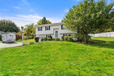
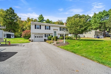

12 Patti Ln Maynard, MA 01754
Estimated payment $4,652/month
Highlights
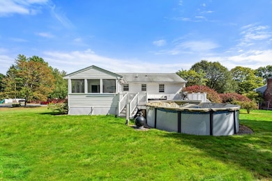
- Above Ground Pool
- Open Floorplan
- Living Room with Fireplace
- Sauna
- Deck
- Wooded Lot
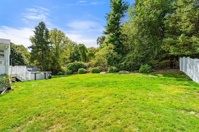
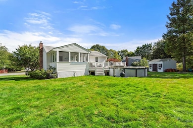
About This Home
Meticulously maintained split level in one of Maynard's most sought-after neighborhoods featuring 3 bedrooms, 2 modern full bathrooms, a large primary bedroom and a family room. Walk out the front door to a quiet neighborhood of wide streets for walking and biking or relax in the secluded back yard in your above ground pool. The large deck and Jacuzzi tub on the screened porch are like you own little oasis. An absolute must see! Maynard is centrally located to major routes and has a growing downtown with several restaurants.

Home Details
Home Type
- Single Family
Est. Annual Taxes
- $9,872
Year Built
- Built in 1978 | Remodeled
Lot Details
- 0.47 Acre Lot
- Property has an invisible fence for dogs
- Gentle Sloping Lot
- Sprinkler System
- Wooded Lot
- Property is zoned R2
Parking
- 1 Car Attached Garage
- Driveway
- Open Parking
- Off-Street Parking
Home Design
- Raised Ranch Architecture
- Split Level Home
- Frame Construction
- Blown Fiberglass Insulation
- Shingle Roof
- Concrete Perimeter Foundation
Interior Spaces
- Open Floorplan
- Wainscoting
- Recessed Lighting
- Picture Window
- Window Screens
- Living Room with Fireplace
- 2 Fireplaces
- Screened Porch
- Sauna
- Washer and Gas Dryer Hookup
Kitchen
- Range
- Dishwasher
- Disposal
Flooring
- Wood
- Wall to Wall Carpet
- Laminate
- Ceramic Tile
Bedrooms and Bathrooms
- 3 Bedrooms
- Primary Bedroom on Main
- 2 Full Bathrooms
- Double Vanity
- Soaking Tub
Partially Finished Basement
- Basement Fills Entire Space Under The House
- Garage Access
- Block Basement Construction
- Laundry in Basement
Home Security
- Storm Windows
- Storm Doors
Pool
- Above Ground Pool
- Spa
Outdoor Features
- Deck
- Outdoor Storage
Location
- Property is near schools
Schools
- Green Meadow Elementary School
- Fowler Middle School
- Maynard High School
Utilities
- Window Unit Cooling System
- 2 Heating Zones
- Heating System Uses Natural Gas
- Baseboard Heating
- 110 Volts
- Gas Water Heater
- Cable TV Available
Listing and Financial Details
- Assessor Parcel Number M:007.0 P:011.0,3634075
Community Details
Overview
- No Home Owners Association
- Near Conservation Area
Amenities
- Shops
- Coin Laundry
Recreation
- Bike Trail
Map
Home Values in the Area
Average Home Value in this Area
Tax History
| Year | Tax Paid | Tax Assessment Tax Assessment Total Assessment is a certain percentage of the fair market value that is determined by local assessors to be the total taxable value of land and additions on the property. | Land | Improvement |
|---|---|---|---|---|
| 2025 | $9,872 | $553,700 | $297,900 | $255,800 |
| 2024 | $9,337 | $522,200 | $283,800 | $238,400 |
| 2023 | $9,271 | $488,700 | $270,300 | $218,400 |
| 2022 | $8,895 | $433,500 | $227,100 | $206,400 |
| 2021 | $8,703 | $431,900 | $227,100 | $204,800 |
| 2020 | $8,636 | $418,400 | $205,500 | $212,900 |
| 2019 | $8,319 | $395,400 | $196,300 | $199,100 |
| 2018 | $6,122 | $344,300 | $178,500 | $165,800 |
| 2017 | $7,530 | $342,100 | $178,500 | $163,600 |
| 2016 | $7,285 | $342,800 | $178,500 | $164,300 |
| 2015 | $7,155 | $320,700 | $170,400 | $150,300 |
| 2014 | $6,685 | $299,900 | $165,000 | $134,900 |
Property History
| Date | Event | Price | List to Sale | Price per Sq Ft |
|---|---|---|---|---|
| 10/16/2025 10/16/25 | For Sale | $725,000 | -- | $458 / Sq Ft |
Purchase History
| Date | Type | Sale Price | Title Company |
|---|---|---|---|
| Deed | -- | -- | |
| Deed | -- | -- | |
| Deed | $179,000 | -- |
Mortgage History
| Date | Status | Loan Amount | Loan Type |
|---|---|---|---|
| Open | $20,000 | Purchase Money Mortgage | |
| Previous Owner | $40,000 | Purchase Money Mortgage | |
| Previous Owner | $250,000 | No Value Available | |
| Previous Owner | $246,000 | No Value Available | |
| Previous Owner | $60,000 | No Value Available |
Source: MLS Property Information Network (MLS PIN)
MLS Number: 73444659
APN: MAYN-000007-000000-000011
Disclaimer: Certain information contained herein is derived from information provided by parties other than Homes.com. All information provided is deemed reliable, but is not guaranteed to be accurate and should be independently verified.
![]() The property listing data and information, or the Images, set forth herein were provided to MLS Property Information Network, Inc. from third party sources, including sellers, lessors and public records, and were compiled by MLS Property Information Network, Inc. The property listing data and information, and the Images, are for the personal, non-commercial use of consumers having a good faith interest in purchasing or leasing listed properties of the type displayed to them and may not be used for any purpose other than to identify prospective properties which such consumers may have a good faith interest in purchasing or leasing. MLS Property Information Network, Inc. and its subscribers disclaim any and all representations and warranties as to the accuracy of the property listing data and information, or as to the accuracy of any of the Images, set forth herein.
The property listing data and information, or the Images, set forth herein were provided to MLS Property Information Network, Inc. from third party sources, including sellers, lessors and public records, and were compiled by MLS Property Information Network, Inc. The property listing data and information, and the Images, are for the personal, non-commercial use of consumers having a good faith interest in purchasing or leasing listed properties of the type displayed to them and may not be used for any purpose other than to identify prospective properties which such consumers may have a good faith interest in purchasing or leasing. MLS Property Information Network, Inc. and its subscribers disclaim any and all representations and warranties as to the accuracy of the property listing data and information, or as to the accuracy of any of the Images, set forth herein.
- 12 Nick Ln
- 6 Durant Ave
- 8 Glenn Dr
- 3 Apple Ridge Rd Unit 5
- 162 Summer St
- 220 Red Acre Rd
- 49 Summer Hill Rd
- 47 Summer Hill Rd
- 34 Meeting House Ln Unit 208
- 14 Faxon Dr Unit 14G
- 12 Assabet St
- 16 Pine St
- 1 Florida Ct Unit 3
- 25-27 Brooks St
- 16 Brooks St
- 260 Great Rd
- 4 Taylor Rd
- 20 Tremont St
- 91 Nason St
- 12 Walcott St
- 147 Red Acre Rd
- 10 Mill St Unit X
- 121 Summer Hill
- 10 Riverbank Rd Unit 2
- 165 Main St Unit 3
- 22 Johnston Way
- 14 Glendale St Unit 14
- 49 Douglas Ave Unit 51
- 19 Railroad St Unit A2
- 12 Digital Way
- 113 Central St
- 6 Powdermill Rd
- 117 Central St
- 8 Crestwood Ln
- 182 Main St
- 141-145 Waltham St
- 117 Central St Unit A-09
- 70 River St
- 206 Central St Unit 1
- 1 Nathan Pratt Dr