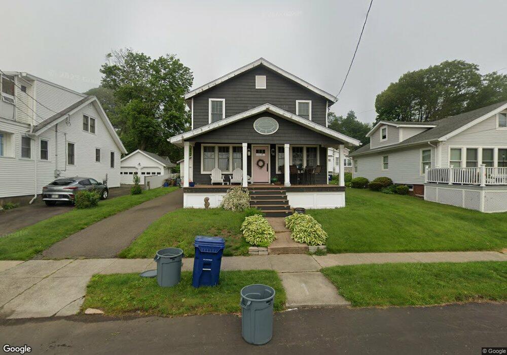
12 Platt Ave West Haven, CT 06516
West Shore NeighborhoodEstimated Value: $491,000 - $615,000
3
Beds
2
Baths
1,404
Sq Ft
$402/Sq Ft
Est. Value
About This Home
This home is located at 12 Platt Ave, West Haven, CT 06516 and is currently estimated at $564,668, approximately $402 per square foot. 12 Platt Ave is a home located in New Haven County with nearby schools including Carrigan 5/6 Intermediate School, Harry M. Bailey Middle School, and West Haven High School.
Ownership History
Date
Name
Owned For
Owner Type
Purchase Details
Closed on
Jan 15, 2009
Sold by
Vanmeredith Randall and Holt-Meredith Deborah
Bought by
Couden Patrick A and Couden Shannon L
Current Estimated Value
Home Financials for this Owner
Home Financials are based on the most recent Mortgage that was taken out on this home.
Original Mortgage
$213,600
Outstanding Balance
$137,445
Interest Rate
5.52%
Mortgage Type
Purchase Money Mortgage
Estimated Equity
$427,223
Create a Home Valuation Report for This Property
The Home Valuation Report is an in-depth analysis detailing your home's value as well as a comparison with similar homes in the area
Home Values in the Area
Average Home Value in this Area
Purchase History
| Date | Buyer | Sale Price | Title Company |
|---|---|---|---|
| Couden Patrick A | $267,000 | -- | |
| Couden Patrick A | $267,000 | -- |
Source: Public Records
Mortgage History
| Date | Status | Borrower | Loan Amount |
|---|---|---|---|
| Open | Couden Patrick A | $213,600 | |
| Closed | Couden Patrick A | $213,600 | |
| Previous Owner | Couden Patrick A | $147,250 |
Source: Public Records
Tax History Compared to Growth
Tax History
| Year | Tax Paid | Tax Assessment Tax Assessment Total Assessment is a certain percentage of the fair market value that is determined by local assessors to be the total taxable value of land and additions on the property. | Land | Improvement |
|---|---|---|---|---|
| 2025 | $12,110 | $368,410 | $178,780 | $189,630 |
| 2024 | $10,812 | $230,720 | $110,040 | $120,680 |
| 2023 | $10,405 | $230,720 | $110,040 | $120,680 |
| 2022 | $10,219 | $230,720 | $110,040 | $120,680 |
| 2021 | $10,219 | $230,720 | $110,040 | $120,680 |
| 2020 | $11,719 | $241,080 | $137,900 | $103,180 |
| 2019 | $11,345 | $241,080 | $137,900 | $103,180 |
| 2018 | $11,184 | $241,080 | $137,900 | $103,180 |
| 2017 | $10,882 | $241,080 | $137,900 | $103,180 |
| 2016 | $9,843 | $220,500 | $137,900 | $82,600 |
| 2015 | $9,776 | $245,140 | $153,790 | $91,350 |
| 2014 | $9,776 | $245,140 | $153,790 | $91,350 |
Source: Public Records
Map
Nearby Homes
- 45 Arlington St
- 74 Linden St
- 79 Linden St
- 99 Roosevelt Ave
- 137 Harding Ave
- 125 Harding Ave
- 191 Dawson Ave
- 76 Hawthorne St
- 40 Crest Ave
- 109 Parker Ave E
- 37 Wilson Ave
- 148 Central Ave
- 26 Lawncrest Rd
- 144 Hilltop Ln
- 314 Park St
- 798 W Main St
- 65 West Walk
- 31 West Walk Unit 31
- 77 Oxbow Ln
- 142 West Walk Unit 142