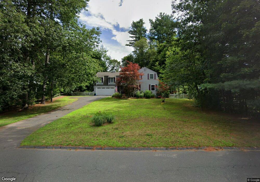
12 Riverside Rd Simsbury, CT 06070
Estimated Value: $483,000 - $666,000
4
Beds
3
Baths
2,397
Sq Ft
$228/Sq Ft
Est. Value
About This Home
This home is located at 12 Riverside Rd, Simsbury, CT 06070 and is currently estimated at $545,512, approximately $227 per square foot. 12 Riverside Rd is a home located in Hartford County with nearby schools including Tariffville School, Henry James Memorial School, and Simsbury High School.
Ownership History
Date
Name
Owned For
Owner Type
Purchase Details
Closed on
May 14, 2025
Sold by
Perreault Jill J
Bought by
Jill Perreault Ret and Perreault
Current Estimated Value
Purchase Details
Closed on
Nov 8, 2024
Sold by
Perreault Craig R
Bought by
Perreault Jill J
Create a Home Valuation Report for This Property
The Home Valuation Report is an in-depth analysis detailing your home's value as well as a comparison with similar homes in the area
Home Values in the Area
Average Home Value in this Area
Purchase History
| Date | Buyer | Sale Price | Title Company |
|---|---|---|---|
| Jill Perreault Ret | -- | None Available | |
| Jill Perreault Ret | -- | None Available | |
| Perreault Jill J | -- | None Available | |
| Perreault Jill J | -- | None Available |
Source: Public Records
Tax History
| Year | Tax Paid | Tax Assessment Tax Assessment Total Assessment is a certain percentage of the fair market value that is determined by local assessors to be the total taxable value of land and additions on the property. | Land | Improvement |
|---|---|---|---|---|
| 2025 | $8,716 | $255,150 | $80,850 | $174,300 |
| 2024 | $8,499 | $255,150 | $80,850 | $174,300 |
| 2023 | $8,457 | $265,790 | $80,850 | $184,940 |
| 2022 | $7,842 | $203,000 | $87,850 | $115,150 |
| 2021 | $7,842 | $203,000 | $87,850 | $115,150 |
| 2020 | $7,529 | $203,000 | $87,850 | $115,150 |
| 2019 | $7,576 | $203,000 | $87,850 | $115,150 |
| 2018 | $7,631 | $203,000 | $87,850 | $115,150 |
| 2017 | $7,109 | $183,420 | $85,610 | $97,810 |
| 2016 | $6,809 | $183,420 | $85,610 | $97,810 |
| 2015 | $6,809 | $183,420 | $85,610 | $97,810 |
| 2014 | $6,812 | $183,420 | $85,610 | $97,810 |
Source: Public Records
Map
Nearby Homes
- 10 Woods Ln
- 2 Gillette Ct Unit D
- 1 West St Unit 219
- 42 Library Ln Unit 42
- 3 Cobtail Way
- 15 Sand Hill Rd
- 9 Carriage Dr Unit 9
- 40 Firetown Rd Unit 22
- 30 Southbridge Ct Unit 30
- 6 Heritage Ln
- 24 Hunting Ridge Dr
- 63 Duncaster Rd
- 545 Simsbury Rd
- 28 Great Pond Rd
- 31 Oxford Ct
- 9 Barry Ln
- 90 Seminary Rd
- 60 Barry Ln
- 5 Shady Ln
- 126 Hopmeadow St Unit 3H
- 14 Riverside Rd
- 10 Riverside Rd
- 15 Riverside Rd
- 16 Riverside Rd
- 8 Riverside Rd
- 19 Riverside Rd
- 8 Bradley Rd
- 10 Bradley Rd
- 11 Riverside Rd
- 21 Riverside Rd
- 9 Riverside Rd
- 20 Riverside Rd
- 4 Bradley Rd
- 7 Riverside Rd
- 23 Riverside Rd
- 93 E Weatogue St
- 22 Riverside Rd
- 7 Bradley Rd
- 9 Bradley Rd
- 89 E Weatogue St
Your Personal Tour Guide
Ask me questions while you tour the home.