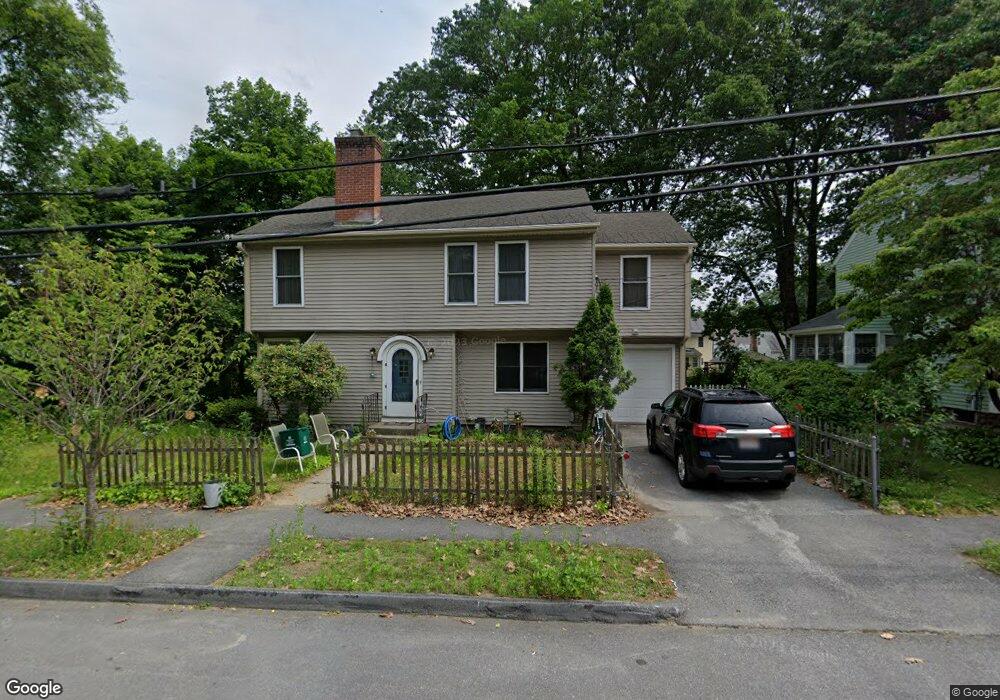
12 Sweetbriar Ln Worcester, MA 01602
Webster Square NeighborhoodEstimated Value: $425,000 - $469,909
3
Beds
1
Bath
1,287
Sq Ft
$348/Sq Ft
Est. Value
About This Home
This home is located at 12 Sweetbriar Ln, Worcester, MA 01602 and is currently estimated at $447,477, approximately $347 per square foot. 12 Sweetbriar Ln is a home located in Worcester County with nearby schools including Chandler Magnet, Jacob Hiatt Magnet School, and May Street Elementary School.
Ownership History
Date
Name
Owned For
Owner Type
Purchase Details
Closed on
Mar 5, 2020
Sold by
Brown Kristen L
Bought by
Brown Chance A
Current Estimated Value
Purchase Details
Closed on
May 31, 1996
Sold by
Kozak Scott M and Kozak Linda
Bought by
Brown Chance A and Brown Kristen
Home Financials for this Owner
Home Financials are based on the most recent Mortgage that was taken out on this home.
Original Mortgage
$79,800
Interest Rate
7.91%
Mortgage Type
Purchase Money Mortgage
Purchase Details
Closed on
Jul 2, 1993
Sold by
Potvin Thomas S
Bought by
Kozaka Scott and Fries Linda
Home Financials for this Owner
Home Financials are based on the most recent Mortgage that was taken out on this home.
Original Mortgage
$83,125
Interest Rate
7.46%
Mortgage Type
Purchase Money Mortgage
Purchase Details
Closed on
Jan 27, 1992
Sold by
Joseph Robert E
Bought by
Potvin Thomas S
Purchase Details
Closed on
Dec 26, 1989
Sold by
Marois Mary
Bought by
Joseph Robert E
Create a Home Valuation Report for This Property
The Home Valuation Report is an in-depth analysis detailing your home's value as well as a comparison with similar homes in the area
Home Values in the Area
Average Home Value in this Area
Purchase History
| Date | Buyer | Sale Price | Title Company |
|---|---|---|---|
| Brown Chance A | -- | None Available | |
| Brown Chance A | $84,000 | -- | |
| Kozaka Scott | $87,500 | -- | |
| Potvin Thomas S | $70,100 | -- | |
| Joseph Robert E | $101,000 | -- |
Source: Public Records
Mortgage History
| Date | Status | Borrower | Loan Amount |
|---|---|---|---|
| Previous Owner | Joseph Robert E | $177,300 | |
| Previous Owner | Joseph Robert E | $79,800 | |
| Previous Owner | Joseph Robert E | $83,125 |
Source: Public Records
Tax History Compared to Growth
Tax History
| Year | Tax Paid | Tax Assessment Tax Assessment Total Assessment is a certain percentage of the fair market value that is determined by local assessors to be the total taxable value of land and additions on the property. | Land | Improvement |
|---|---|---|---|---|
| 2025 | $5,350 | $405,600 | $97,600 | $308,000 |
| 2024 | $5,217 | $379,400 | $97,600 | $281,800 |
| 2023 | $5,025 | $350,400 | $84,900 | $265,500 |
| 2022 | $4,648 | $305,600 | $67,900 | $237,700 |
| 2021 | $4,606 | $282,900 | $54,300 | $228,600 |
| 2020 | $4,432 | $260,700 | $53,900 | $206,800 |
| 2019 | $4,241 | $235,600 | $47,100 | $188,500 |
| 2018 | $4,196 | $221,900 | $47,100 | $174,800 |
| 2017 | $4,015 | $208,900 | $47,100 | $161,800 |
| 2016 | $4,013 | $194,700 | $33,300 | $161,400 |
| 2015 | $3,908 | $194,700 | $33,300 | $161,400 |
| 2014 | $3,804 | $194,700 | $33,300 | $161,400 |
Source: Public Records
Map
Nearby Homes
- 5 Swan Ave
- 41 Walnut Hill Dr
- 45 Fourth St
- 45 Fourth St Unit Right
- 47 4th St
- 5 Amber St
- 415 Mill St
- 71 Glendale St
- 57 1st St
- 250 May St
- 15 Circuit Ave E
- 47R Yarnie Unit 3B
- 47R Yarnie Unit 3A
- 47R Yarnie Unit 1B
- 47R Yarnie Unit 2B
- 47R Yarnie Unit 4B
- 47R Yarnie Unit 8B
- 47R Yarnie Unit 5A
- 47R Yarnie Unit 6B
- 47R Yarnie Unit 4A