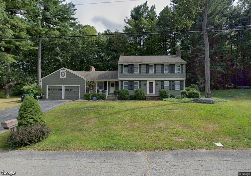
12 Todd Rd Nashua, NH 03064
Northeast Nashua NeighborhoodEstimated Value: $659,741 - $714,000
4
Beds
3
Baths
2,196
Sq Ft
$311/Sq Ft
Est. Value
About This Home
This home is located at 12 Todd Rd, Nashua, NH 03064 and is currently estimated at $683,185, approximately $311 per square foot. 12 Todd Rd is a home located in Hillsborough County with nearby schools including Charlotte Ave Elementary School, Pennichuck Middle School, and Nashua High School North.
Ownership History
Date
Name
Owned For
Owner Type
Purchase Details
Closed on
Dec 13, 2017
Sold by
Cardin Elaine R
Bought by
Sullivan Brian A and Sullivan Sara C
Current Estimated Value
Home Financials for this Owner
Home Financials are based on the most recent Mortgage that was taken out on this home.
Original Mortgage
$351,000
Outstanding Balance
$298,549
Interest Rate
3.94%
Mortgage Type
New Conventional
Estimated Equity
$384,636
Purchase Details
Closed on
Mar 11, 1994
Bought by
Elaine R Cardin Ret
Create a Home Valuation Report for This Property
The Home Valuation Report is an in-depth analysis detailing your home's value as well as a comparison with similar homes in the area
Home Values in the Area
Average Home Value in this Area
Purchase History
| Date | Buyer | Sale Price | Title Company |
|---|---|---|---|
| Sullivan Brian A | $390,000 | -- | |
| Elaine R Cardin Ret | -- | -- |
Source: Public Records
Mortgage History
| Date | Status | Borrower | Loan Amount |
|---|---|---|---|
| Open | Sullivan Brian A | $351,000 |
Source: Public Records
Tax History Compared to Growth
Tax History
| Year | Tax Paid | Tax Assessment Tax Assessment Total Assessment is a certain percentage of the fair market value that is determined by local assessors to be the total taxable value of land and additions on the property. | Land | Improvement |
|---|---|---|---|---|
| 2024 | $9,330 | $586,800 | $177,800 | $409,000 |
| 2023 | $8,836 | $484,700 | $142,300 | $342,400 |
| 2022 | $8,759 | $484,700 | $142,300 | $342,400 |
| 2021 | $7,818 | $336,700 | $99,600 | $237,100 |
| 2020 | $7,629 | $337,400 | $99,600 | $237,800 |
| 2019 | $7,342 | $337,400 | $99,600 | $237,800 |
| 2018 | $7,156 | $337,400 | $99,600 | $237,800 |
| 2017 | $7,500 | $290,800 | $85,500 | $205,300 |
| 2016 | $7,290 | $290,800 | $85,500 | $205,300 |
| 2015 | $7,133 | $290,800 | $85,500 | $205,300 |
| 2014 | $6,994 | $290,800 | $85,500 | $205,300 |
Source: Public Records
Map
Nearby Homes
- 33 Ferry Rd
- 30 Burgess St
- 17 Danbury Rd
- 74 Profile Cir
- 123 Cannongate III
- 9 Elystan Cir
- 74 Cannongate III Unit 3
- 3 Wright Rd
- 31 Ashland St
- 12 Juliana Ave Unit 14
- 3 Opal Way Unit 3
- 1 Opal Way Unit 1
- 2 Opal Way Unit 2
- 31 Juliana Ave
- 31 Juliana Ave Unit 4
- 11 Juliana Ave Unit 52
- 19 Bartlett Ave
- 40 Merrimack Dr
- 113 Concord St
- 11 Amherst Terrace
- 14 Todd Rd
- 11 Todd Rd
- 10 Todd Rd
- 9 Todd Rd
- 13 Todd Rd
- 16 Todd Rd
- 7 Todd Rd
- 8 Todd Rd
- 15 Todd Rd
- 51 Dorchester Way Unit U120
- 53 Dorchester Way Unit U119
- 55 Dorchester Way Unit U118
- 57 Dorchester Way Unit U117
- 49 Dorchester Way Unit U121
- 59 Dorchester Way Unit U116
- 61 Dorchester Way Unit U115
- 63 Dorchester Way Unit U114
- 6 Todd Rd
- 18 Todd Rd
- 105 Fawn Ln