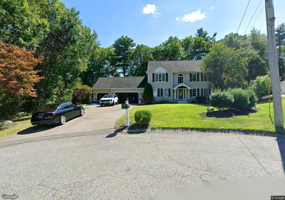
12 Upland Dr North Attleboro, MA 02760
North Attleboro NeighborhoodEstimated Value: $692,000 - $727,000
3
Beds
3
Baths
1,960
Sq Ft
$365/Sq Ft
Est. Value
About This Home
This home is located at 12 Upland Dr, North Attleboro, MA 02760 and is currently estimated at $715,579, approximately $365 per square foot. 12 Upland Dr is a home located in Bristol County with nearby schools including North Attleboro High School, Cadence Academy Preschool - North Attleborough, and St John The Evangelist School.
Ownership History
Date
Name
Owned For
Owner Type
Purchase Details
Closed on
May 30, 1997
Sold by
Hurder Homes Inc
Bought by
Thoener Marc J and Thoener Deborah J
Current Estimated Value
Purchase Details
Closed on
May 17, 1996
Sold by
Hurder Homes Inc
Bought by
Dercole Frank J and Rabitor Mary A
Create a Home Valuation Report for This Property
The Home Valuation Report is an in-depth analysis detailing your home's value as well as a comparison with similar homes in the area
Home Values in the Area
Average Home Value in this Area
Purchase History
| Date | Buyer | Sale Price | Title Company |
|---|---|---|---|
| Thoener Marc J | $209,000 | -- | |
| Dercole Frank J | $205,000 | -- |
Source: Public Records
Mortgage History
| Date | Status | Borrower | Loan Amount |
|---|---|---|---|
| Open | Dercole Frank J | $161,400 | |
| Closed | Dercole Frank J | $173,000 | |
| Closed | Dercole Frank J | $210,000 |
Source: Public Records
Tax History Compared to Growth
Tax History
| Year | Tax Paid | Tax Assessment Tax Assessment Total Assessment is a certain percentage of the fair market value that is determined by local assessors to be the total taxable value of land and additions on the property. | Land | Improvement |
|---|---|---|---|---|
| 2025 | $7,319 | $620,800 | $156,100 | $464,700 |
| 2024 | $7,360 | $637,800 | $156,100 | $481,700 |
| 2023 | $7,111 | $556,000 | $162,900 | $393,100 |
| 2022 | $6,640 | $476,700 | $156,100 | $320,600 |
| 2021 | $6,523 | $457,100 | $156,100 | $301,000 |
| 2020 | $6,436 | $448,500 | $156,100 | $292,400 |
| 2019 | $6,234 | $437,800 | $142,000 | $295,800 |
| 2018 | $5,609 | $420,500 | $142,000 | $278,500 |
| 2017 | $5,559 | $420,500 | $142,000 | $278,500 |
| 2016 | $5,511 | $416,900 | $164,700 | $252,200 |
| 2015 | $4,998 | $380,400 | $171,500 | $208,900 |
| 2014 | $4,757 | $359,300 | $150,400 | $208,900 |
Source: Public Records
Map
Nearby Homes
- 115 Westfield Dr
- 11 Buckthorn Ln
- 57 Vine St
- 546 Towne St
- 36 Cranberry Rd
- 59 Laurelwood Dr
- 11 Landry Ave
- Lot 2 Jeffrey Dr
- 20 Sperry Ln
- 10 Sleepy Hollow Cir
- Lot 5 Jeffrey Dr
- 70 Sperry Ln Unit Lot 11
- 21 Shady Ln
- 6 Colts Way
- 122 Mary Ann Way
- 12 Houde St
- 158 Ivy St
- 16 Raymond Hall Dr
- 18 Quincy Way
- 15 Old Wood Rd
- 2 Upland Dr
- 22 Upland Dr
- 11 Pine Ledge Terrace
- 12 Pine Ledge Terrace
- 31 Upland Dr
- 21 Upland Dr
- 1 Pine Ledge Terrace
- 200 Kelley Blvd
- 11 Upland Dr
- 190 Kelley Blvd
- 2 Pine Ledge Terrace
- 212 Kelley Blvd
- 206 Kelley Blvd
- 46 Westfield Dr
- 1 Upland Dr
- 54 Westfield Dr
- 182 Kelley Blvd
- 36 Westfield Dr
- 2 Wintergreen Dr
- 3 Upland Dr