
Seller's Agent in 2025
Edith Hill
Keller Williams Realty Boston Northwest
(978) 369-5775
2 in this area
26 Total Sales
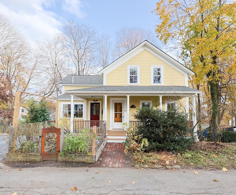
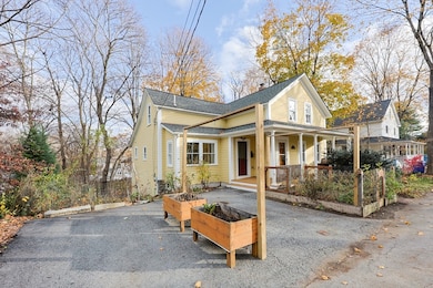
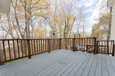
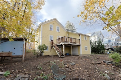
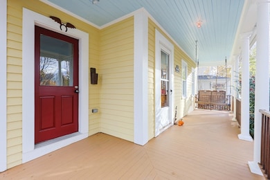
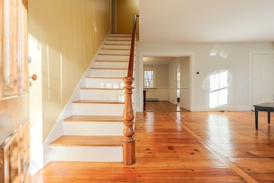
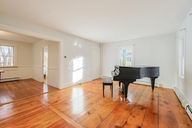
Welcoming Village Colonial with a true sanctuary feel, loved by artists and conservationists. Surrounded by mature gardens, a fenced chicken coop, and town-owned land both behind the home and across the street, nature is ever-present. Enjoy peaceful treetop views from the private deck. Inside, the light-filled living room opens to the dining room and a flexible study or 4th bedroom. The charming kitchen offers a breakfast nook, spacious walk-in pantry, laundry closet, and full bath. Upstairs are three bedrooms, a full bath, and storage. The walkout basement includes a playroom and potting shed. With newer windows and beautifully kept floors, this tranquil retreat is ready to welcome its next owners.
Last Agent to Sell the Property
Keller Williams Realty Boston Northwest Listed on: 11/18/2025
| Date | Type | Sale Price | Title Company |
|---|---|---|---|
| Quit Claim Deed | $610,000 | -- | |
| Deed | $359,250 | -- | |
| Deed | $359,250 | -- | |
| Deed | $172,000 | -- | |
| Deed | $107,000 | -- | |
| Deed | $107,000 | -- |
| Date | Status | Loan Amount | Loan Type |
|---|---|---|---|
| Open | $579,500 | New Conventional | |
| Previous Owner | $341,200 | Purchase Money Mortgage | |
| Previous Owner | $165,150 | No Value Available | |
| Previous Owner | $167,050 | Purchase Money Mortgage |
| Date | Event | Price | List to Sale | Price per Sq Ft |
|---|---|---|---|---|
| 12/29/2025 12/29/25 | Sold | $610,000 | +3.6% | $434 / Sq Ft |
| 11/25/2025 11/25/25 | Pending | -- | -- | -- |
| 11/18/2025 11/18/25 | For Sale | $589,000 | -- | $419 / Sq Ft |
| Year | Tax Paid | Tax Assessment Tax Assessment Total Assessment is a certain percentage of the fair market value that is determined by local assessors to be the total taxable value of land and additions on the property. | Land | Improvement |
|---|---|---|---|---|
| 2025 | $8,328 | $467,100 | $247,500 | $219,600 |
| 2024 | $7,270 | $406,600 | $235,700 | $170,900 |
| 2023 | $7,182 | $378,600 | $221,300 | $157,300 |
| 2022 | $7,176 | $349,700 | $192,400 | $157,300 |
| 2021 | $7,038 | $349,300 | $187,600 | $161,700 |
| 2020 | $7,110 | $344,500 | $182,800 | $161,700 |
| 2019 | $6,522 | $310,000 | $161,100 | $148,900 |
| 2018 | $5,839 | $257,900 | $141,400 | $116,500 |
| 2017 | $5,676 | $257,900 | $141,400 | $116,500 |
| 2016 | $5,480 | $257,900 | $141,400 | $116,500 |
| 2015 | $5,301 | $237,600 | $138,500 | $99,100 |
| 2014 | $5,158 | $231,400 | $132,300 | $99,100 |
Seller's Agent in 2025
Edith Hill
Keller Williams Realty Boston Northwest
(978) 369-5775
2 in this area
26 Total Sales
T
Seller Co-Listing Agent in 2025
Tim Hill
Keller Williams Realty Boston Northwest
1 in this area
6 Total Sales
R
Buyer's Agent in 2025
Real Estate Advisors Group
Coldwell Banker Realty - Belmont
1 in this area
24 Total Sales
Source: MLS Property Information Network (MLS PIN)
MLS Number: 73455918
APN: MAYN-000010-000000-000219
Disclaimer: Certain information contained herein is derived from information provided by parties other than Homes.com. All information provided is deemed reliable, but is not guaranteed to be accurate and should be independently verified.
![]() The property listing data and information, or the Images, set forth herein were provided to MLS Property Information Network, Inc. from third party sources, including sellers, lessors and public records, and were compiled by MLS Property Information Network, Inc. The property listing data and information, and the Images, are for the personal, non-commercial use of consumers having a good faith interest in purchasing or leasing listed properties of the type displayed to them and may not be used for any purpose other than to identify prospective properties which such consumers may have a good faith interest in purchasing or leasing. MLS Property Information Network, Inc. and its subscribers disclaim any and all representations and warranties as to the accuracy of the property listing data and information, or as to the accuracy of any of the Images, set forth herein.
The property listing data and information, or the Images, set forth herein were provided to MLS Property Information Network, Inc. from third party sources, including sellers, lessors and public records, and were compiled by MLS Property Information Network, Inc. The property listing data and information, and the Images, are for the personal, non-commercial use of consumers having a good faith interest in purchasing or leasing listed properties of the type displayed to them and may not be used for any purpose other than to identify prospective properties which such consumers may have a good faith interest in purchasing or leasing. MLS Property Information Network, Inc. and its subscribers disclaim any and all representations and warranties as to the accuracy of the property listing data and information, or as to the accuracy of any of the Images, set forth herein.
Ask me questions while you tour the home.