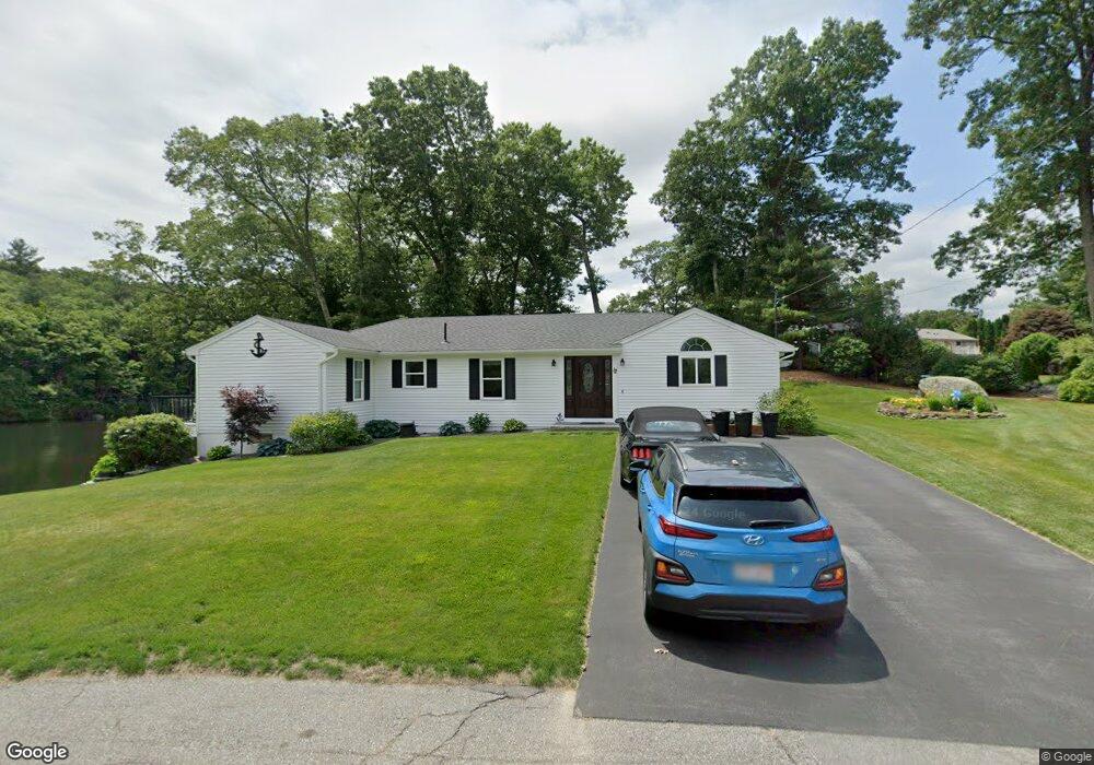
12 Warren St Millbury, MA 01527
Estimated Value: $482,000 - $796,167
3
Beds
4
Baths
1,788
Sq Ft
$382/Sq Ft
Est. Value
About This Home
This home is located at 12 Warren St, Millbury, MA 01527 and is currently estimated at $683,542, approximately $382 per square foot. 12 Warren St is a home located in Worcester County with nearby schools including Elmwood Street Elementary School, Raymond E. Shaw Elementary School, and Millbury Junior/Senior High School.
Ownership History
Date
Name
Owned For
Owner Type
Purchase Details
Closed on
Nov 21, 2016
Sold by
Bertrand Ft and Bertrand
Bought by
Conley Michael B and Conley Nancy S
Current Estimated Value
Home Financials for this Owner
Home Financials are based on the most recent Mortgage that was taken out on this home.
Original Mortgage
$288,900
Outstanding Balance
$231,937
Interest Rate
3.42%
Mortgage Type
New Conventional
Estimated Equity
$451,605
Purchase Details
Closed on
Sep 21, 2006
Sold by
Bertrand Rt and Bertrand
Bought by
Bertrand Ft and Bertrand
Create a Home Valuation Report for This Property
The Home Valuation Report is an in-depth analysis detailing your home's value as well as a comparison with similar homes in the area
Home Values in the Area
Average Home Value in this Area
Purchase History
| Date | Buyer | Sale Price | Title Company |
|---|---|---|---|
| Conley Michael B | $332,000 | -- | |
| Conley Michael B | $332,000 | -- | |
| Bertrand Ft | -- | -- | |
| Bertrand Ft | -- | -- |
Source: Public Records
Mortgage History
| Date | Status | Borrower | Loan Amount |
|---|---|---|---|
| Open | Conley Michael B | $288,900 | |
| Closed | Conley Michael B | $288,900 |
Source: Public Records
Tax History Compared to Growth
Tax History
| Year | Tax Paid | Tax Assessment Tax Assessment Total Assessment is a certain percentage of the fair market value that is determined by local assessors to be the total taxable value of land and additions on the property. | Land | Improvement |
|---|---|---|---|---|
| 2025 | $10,578 | $789,974 | $380,074 | $409,900 |
| 2024 | $9,700 | $733,181 | $351,681 | $381,500 |
| 2023 | $7,389 | $511,366 | $182,166 | $329,200 |
| 2022 | $7,166 | $477,766 | $182,166 | $295,600 |
| 2021 | $14,491 | $458,866 | $182,166 | $276,700 |
| 2020 | $6,460 | $421,400 | $151,800 | $269,600 |
| 2019 | $5,326 | $336,000 | $137,700 | $198,300 |
| 2018 | $4,694 | $287,300 | $137,700 | $149,600 |
| 2017 | $4,568 | $278,000 | $137,700 | $140,300 |
| 2016 | $4,327 | $262,900 | $137,700 | $125,200 |
| 2015 | $4,426 | $268,900 | $146,700 | $122,200 |
| 2014 | $3,870 | $226,300 | $106,400 | $119,900 |
Source: Public Records
Map
Nearby Homes
- 90 Macarthur Dr
- 64 Millbury Ave
- 123 Riverlin St
- 12 Alstead Path
- 3 May St
- 52 Clearview Terrace Unit 39
- 2 Diane St
- 86 Wheelock Ave
- 15 Rayburn Dr
- 1 Broadmeadow Ave
- 1 Pineland Ave
- 11 Westview Ave
- 15 Clearview Terrace Unit 68
- 17 Atwood Ave
- 12 Irene Ct
- 90 Park Hill Ave
- 330 Millbury Ave
- 20 Woodridge Rd
- 40 River St
- 16 Jackie Dr