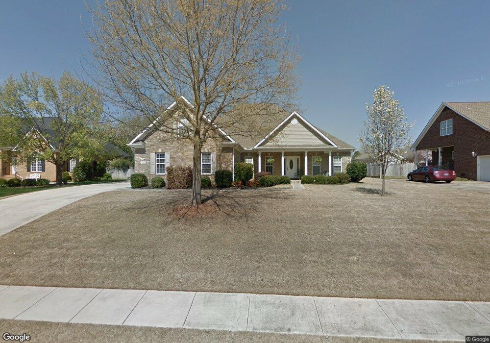
120 Bridgefield Rd Madison, AL 35758
Estimated Value: $312,000 - $389,000
Studio
--
Bath
1,464
Sq Ft
$241/Sq Ft
Est. Value
About This Home
This home is located at 120 Bridgefield Rd, Madison, AL 35758 and is currently estimated at $353,550, approximately $241 per square foot. 120 Bridgefield Rd is a home with nearby schools including Discovery Middle School, Bob Jones High School, and St John the Baptist Catholic School.
Ownership History
Date
Name
Owned For
Owner Type
Purchase Details
Closed on
Aug 26, 2019
Sold by
New Castle Development Inc
Bought by
Valor Communities Llc
Current Estimated Value
Home Financials for this Owner
Home Financials are based on the most recent Mortgage that was taken out on this home.
Original Mortgage
$292,000
Interest Rate
3.8%
Mortgage Type
Construction
Purchase Details
Closed on
Sep 28, 2016
Sold by
Swanson Carol Spencer
Bought by
Swanson Carol S
Create a Home Valuation Report for This Property
The Home Valuation Report is an in-depth analysis detailing your home's value as well as a comparison with similar homes in the area
Home Values in the Area
Average Home Value in this Area
Purchase History
| Date | Buyer | Sale Price | Title Company |
|---|---|---|---|
| Valor Communities Llc | $43,750 | None Available | |
| Swanson Carol S | $27,500 | None Available |
Source: Public Records
Mortgage History
| Date | Status | Borrower | Loan Amount |
|---|---|---|---|
| Closed | Valor Communities Llc | $292,000 |
Source: Public Records
Tax History
| Year | Tax Paid | Tax Assessment Tax Assessment Total Assessment is a certain percentage of the fair market value that is determined by local assessors to be the total taxable value of land and additions on the property. | Land | Improvement |
|---|---|---|---|---|
| 2025 | $2,331 | $34,080 | $7,500 | $26,580 |
| 2024 | $2,331 | $33,440 | $7,500 | $25,940 |
| 2023 | $2,204 | $32,400 | $7,500 | $24,900 |
| 2022 | $1,709 | $25,140 | $3,500 | $21,640 |
| 2021 | $1,548 | $22,820 | $3,500 | $19,320 |
| 2020 | $1,438 | $21,240 | $3,000 | $18,240 |
| 2019 | $1,140 | $20,470 | $3,000 | $17,470 |
| 2018 | $1,074 | $19,340 | $0 | $0 |
| 2017 | $1,065 | $19,180 | $0 | $0 |
| 2016 | $1,065 | $19,180 | $0 | $0 |
| 2015 | $1,065 | $19,180 | $0 | $0 |
| 2014 | $1,093 | $19,840 | $0 | $0 |
Source: Public Records
Map
Nearby Homes
- 106 Teal Park Ln
- 103 Wigon Cir
- 141 Bellingham Dr
- 107 Garden Brook Dr
- 210 Garden Brook Dr
- 210 Overbrook Dr
- 164 Silo Hill Rd
- 108 Philadelphia Dr
- 117 Spotted Fawn Rd
- 104 Cavendish Cir
- 1262 Cathedral Cir
- 1263 Cathedral Cir
- 103 Lanthorn Cir
- 203 Coach Lamp Dr
- 137 Spotted Fawn Rd
- 101 Mickelo Ln
- 1133 Cathedral Cir
- 111 Fieldmaster Dr
- 105 Markum Ln
- 108 Pitalo St
- 122 Bridgefield Rd
- 118 Bridgefield Rd
- 107 Durham Dr
- 105 Durham Dr
- 124 Bridgefield Rd
- 116 Bridgefield Rd
- 121 Bridgefield Rd
- 109 Durham Dr
- 103 Durham Dr
- 123 Bridgefield Rd
- 117 Bridgefield Rd
- 126 Bridgefield Rd
- 111 Durham Dr
- 114 Bridgefield Rd
- 125 Bridgefield Rd
- 115 Bridgefield Rd
- 101 Durham Dr
- 106 Durham Dr
- 108 Durham Dr
- 113 Durham Dr
Your Personal Tour Guide
Ask me questions while you tour the home.