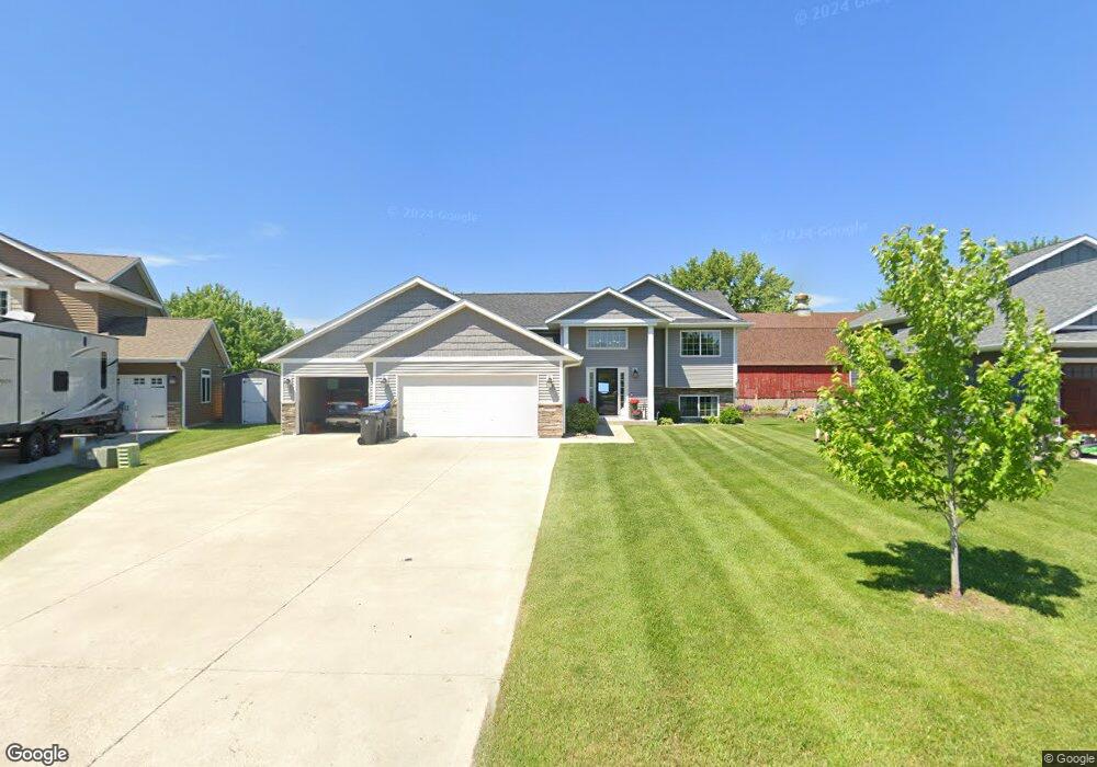
120 Foxfire Dr Mankato, MN 56001
Eastwood Park NeighborhoodEstimated Value: $399,000 - $433,000
4
Beds
3
Baths
1,199
Sq Ft
$343/Sq Ft
Est. Value
About This Home
This home is located at 120 Foxfire Dr, Mankato, MN 56001 and is currently estimated at $411,237, approximately $342 per square foot. 120 Foxfire Dr is a home with nearby schools including Washington Elementary School, Prairie Winds Middle School, and Mankato East Senior High School.
Ownership History
Date
Name
Owned For
Owner Type
Purchase Details
Closed on
Dec 11, 2015
Sold by
Heartland Homes Of Mankato Llc
Bought by
Barnes Troy and Barnes Heather
Current Estimated Value
Home Financials for this Owner
Home Financials are based on the most recent Mortgage that was taken out on this home.
Original Mortgage
$194,300
Outstanding Balance
$156,323
Interest Rate
3.96%
Mortgage Type
New Conventional
Estimated Equity
$254,914
Create a Home Valuation Report for This Property
The Home Valuation Report is an in-depth analysis detailing your home's value as well as a comparison with similar homes in the area
Home Values in the Area
Average Home Value in this Area
Purchase History
| Date | Buyer | Sale Price | Title Company |
|---|---|---|---|
| Barnes Troy | $242,900 | -- | |
| Heartland Homes Of Mankato Llc | -- | -- |
Source: Public Records
Mortgage History
| Date | Status | Borrower | Loan Amount |
|---|---|---|---|
| Open | Heartland Homes Of Mankato Llc | $194,300 | |
| Closed | Barnes Troy | $194,300 |
Source: Public Records
Tax History Compared to Growth
Tax History
| Year | Tax Paid | Tax Assessment Tax Assessment Total Assessment is a certain percentage of the fair market value that is determined by local assessors to be the total taxable value of land and additions on the property. | Land | Improvement |
|---|---|---|---|---|
| 2025 | $4,088 | $380,400 | $38,600 | $341,800 |
| 2024 | $4,088 | $371,400 | $38,600 | $332,800 |
| 2023 | $4,092 | $362,600 | $38,600 | $324,000 |
| 2022 | $3,396 | $353,500 | $38,600 | $314,900 |
| 2021 | $3,298 | $277,600 | $38,600 | $239,000 |
| 2020 | $3,158 | $258,400 | $38,600 | $219,800 |
| 2019 | $2,994 | $258,400 | $38,600 | $219,800 |
| 2018 | $2,854 | $245,800 | $32,200 | $213,600 |
| 2017 | $2,284 | $223,300 | $32,200 | $191,100 |
| 2016 | $350 | $186,800 | $32,200 | $154,600 |
| 2015 | $3 | $29,000 | $29,000 | $0 |
| 2014 | $196 | $87,000 | $87,000 | $0 |
Source: Public Records
Map
Nearby Homes
- 120 Butler Falls Ct
- 116 Butler Falls Ct
- 124 Butler Falls Rd
- 128 Butler Falls Rd
- 132 Butler Falls Rd
- 136 Butler Falls Rd
- 106 Butler Falls Ct
- 301 Pinehurst Dr
- 102 Butler Falls Ct
- 305 Pinehurst Dr
- 108 Butler Falls Rd
- 309 Pinehurst Dr
- 225 Pinehurst Dr
- 104 Butler Falls Rd
- 121 Pine Creek Rd
- 300 Pinehurst Dr
- 304 Pinehurst Dr
- 117 Pine Creek Rd
- 403 Pinehurst Dr
- 113 Pine Creek Rd
- 116 Foxfire Dr
- 124 Foxfire Dr
- 128 Foxfire Dr
- 112 Foxfire Dr
- 117 Foxfire Dr
- 132 Foxfire Dr
- 108 108 Foxfire Dr
- 108 Foxfire Dr
- 113 113 Foxfire Dr
- 113 Foxfire Dr
- 136 Foxfire Dr
- 58501 227th St
- 109 109 Foxfire Dr
- 104 Foxfire Dr
- 125 Foxfire Dr
- 140 Foxfire Dr
- 109 Foxfire Dr
- 132 Harbor Hill Dr
- 144 Foxfire Dr
- 105 Foxfire Dr