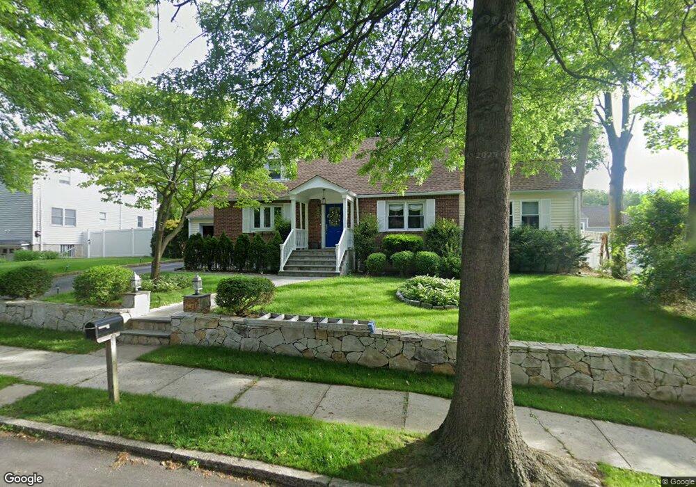
120 Locust Ave E West Harrison, NY 10604
West Harrison NeighborhoodEstimated Value: $810,976 - $1,002,000
--
Bed
2
Baths
1,913
Sq Ft
$472/Sq Ft
Est. Value
About This Home
This home is located at 120 Locust Ave E, West Harrison, NY 10604 and is currently estimated at $901,994, approximately $471 per square foot. 120 Locust Ave E is a home located in Westchester County with nearby schools including Samuel J. Preston Elementary School, Louis M. Klein Middle School, and Harrison High School.
Ownership History
Date
Name
Owned For
Owner Type
Purchase Details
Closed on
Mar 29, 2001
Sold by
Salvo Edward J and Mezzancello Joan E
Bought by
Erb Randall P and Massaro Erb Susan A
Current Estimated Value
Home Financials for this Owner
Home Financials are based on the most recent Mortgage that was taken out on this home.
Original Mortgage
$256,000
Outstanding Balance
$93,528
Interest Rate
6.9%
Mortgage Type
Purchase Money Mortgage
Estimated Equity
$808,466
Create a Home Valuation Report for This Property
The Home Valuation Report is an in-depth analysis detailing your home's value as well as a comparison with similar homes in the area
Home Values in the Area
Average Home Value in this Area
Purchase History
| Date | Buyer | Sale Price | Title Company |
|---|---|---|---|
| Erb Randall P | $320,000 | -- |
Source: Public Records
Mortgage History
| Date | Status | Borrower | Loan Amount |
|---|---|---|---|
| Open | Erb Randall P | $256,000 |
Source: Public Records
Tax History Compared to Growth
Tax History
| Year | Tax Paid | Tax Assessment Tax Assessment Total Assessment is a certain percentage of the fair market value that is determined by local assessors to be the total taxable value of land and additions on the property. | Land | Improvement |
|---|---|---|---|---|
| 2024 | $13,250 | $8,000 | $1,180 | $6,820 |
| 2023 | $14,115 | $8,000 | $1,180 | $6,820 |
| 2022 | $12,514 | $8,000 | $1,180 | $6,820 |
| 2021 | $12,273 | $8,000 | $1,180 | $6,820 |
| 2020 | $12,128 | $8,000 | $1,180 | $6,820 |
| 2019 | $12,633 | $8,000 | $1,180 | $6,820 |
| 2018 | $6,821 | $8,000 | $1,180 | $6,820 |
| 2017 | $0 | $8,000 | $1,180 | $6,820 |
| 2016 | $12,041 | $8,000 | $1,180 | $6,820 |
| 2015 | -- | $8,000 | $1,180 | $6,820 |
| 2014 | -- | $8,000 | $1,180 | $6,820 |
| 2013 | -- | $8,000 | $1,180 | $6,820 |
Source: Public Records
Map
Nearby Homes
- 43 Columbus Ave Unit 1B
- 423 Westchester Ave
- 38 Underhill Ave Unit 2A
- 31 Colonial Rd
- 62 Underhill Ave Unit 1A
- 97 Columbus Ave Unit 2B
- 18 Gainsborg Ave E
- 107 Columbus Ave Unit 2A
- 121 Columbus Ave Unit 1A
- 189 Columbus Ave Unit 1B
- 196 Underhill Ave Unit 2A
- 60 Park Ave
- 6 Century Ridge Rd
- 17 Edward St
- 251 Columbus Ave
- 196 Gainsborg Ave E
- 194 Gainsborg Ave E
- 30 Windsor Terrace Unit 4J
- 25 Franklin Ave Unit 2K
- 25 Franklin Ave Unit 6K
- 1 Main Place
- 130 Locust Ave E
- 119 Parkview Ave E
- 121 Parkview Ave E
- 3 Main Place
- 127 Parkview Ave E
- 150 Locust Ave E
- 104 Locust Ave E
- 103 Locust Ave E
- 102 Parkview Ave E
- 118 Parkview Ave E
- 2 Main Place
- 100 Parkview Ave E Unit 1
- 100 Parkview Ave E
- 96 Locust Ave E
- 96 Parkview Ave E
- 97 Locust Ave E
- 89 Parkview Ave E
- 43 High St
- 39 High St