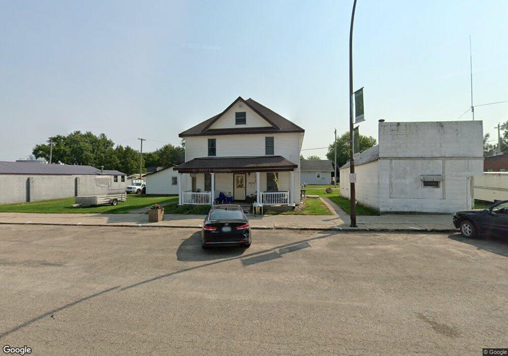
120 N Franklin St Dow City, IA 51528
Estimated Value: $127,000
--
Bed
4
Baths
3,210
Sq Ft
$40/Sq Ft
Est. Value
About This Home
This home is located at 120 N Franklin St, Dow City, IA 51528 and is currently estimated at $127,000, approximately $39 per square foot. 120 N Franklin St is a home with nearby schools including Boyer Valley Elementary School and Boyer Valley Middle/High School.
Ownership History
Date
Name
Owned For
Owner Type
Purchase Details
Closed on
Jul 14, 2023
Sold by
Garrett Trucking Llc
Bought by
Garrett Brothers Llc
Current Estimated Value
Home Financials for this Owner
Home Financials are based on the most recent Mortgage that was taken out on this home.
Original Mortgage
$275,000
Outstanding Balance
$259,745
Interest Rate
6.71%
Mortgage Type
Credit Line Revolving
Estimated Equity
-$132,745
Purchase Details
Closed on
Jan 12, 2022
Sold by
Gorden Mick L
Bought by
Garrett Trucking Llc
Create a Home Valuation Report for This Property
The Home Valuation Report is an in-depth analysis detailing your home's value as well as a comparison with similar homes in the area
Home Values in the Area
Average Home Value in this Area
Purchase History
| Date | Buyer | Sale Price | Title Company |
|---|---|---|---|
| Garrett Brothers Llc | $275,500 | None Listed On Document | |
| Garrett Trucking Llc | $150,500 | None Listed On Document |
Source: Public Records
Mortgage History
| Date | Status | Borrower | Loan Amount |
|---|---|---|---|
| Open | Garrett Brothers Llc | $275,000 |
Source: Public Records
Tax History Compared to Growth
Tax History
| Year | Tax Paid | Tax Assessment Tax Assessment Total Assessment is a certain percentage of the fair market value that is determined by local assessors to be the total taxable value of land and additions on the property. | Land | Improvement |
|---|---|---|---|---|
| 2025 | $2,152 | $136,130 | $9,900 | $126,230 |
| 2024 | $2,152 | $133,550 | $7,200 | $126,350 |
| 2023 | $2,030 | $133,550 | $7,200 | $126,350 |
| 2022 | $2,116 | $101,320 | $7,200 | $94,120 |
| 2021 | $2,016 | $96,920 | $7,200 | $89,720 |
| 2020 | $2,152 | $88,980 | $7,200 | $81,780 |
| 2019 | $2,134 | $85,200 | $5,140 | $80,060 |
| 2018 | $2,284 | $85,200 | $5,140 | $80,060 |
| 2017 | $142 | $85,200 | $5,140 | $80,060 |
| 2016 | $2,566 | $87,650 | $0 | $0 |
| 2015 | $2,566 | $86,850 | $0 | $0 |
| 2014 | $2,642 | $86,850 | $0 | $0 |
Source: Public Records
Map
Nearby Homes
- 107 N Howard St
- 111 N Howard St
- 105 N Howard St
- 203 E Fulton St
- 41.88 acre Nelson Park Rd
- 41.88 Acres Nelson Park Rd
- 106 E Pearl St
- 115 Howard St
- 104 E Pearl St
- 112 N Howard St
- 103 E Pearl St
- 108 N Howard St
- 200 E Pearl St
- 116 N Howard St
- 104 N Howard St
- 105 S Howard St
- 107 E Pearl St
- 111 N School St
- 105 W Pearl St
- 103 S Franklin St