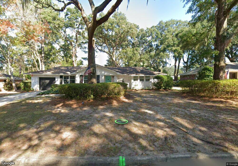
120 Talbot Rd Savannah, GA 31410
Estimated Value: $446,000 - $491,000
3
Beds
2
Baths
1,594
Sq Ft
$289/Sq Ft
Est. Value
About This Home
This home is located at 120 Talbot Rd, Savannah, GA 31410 and is currently estimated at $461,196, approximately $289 per square foot. 120 Talbot Rd is a home located in Chatham County with nearby schools including Howard Elementary School, Coastal Middle School, and Islands High School.
Ownership History
Date
Name
Owned For
Owner Type
Purchase Details
Closed on
Mar 3, 2017
Sold by
Boyd Nancy S
Bought by
Brennan Lauren B and Sikes Gabrielle Diane
Current Estimated Value
Home Financials for this Owner
Home Financials are based on the most recent Mortgage that was taken out on this home.
Original Mortgage
$216,000
Outstanding Balance
$179,218
Interest Rate
4.19%
Mortgage Type
New Conventional
Estimated Equity
$281,978
Purchase Details
Closed on
May 2, 2007
Sold by
Not Provided
Bought by
Boyd Nancy S
Create a Home Valuation Report for This Property
The Home Valuation Report is an in-depth analysis detailing your home's value as well as a comparison with similar homes in the area
Home Values in the Area
Average Home Value in this Area
Purchase History
| Date | Buyer | Sale Price | Title Company |
|---|---|---|---|
| Brennan Lauren B | $240,000 | -- | |
| Boyd Nancy S | $199,900 | -- |
Source: Public Records
Mortgage History
| Date | Status | Borrower | Loan Amount |
|---|---|---|---|
| Open | Brennan Lauren B | $216,000 |
Source: Public Records
Tax History
| Year | Tax Paid | Tax Assessment Tax Assessment Total Assessment is a certain percentage of the fair market value that is determined by local assessors to be the total taxable value of land and additions on the property. | Land | Improvement |
|---|---|---|---|---|
| 2025 | $3,004 | $157,400 | $27,720 | $129,680 |
| 2024 | $22 | $121,000 | $27,720 | $93,280 |
| 2023 | $2,192 | $111,200 | $27,720 | $83,480 |
| 2022 | $2,607 | $103,280 | $27,720 | $75,560 |
| 2021 | $2,708 | $85,120 | $27,720 | $57,400 |
| 2020 | $2,620 | $84,800 | $27,720 | $57,080 |
| 2019 | $2,740 | $84,800 | $27,720 | $57,080 |
| 2018 | $2,599 | $83,840 | $27,720 | $56,120 |
| 2017 | $2,557 | $77,000 | $27,720 | $49,280 |
| 2016 | $2,635 | $76,760 | $27,720 | $49,040 |
| 2015 | $2,702 | $78,640 | $27,720 | $50,920 |
| 2014 | $4,119 | $82,120 | $0 | $0 |
Source: Public Records
Map
Nearby Homes
- 116 Steerforth Rd
- 11 Mary Musgrove Dr
- 113 Suffolk Rd
- 311 Pickwick Rd
- 127 Druid Cir
- 35 Clarendon Rd
- 214 Island Creek Ln
- 230 Island Creek Ln
- 313 Wellington Rd
- 1 Old Fort Way
- 103 Deerwood Rd
- 119 Farringdon Cir
- 129 Stafford Rd
- 207 Devonshire Rd
- 209 Deerwood Rd
- 2 Landon Ln
- 103 W Gazebo Ln
- 105 Montford Ct
- 401 N Cromwell Rd Unit Q7
- 401 N Cromwell Rd Unit F-5
- 118 Talbot Rd
- 122 Talbot Rd
- 117 Steerforth Rd
- 119 Steerforth Rd
- 119 Talbot Rd
- 115 Steerforth Rd
- 116 Talbot Rd
- 117 Talbot Rd
- 130 Hampshire Rd
- 121 Talbot Rd
- 115 Talbot Rd
- 113 Steerforth Rd
- 114 Talbot Rd
- 123 Talbot Rd
- 120 Hampshire Rd
- 113 Talbot Rd
- 122 Hampshire Rd
- 118 Steerforth Rd
- 120 Steerforth Rd
- 118 Hampshire Rd
Your Personal Tour Guide
Ask me questions while you tour the home.