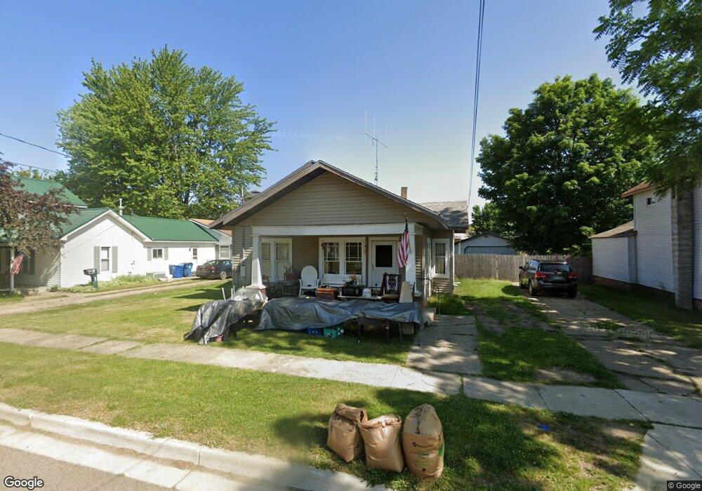
120 W Corey St Bronson, MI 49028
Estimated Value: $126,672 - $786,000
2
Beds
--
Bath
1,200
Sq Ft
$253/Sq Ft
Est. Value
About This Home
This home is located at 120 W Corey St, Bronson, MI 49028 and is currently estimated at $303,668, approximately $253 per square foot. 120 W Corey St is a home located in Branch County with nearby schools including Anderson Elementary School, Ryan Elementary School, and Bronson Junior/Senior High School.
Ownership History
Date
Name
Owned For
Owner Type
Purchase Details
Closed on
Oct 24, 2024
Sold by
Roberts Gracelynn Anne and Roberts Noah
Bought by
Pignataro Alan and Pignataro Tina
Current Estimated Value
Purchase Details
Closed on
Mar 5, 2024
Sold by
Quicken Loans Inc
Bought by
Roberts Gracelynn Anne
Purchase Details
Closed on
Jan 11, 2024
Sold by
Branch County
Bought by
Quicken Loans Inc and Lipke
Purchase Details
Closed on
Sep 8, 2006
Sold by
Slack Katherine K
Bought by
Lipke Frank L and Lipke Sharon S
Create a Home Valuation Report for This Property
The Home Valuation Report is an in-depth analysis detailing your home's value as well as a comparison with similar homes in the area
Home Values in the Area
Average Home Value in this Area
Purchase History
| Date | Buyer | Sale Price | Title Company |
|---|---|---|---|
| Pignataro Alan | $660,000 | None Listed On Document | |
| Roberts Gracelynn Anne | $75,900 | None Listed On Document | |
| Quicken Loans Inc | $73,800 | None Listed On Document | |
| Lipke Frank L | -- | None Available |
Source: Public Records
Tax History Compared to Growth
Tax History
| Year | Tax Paid | Tax Assessment Tax Assessment Total Assessment is a certain percentage of the fair market value that is determined by local assessors to be the total taxable value of land and additions on the property. | Land | Improvement |
|---|---|---|---|---|
| 2025 | $1,207 | $65,500 | $0 | $0 |
| 2024 | $757 | $64,600 | $0 | $0 |
| 2023 | $705 | $51,000 | $0 | $0 |
| 2022 | $1,115 | $43,500 | $0 | $0 |
| 2021 | -- | $40,100 | $0 | $0 |
| 2020 | -- | $35,800 | $0 | $0 |
| 2019 | -- | $32,000 | $0 | $0 |
| 2018 | -- | $26,900 | $0 | $0 |
| 2017 | -- | $26,300 | $0 | $0 |
| 2016 | -- | $26,500 | $0 | $0 |
| 2015 | -- | $24,000 | $0 | $0 |
| 2014 | -- | $22,700 | $0 | $0 |
| 2013 | -- | $25,600 | $0 | $0 |
Source: Public Records
Map
Nearby Homes
- 230 Compton St
- 227 York St
- 151 E Corey St
- 505 W Chicago St
- 313 N Matteson St
- 337 N Walker St
- 410 Franklin St
- 150 Washington St
- 644 S Matteson St
- 544 E Chicago St
- 325 N Lincoln St
- 926 Weaver Rd
- 688 W Chicago Rd
- 389 Prairie River Rd
- 769 Kosmerick Rd
- 0 Bawden Rd
- 130 Osborn Rd
- 1052 Carpenter Rd
- 1015 Brink Rd
- 141 S Snow Prairie Rd
- 128 W Corey St
- 114 W Corey St
- 134 W Corey St
- 119 W Corey St
- 125 W Corey St
- 142 S Matteson St
- 135 W Corey St
- 204 S Matteson St
- 206 S Matteson St
- 210 S Matteson St
- 139 W Corey St
- 214 S Matteson St
- 207 S Walker St
- 119 W Chicago St
- 120 S Matteson St
- 222 S Matteson St
- 122 Compton St
- 113 W Chicago St
- 128 Compton St
- 120 S Matteson St