Estimated Value: $210,897 - $261,000
3
Beds
1
Bath
1,406
Sq Ft
$164/Sq Ft
Est. Value
About This Home
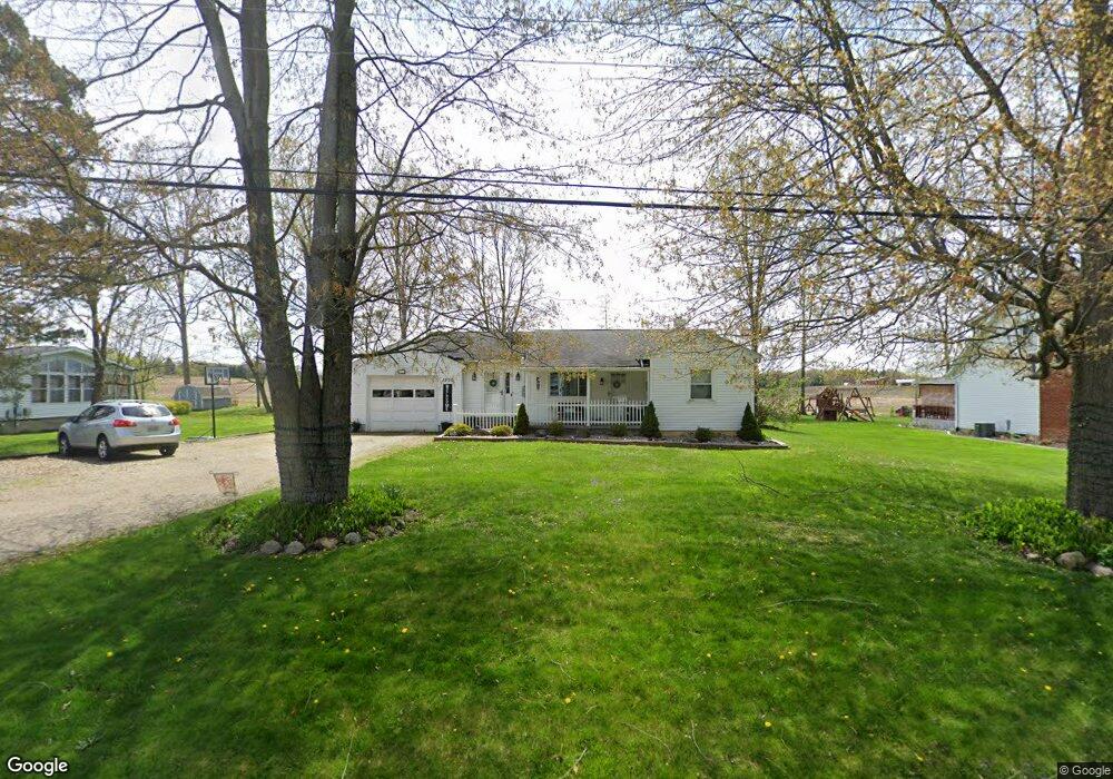
This home is located at 1200 Morrow Rd, Kent, OH 44240 and is currently estimated at $229,974, approximately $163 per square foot. 1200 Morrow Rd is a home located in Portage County with nearby schools including Brimfield Elementary School, Field Middle School, and Field High School.
Ownership History
Date
Name
Owned For
Owner Type
Purchase Details
Closed on
Mar 9, 2023
Sold by
Derrit Robert M
Bought by
Robert M Derrit Revocable Trust
Current Estimated Value
Purchase Details
Closed on
Feb 1, 2019
Sold by
Derrit Robert M
Bought by
Derrit Robert O and Derrit Donna M
Home Financials for this Owner
Home Financials are based on the most recent Mortgage that was taken out on this home.
Original Mortgage
$119,300
Interest Rate
4.4%
Mortgage Type
Land Contract Argmt. Of Sale
Purchase Details
Closed on
May 28, 2008
Sold by
Lenart Lynn M
Bought by
Derrit Robert M
Home Financials for this Owner
Home Financials are based on the most recent Mortgage that was taken out on this home.
Original Mortgage
$95,000
Interest Rate
5.87%
Mortgage Type
Purchase Money Mortgage
Purchase Details
Closed on
May 9, 1995
Sold by
Davis Mae V
Bought by
Lynn M Lenart
Home Financials for this Owner
Home Financials are based on the most recent Mortgage that was taken out on this home.
Original Mortgage
$74,200
Interest Rate
8.43%
Mortgage Type
New Conventional
Create a Home Valuation Report for This Property
The Home Valuation Report is an in-depth analysis detailing your home's value as well as a comparison with similar homes in the area
Home Values in the Area
Average Home Value in this Area
Purchase History
| Date | Buyer | Sale Price | Title Company |
|---|---|---|---|
| Robert M Derrit Revocable Trust | -- | -- | |
| Derrit Robert O | -- | None Available | |
| Derrit Robert M | $118,900 | Attorney | |
| Lynn M Lenart | $76,500 | -- |
Source: Public Records
Mortgage History
| Date | Status | Borrower | Loan Amount |
|---|---|---|---|
| Previous Owner | Derrit Robert O | $119,300 | |
| Previous Owner | Derrit Robert M | $95,000 | |
| Previous Owner | Lynn M Lenart | $74,200 |
Source: Public Records
Tax History
| Year | Tax Paid | Tax Assessment Tax Assessment Total Assessment is a certain percentage of the fair market value that is determined by local assessors to be the total taxable value of land and additions on the property. | Land | Improvement |
|---|---|---|---|---|
| 2024 | $4,011 | $70,740 | $13,270 | $57,470 |
| 2023 | $3,736 | $52,580 | $11,590 | $40,990 |
| 2022 | $3,745 | $52,580 | $11,590 | $40,990 |
| 2021 | $3,653 | $52,580 | $11,590 | $40,990 |
| 2020 | $3,470 | $44,910 | $11,590 | $33,320 |
| 2019 | $3,459 | $44,910 | $11,590 | $33,320 |
| 2018 | $2,918 | $40,430 | $11,590 | $28,840 |
| 2017 | $2,796 | $40,430 | $11,590 | $28,840 |
| 2016 | $2,762 | $40,430 | $11,590 | $28,840 |
Source: Public Records
Map
Nearby Homes
- 1386 Brookdale Ln
- 3532 Gary Dr
- 3517 Jameson Dr
- 3880 Selnik Rd
- 3483 Lawndale Dr
- 3929 Lor Ron St
- 3793 Ranfield Rd
- 4360 Beal Dr
- 3910 Willow Way
- 4088 Lynwood Dr
- 4545 State Route 43
- 1556 Saxe Rd
- 788 Cambridge Ct
- 4595 Creekside Dr
- 0 Newton Unit 5174619
- 124 Tallmadge Rd
- 112 Tallmadge Rd
- 496 Helena Dr
- 0 Progress Blvd Unit LotWP001
- 4808 Sherman Rd
- 1190 Morrow Rd
- 1220 Morrow Rd
- 1180 Morrow Rd
- 1197 Morrow Rd
- 1187 Morrow Rd
- 1217 Morrow Rd
- 1170 Morrow Rd
- 1227 Morrow Rd
- 1228 Morrow Rd
- 1206 Meadowview Rd
- 1186 Meadowview Rd
- 1216 Meadowview Rd
- 1165 Morrow Rd
- 1160 Morrow Rd
- 1196 Meadowview Rd
- 1176 Meadowview Rd
- 3667 Morrow Rd
- 3652 Morrow Rd
- 1164 Morrow Rd
- 999999 Morrow Rd
Your Personal Tour Guide
Ask me questions while you tour the home.