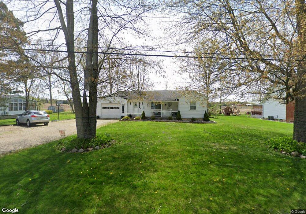
1200 Morrow Rd Kent, OH 44240
Brimfield AreaEstimated Value: $227,180 - $256,000
About This Home
This home is located at 1200 Morrow Rd, Kent, OH 44240 and is currently estimated at $241,795, approximately $171 per square foot. 1200 Morrow Rd is a home located in Portage County with nearby schools including Brimfield Elementary School, Field Middle School, and Field High School.
Ownership History
We collect this data history from publicly available records. To have your information removed, we recommend requesting removal directly through your county’s website.
Purchase Details
Purchase Details
Purchase Details
Home Financials for this Owner
Home Financials are based on the most recent Mortgage that was taken out on this home.Home Values in the Area
Average Home Value in this Area
Purchase History
We collect this data history from publicly available records. To have your information removed, we recommend requesting removal directly through your county’s website.
| Date | Buyer | Sale Price | Title Company |
|---|---|---|---|
| -- | -- | ||
| -- | None Available | ||
| $118,900 | Attorney |
Mortgage History
We collect this data history from publicly available records. To have your information removed, we recommend requesting removal directly through your county’s website.
| Date | Status | Borrower | Loan Amount |
|---|---|---|---|
| Previous Owner | $95,000 |
Tax History
We collect this data history from publicly available records. To have your information removed, we recommend requesting removal directly through your county’s website.
| Year | Tax Paid | Tax Assessment Tax Assessment Total Assessment is a certain percentage of the fair market value that is determined by local assessors to be the total taxable value of land and additions on the property. | Land | Improvement |
|---|---|---|---|---|
| 2025 | $4,107 | $70,740 | $13,270 | $57,470 |
| 2024 | $4,011 | $70,740 | $13,270 | $57,470 |
| 2023 | $3,736 | $52,580 | $11,590 | $40,990 |
| 2022 | $3,745 | $52,580 | $11,590 | $40,990 |
| 2021 | $3,653 | $52,580 | $11,590 | $40,990 |
| 2020 | $3,470 | $44,910 | $11,590 | $33,320 |
| 2019 | $3,459 | $44,910 | $11,590 | $33,320 |
| 2018 | $2,918 | $40,430 | $11,590 | $28,840 |
| 2017 | $2,796 | $40,430 | $11,590 | $28,840 |
| 2016 | $2,762 | $40,430 | $11,590 | $28,840 |
| 2015 | $2,707 | $40,430 | $11,590 | $28,840 |
| 2014 | $2,564 | $39,070 | $11,590 | $27,480 |
| 2013 | $2,510 | $39,070 | $11,590 | $27,480 |
Map
- 3659 Morrow Rd
- 3800 Grace Dr
- 1437 Old Forge Rd
- 890 Irish Rd
- 3941 Grace Dr
- 4118 Pembroke Dr
- 2981 Reservoir Dr
- 1121 Doralee Dr
- 4360 Beal Dr
- 4028 Willow Way
- 4148 Sherman Rd
- 4469 Edson Rd
- 4328 Sunnybrook Rd
- 4713 Sherman Rd
- 124 Tallmadge Rd
- 1835 Lynn Rd
- 112 Tallmadge Rd
- 44 Westminster Ln
- 60 Picadilly Ct Unit 7A
- 406 Washburn Rd
- 1190 Morrow Rd
- 1180 Morrow Rd
- 1220 Morrow Rd
- 1197 Morrow Rd
- 1187 Morrow Rd
- 1217 Morrow Rd
- 1170 Morrow Rd
- 1227 Morrow Rd
- 1228 Morrow Rd
- 1206 Meadowview Rd
- 1186 Meadowview Rd
- 1216 Meadowview Rd
- 1165 Morrow Rd
- 1160 Morrow Rd
- 1196 Meadowview Rd
- 1176 Meadowview Rd
- 3667 Morrow Rd
- 1232 Morrow Rd
- 3652 Morrow Rd
- 1164 Morrow Rd
Ask me questions while you tour the home.