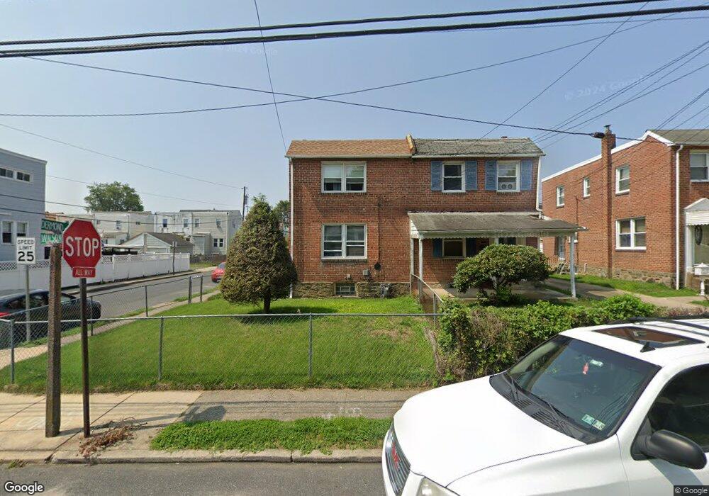
1200 Wilson Dr Havertown, PA 19083
Estimated Value: $258,241 - $283,000
3
Beds
1
Bath
1,156
Sq Ft
$236/Sq Ft
Est. Value
About This Home
This home is located at 1200 Wilson Dr, Havertown, PA 19083 and is currently estimated at $272,310, approximately $235 per square foot. 1200 Wilson Dr is a home located in Delaware County with nearby schools including Hillcrest El School, Drexel Hill Middle School, and Upper Darby High School.
Ownership History
Date
Name
Owned For
Owner Type
Purchase Details
Closed on
Sep 8, 1997
Sold by
Thompson Harold K and Thompson Maria L
Bought by
Coduto Mario M
Current Estimated Value
Home Financials for this Owner
Home Financials are based on the most recent Mortgage that was taken out on this home.
Original Mortgage
$99,949
Outstanding Balance
$15,272
Interest Rate
7.31%
Mortgage Type
FHA
Estimated Equity
$257,038
Create a Home Valuation Report for This Property
The Home Valuation Report is an in-depth analysis detailing your home's value as well as a comparison with similar homes in the area
Home Values in the Area
Average Home Value in this Area
Purchase History
| Date | Buyer | Sale Price | Title Company |
|---|---|---|---|
| Coduto Mario M | $100,000 | Commonwealth Land Title Ins |
Source: Public Records
Mortgage History
| Date | Status | Borrower | Loan Amount |
|---|---|---|---|
| Open | Coduto Mario M | $99,949 |
Source: Public Records
Tax History Compared to Growth
Tax History
| Year | Tax Paid | Tax Assessment Tax Assessment Total Assessment is a certain percentage of the fair market value that is determined by local assessors to be the total taxable value of land and additions on the property. | Land | Improvement |
|---|---|---|---|---|
| 2025 | $5,394 | $127,540 | $27,320 | $100,220 |
| 2024 | $5,394 | $127,540 | $27,320 | $100,220 |
| 2023 | $5,343 | $127,540 | $27,320 | $100,220 |
| 2022 | $5,199 | $127,540 | $27,320 | $100,220 |
| 2021 | $7,011 | $127,540 | $27,320 | $100,220 |
| 2020 | $5,626 | $86,970 | $29,810 | $57,160 |
| 2019 | $5,527 | $86,970 | $29,810 | $57,160 |
| 2018 | $5,463 | $86,970 | $0 | $0 |
| 2017 | $5,321 | $86,970 | $0 | $0 |
| 2016 | $477 | $86,970 | $0 | $0 |
| 2015 | $477 | $86,970 | $0 | $0 |
| 2014 | $477 | $86,970 | $0 | $0 |
Source: Public Records
Map
Nearby Homes
- 1214 Roosevelt Dr
- 1114 Roosevelt Dr
- 1101 Wilson Dr
- 1133 Agnew Dr
- 1237 Bryan St
- 1228 Bryan St
- 1228 Old Ln
- 1025 Shadeland Ave
- 2354 Bond Ave
- 924 Fairfax Rd
- 71 S Brighton Ave
- 8525 Monroe Ave
- 104 Gilmore Rd
- 872 Fairfax Rd
- 2219 Ardmore Ave
- 2548 Irvington Rd
- 1004 Turner Ave
- 858 Fairfax Rd
- 827 Hampshire Rd
- 110 E Township Line Rd
- 1202 Wilson Dr
- 1204 Wilson Dr
- 1206 Wilson Dr
- 1208 Wilson Dr
- 1201 Roosevelt Dr
- 1144 Wilson Dr
- 1203 Roosevelt Dr
- 1205 Roosevelt Dr
- 1210 Wilson Dr
- 1142 Wilson Dr
- 1207 Roosevelt Dr
- 1147 Roosevelt Dr
- 1209 Roosevelt Dr
- 1145 Roosevelt Dr
- 1212 Wilson Dr
- 1140 Wilson Dr
- 1203 Wilson Dr
- 1205 Wilson Dr
- 1201 Wilson Dr
- 1207 Wilson Dr