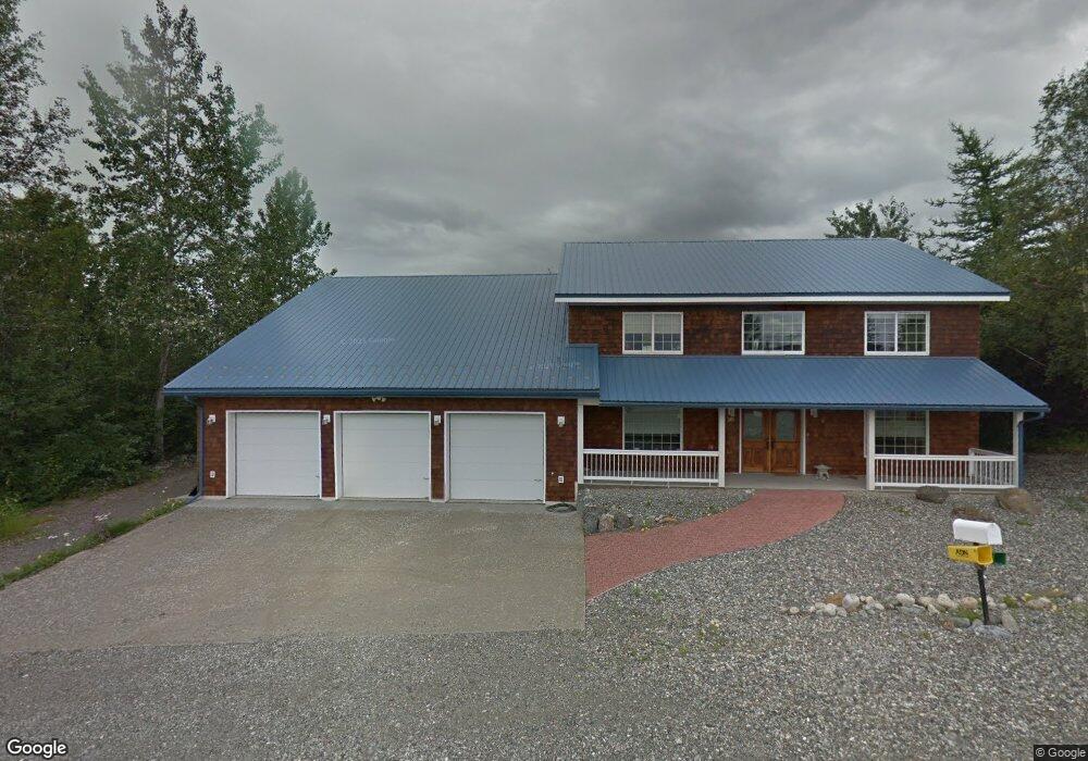
1201 S Westpoint Dr Wasilla, AK 99654
Estimated Value: $360,000 - $778,000
--
Bed
--
Bath
1,312
Sq Ft
$492/Sq Ft
Est. Value
About This Home
This home is located at 1201 S Westpoint Dr, Wasilla, AK 99654 and is currently estimated at $644,975, approximately $491 per square foot. 1201 S Westpoint Dr is a home located in Matanuska-Susitna Borough with nearby schools including Iditarod Elementary School, Wasilla Middle School, and Wasilla High School.
Ownership History
Date
Name
Owned For
Owner Type
Purchase Details
Closed on
Aug 16, 2018
Sold by
Mcmurran John A and Mcmurran Leaseia
Bought by
Lowe Sandra Marie and Lowe Noel H
Current Estimated Value
Home Financials for this Owner
Home Financials are based on the most recent Mortgage that was taken out on this home.
Original Mortgage
$378,000
Outstanding Balance
$328,278
Interest Rate
4.5%
Mortgage Type
New Conventional
Estimated Equity
$316,697
Create a Home Valuation Report for This Property
The Home Valuation Report is an in-depth analysis detailing your home's value as well as a comparison with similar homes in the area
Home Values in the Area
Average Home Value in this Area
Purchase History
| Date | Buyer | Sale Price | Title Company |
|---|---|---|---|
| Lowe Sandra Marie | -- | None Available |
Source: Public Records
Mortgage History
| Date | Status | Borrower | Loan Amount |
|---|---|---|---|
| Open | Lowe Sandra Marie | $378,000 |
Source: Public Records
Tax History Compared to Growth
Tax History
| Year | Tax Paid | Tax Assessment Tax Assessment Total Assessment is a certain percentage of the fair market value that is determined by local assessors to be the total taxable value of land and additions on the property. | Land | Improvement |
|---|---|---|---|---|
| 2025 | $7,634 | $731,000 | $88,000 | $643,000 |
| 2024 | $7,634 | $720,600 | $88,000 | $632,600 |
| 2023 | $7,253 | $704,400 | $88,000 | $616,400 |
| 2022 | $6,964 | $641,800 | $88,000 | $553,800 |
| 2021 | $6,989 | $578,000 | $88,000 | $490,000 |
| 2020 | $6,791 | $544,500 | $88,000 | $456,500 |
| 2019 | $6,645 | $530,100 | $88,000 | $442,100 |
| 2018 | $6,508 | $521,400 | $88,000 | $433,400 |
| 2017 | $3,736 | $517,300 | $88,000 | $429,300 |
| 2016 | $3,634 | $517,500 | $88,000 | $429,500 |
| 2015 | $3,461 | $486,300 | $78,000 | $408,300 |
| 2014 | $3,461 | $466,400 | $78,000 | $388,400 |
Source: Public Records
Map
Nearby Homes
- 1072 E Westpoint Dr Unit 6
- 985 E Usa Cir
- 510 E Bogard Rd
- NHN S Roberts St
- 1000 E Dellwood St
- 900 E Horvath Dr
- L6 B2 Bella Ridge Subdivision
- L5 Sassy Lot 5 B2
- 1906 W Cashatt Ave
- 3669 S Alvaro Dr
- 15151 W Crest Place
- 3637 S Alvaro Dr
- 1141 N Elsinore Ave
- 1181 N Elsinore Ave
- 460 S August Cir
- 701 New Maney Dr
- 1796 E Neil Cir Unit 3
- 121 E Herning Ave
- 1840 E Totem Rd
- 1331 N Tanana Dr
- 1225 E Westpoint Dr
- 1201 E Westpoint Dr
- 1191 E Westpoint Dr
- 1191 E Westpoint Dr Unit 2
- 1220 E Westpoint Dr
- 1200 E Westpoint Dr
- 1245 E Westpoint Dr
- 1167 E Westpoint Dr Unit 3
- 1167 E Westpoint Dr
- 1167 E Westpoint Dr Unit 2
- 1167 E Westpoint Dr Unit 1
- 1167 E Westpoint Dr Unit 2
- 1167 E Westpoint Dr Unit 3
- 1167 E Westpoint Dr
- 1190 E Westpoint Dr
- 1240 E Westpoint Dr
- 1260 E Westpoint Dr
- 401 N Westcove Dr
- 1165 E Westpoint Dr Unit 1
- 1165 E Westpoint Dr Unit 2