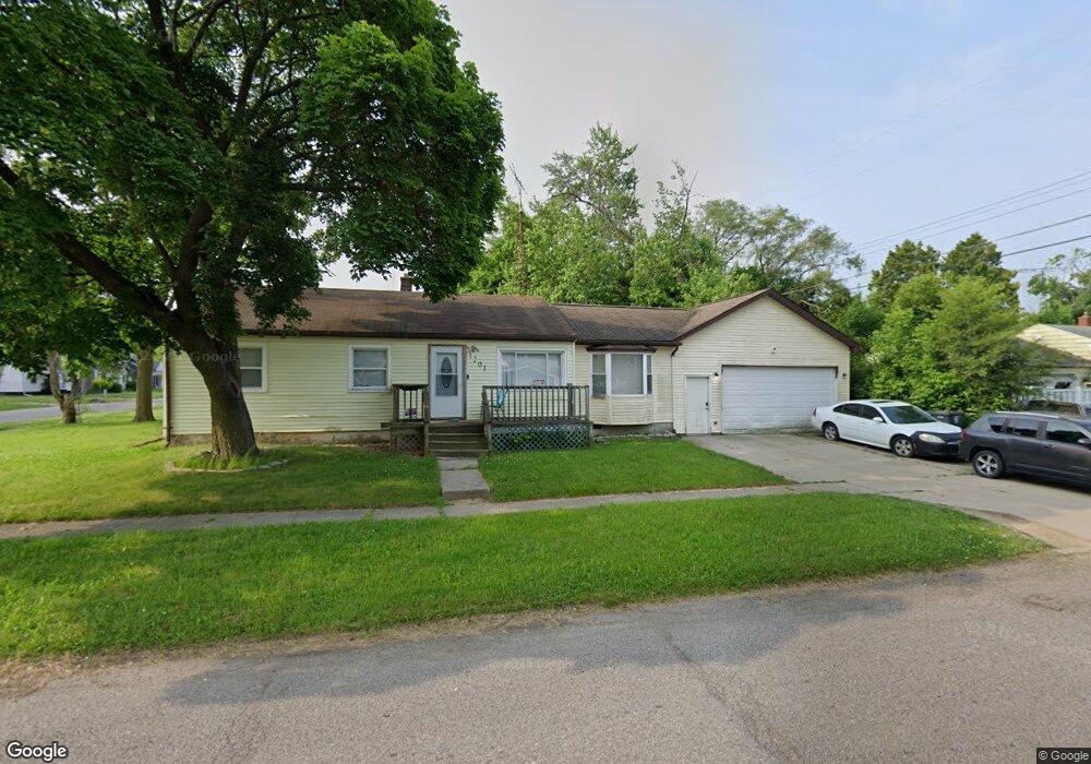
1201 W Mott Ave Flint, MI 48505
Bel-Aire Woods NeighborhoodEstimated Value: $54,000 - $76,000
3
Beds
1
Bath
1,271
Sq Ft
$47/Sq Ft
Est. Value
About This Home
This home is located at 1201 W Mott Ave, Flint, MI 48505 and is currently estimated at $60,137, approximately $47 per square foot. 1201 W Mott Ave is a home located in Genesee County with nearby schools including Brownell STEM Academy, The New Standard Academy, and Eagle's Nest Academy.
Ownership History
Date
Name
Owned For
Owner Type
Purchase Details
Closed on
Oct 26, 2022
Sold by
Genesee County Land Bank Authority
Bought by
Grant Dominika Rochelle and Veasey Joseph Elijah
Current Estimated Value
Purchase Details
Closed on
Aug 21, 2018
Sold by
Genesse County Land Bank Authority
Bought by
Grant Dominika Rochelle and Veasey Joseph Elijah
Home Financials for this Owner
Home Financials are based on the most recent Mortgage that was taken out on this home.
Original Mortgage
$5,000
Interest Rate
4.5%
Mortgage Type
Purchase Money Mortgage
Purchase Details
Closed on
Dec 20, 2017
Sold by
Cherry Deborah L
Bought by
Genesee County Bank
Purchase Details
Closed on
Aug 20, 2015
Sold by
Estate Of Elanor Carr
Bought by
Cummings Faith
Create a Home Valuation Report for This Property
The Home Valuation Report is an in-depth analysis detailing your home's value as well as a comparison with similar homes in the area
Home Values in the Area
Average Home Value in this Area
Purchase History
| Date | Buyer | Sale Price | Title Company |
|---|---|---|---|
| Grant Dominika Rochelle | $6,000 | -- | |
| Grant Dominika Rochelle | $6,000 | None Available | |
| Genesee County Bank | -- | None Available | |
| Cummings Faith | -- | None Available |
Source: Public Records
Mortgage History
| Date | Status | Borrower | Loan Amount |
|---|---|---|---|
| Previous Owner | Grant Dominika Rochelle | $5,000 |
Source: Public Records
Tax History Compared to Growth
Tax History
| Year | Tax Paid | Tax Assessment Tax Assessment Total Assessment is a certain percentage of the fair market value that is determined by local assessors to be the total taxable value of land and additions on the property. | Land | Improvement |
|---|---|---|---|---|
| 2025 | $960 | $23,000 | $0 | $0 |
| 2024 | $871 | $20,700 | $0 | $0 |
| 2023 | $856 | $19,400 | $0 | $0 |
| 2022 | $0 | $14,000 | $0 | $0 |
| 2021 | $889 | $13,400 | $0 | $0 |
| 2020 | $803 | $11,300 | $0 | $0 |
| 2019 | $788 | $11,200 | $0 | $0 |
| 2018 | $1,099 | $0 | $0 | $0 |
| 2017 | $1,614 | $0 | $0 | $0 |
| 2016 | $1,055 | $0 | $0 | $0 |
| 2015 | -- | $0 | $0 | $0 |
| 2014 | -- | $0 | $0 | $0 |
| 2012 | -- | $17,100 | $0 | $0 |
Source: Public Records
Map
Nearby Homes
- 5302 Susan St
- 5610 Baldwin Blvd
- 5318 Baldwin Blvd
- 1720 Marlowe Dr
- 5616 Griggs Dr
- 1902 Marlowe Dr
- 1621 Shamrock Ln
- 5210 Dupont St
- 5620 Marlowe Dr
- 1605 Barbara Dr
- 5806 Marlowe Dr
- 1709 W Home Ave
- 5714 Suburban Ct
- 1625 Barbara Dr
- 4808 Edwards Ave
- 536 W Home Ave
- 609 W Marengo Ave
- 5106 Cloverlawn Dr
- 525 W Pulaski Ave
- 6628 Orange Ln