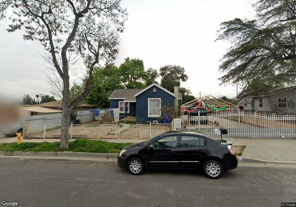
12011 Laurel Ave Whittier, CA 90605
South Whittier NeighborhoodEstimated Value: $835,000 - $1,029,000
4
Beds
2
Baths
1,761
Sq Ft
$537/Sq Ft
Est. Value
About This Home
This home is located at 12011 Laurel Ave, Whittier, CA 90605 and is currently estimated at $946,397, approximately $537 per square foot. 12011 Laurel Ave is a home located in Los Angeles County with nearby schools including California High School and St. Gregory The Great.
Ownership History
Date
Name
Owned For
Owner Type
Purchase Details
Closed on
Mar 10, 2004
Sold by
Moreno Juan and Moreno Maria R
Bought by
Paredes Florencio
Current Estimated Value
Home Financials for this Owner
Home Financials are based on the most recent Mortgage that was taken out on this home.
Original Mortgage
$320,000
Interest Rate
5.5%
Mortgage Type
Purchase Money Mortgage
Create a Home Valuation Report for This Property
The Home Valuation Report is an in-depth analysis detailing your home's value as well as a comparison with similar homes in the area
Home Values in the Area
Average Home Value in this Area
Purchase History
| Date | Buyer | Sale Price | Title Company |
|---|---|---|---|
| Paredes Florencio | $400,000 | Chicago Title |
Source: Public Records
Mortgage History
| Date | Status | Borrower | Loan Amount |
|---|---|---|---|
| Previous Owner | Paredes Florencio | $320,000 | |
| Closed | Paredes Florencio | $80,000 |
Source: Public Records
Tax History Compared to Growth
Tax History
| Year | Tax Paid | Tax Assessment Tax Assessment Total Assessment is a certain percentage of the fair market value that is determined by local assessors to be the total taxable value of land and additions on the property. | Land | Improvement |
|---|---|---|---|---|
| 2025 | $7,329 | $568,699 | $383,874 | $184,825 |
| 2024 | $7,329 | $557,549 | $376,348 | $181,201 |
| 2023 | $6,937 | $546,618 | $368,969 | $177,649 |
| 2022 | $6,987 | $535,901 | $361,735 | $174,166 |
| 2021 | $6,844 | $525,394 | $354,643 | $170,751 |
| 2020 | $6,772 | $520,008 | $351,007 | $169,001 |
| 2019 | $6,727 | $509,813 | $344,125 | $165,688 |
| 2018 | $6,477 | $499,818 | $337,378 | $162,440 |
| 2016 | $6,163 | $480,411 | $324,278 | $156,133 |
| 2015 | $6,010 | $473,196 | $319,408 | $153,788 |
| 2014 | $5,956 | $463,928 | $313,152 | $150,776 |
Source: Public Records
Map
Nearby Homes
- 11828 Louis Ave
- 13272 Beaty Ave
- 13213 Leffingwell Rd
- 11820 Painter Ave
- 13513 Leffingwell Rd
- 13481 Meyer Rd
- 11518 Fidel Ave
- 11428 Painter Ave
- 13531 Utica St
- 13538 Lukay St
- 13703 Placid Dr
- 12309 Ramsey Dr
- 11116 Leland Ave
- 13071 Miller Ave
- 13857 Leffingwell Rd
- 10849 Inez St
- 12818 Duffield Ave
- 12947 Foster Rd
- 13007 Duffield Ave
- 13854 Adoree St
- 12003 Laurel Ave
- 13235 Sunshine Ave
- 13231 Sunshine Ave
- 13241 Sunshine Ave
- 13225 Sunshine Ave
- 12022 Fidel Ave
- 12000 Fidel Ave
- 11927 Laurel Ave
- 12012 Fidel Ave
- 12010 Fidel Ave
- 11928 Fidel Ave
- 11923 Laurel Ave
- 13219 Sunshine Ave
- 12026 Fidel Ave
- 12020 Fidel Ave
- 12105 Laurel Ave
- 12010 Laurel Ave
- 12002 Fidel Ave
- 12014 Laurel Ave
- 12002 Laurel Ave