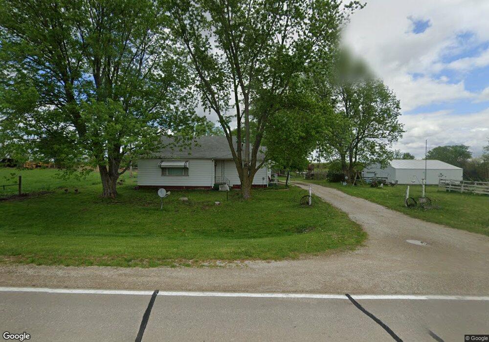
1202 280th Ave West Point, IA 52656
Estimated Value: $131,000 - $165,000
2
Beds
1
Bath
1,128
Sq Ft
$136/Sq Ft
Est. Value
About This Home
This home is located at 1202 280th Ave, West Point, IA 52656 and is currently estimated at $153,070, approximately $135 per square foot. 1202 280th Ave is a home located in Lee County with nearby schools including Fort Madison High School.
Ownership History
Date
Name
Owned For
Owner Type
Purchase Details
Closed on
Aug 25, 2023
Sold by
Brown Ronald D and Brown Sherrie L
Bought by
Miller Terry L and Miller Cynthia K
Current Estimated Value
Home Financials for this Owner
Home Financials are based on the most recent Mortgage that was taken out on this home.
Original Mortgage
$117,000
Outstanding Balance
$114,369
Interest Rate
6.88%
Mortgage Type
New Conventional
Estimated Equity
$38,702
Create a Home Valuation Report for This Property
The Home Valuation Report is an in-depth analysis detailing your home's value as well as a comparison with similar homes in the area
Home Values in the Area
Average Home Value in this Area
Purchase History
| Date | Buyer | Sale Price | Title Company |
|---|---|---|---|
| Miller Terry L | $130,000 | None Listed On Document | |
| Miller Terry L | $130,000 | None Listed On Document |
Source: Public Records
Mortgage History
| Date | Status | Borrower | Loan Amount |
|---|---|---|---|
| Open | Miller Terry L | $117,000 | |
| Closed | Miller Terry L | $117,000 |
Source: Public Records
Tax History Compared to Growth
Tax History
| Year | Tax Paid | Tax Assessment Tax Assessment Total Assessment is a certain percentage of the fair market value that is determined by local assessors to be the total taxable value of land and additions on the property. | Land | Improvement |
|---|---|---|---|---|
| 2025 | $1,582 | $137,500 | $29,830 | $107,670 |
| 2024 | $1,582 | $121,030 | $29,830 | $91,200 |
| 2023 | $1,218 | $121,030 | $29,830 | $91,200 |
| 2022 | $1,492 | $89,020 | $25,450 | $63,570 |
| 2021 | $1,492 | $122,920 | $25,450 | $97,470 |
| 2020 | $1,524 | $117,190 | $26,980 | $90,210 |
| 2019 | $1,474 | $117,190 | $26,980 | $90,210 |
| 2018 | $1,526 | $110,550 | $0 | $0 |
| 2017 | $1,526 | $92,340 | $0 | $0 |
| 2016 | $1,194 | $92,340 | $0 | $0 |
| 2015 | $1,194 | $88,390 | $0 | $0 |
| 2014 | $1,156 | $88,390 | $0 | $0 |
Source: Public Records
Map
Nearby Homes
- 809 Houston Ave
- 10161 Jimtown Rd
- 5164 Augusta Main Rd
- 2532 305th St
- 910 Avenue D
- 406 Center St
- 203 & 205-207 Center St
- 210 Louisiana St
- 208 Louisiana St
- 200 Louisiana St
- 3035 New London Rd
- 2280 Windmill Way
- 2042 St Paul 2nd St
- 1684 345th Ave
- 1910 S Highway 61
- 2257 Burt Rd
- 74 A Green Bay Rd
- 14876 Washington Rd Unit 87
- 14876 Washington Rd Unit 136
- 14876 Washington Rd Unit 166