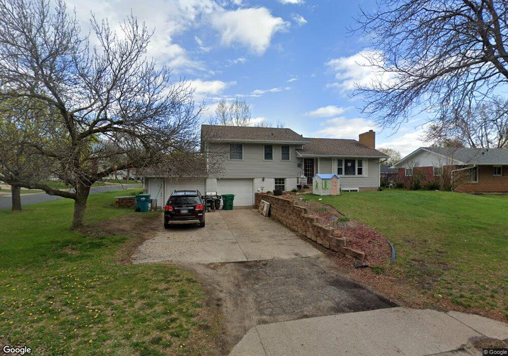
12025 Zion St NW Coon Rapids, MN 55433
Estimated Value: $314,457 - $330,000
4
Beds
2
Baths
1,140
Sq Ft
$281/Sq Ft
Est. Value
About This Home
This home is located at 12025 Zion St NW, Coon Rapids, MN 55433 and is currently estimated at $320,864, approximately $281 per square foot. 12025 Zion St NW is a home located in Anoka County with nearby schools including Lucile Bruner Elementary School, Morris Bye Elementary School, and Laughlin Junior/Senior High School.
Ownership History
Date
Name
Owned For
Owner Type
Purchase Details
Closed on
Oct 18, 2019
Sold by
Broome Vernon L and Broome Angela K
Bought by
Broome Vernon L and Broome Angela K
Current Estimated Value
Purchase Details
Closed on
Oct 20, 2009
Sold by
Hsbc Bank Usa
Bought by
Broome Vernon L and Broome Angela K
Create a Home Valuation Report for This Property
The Home Valuation Report is an in-depth analysis detailing your home's value as well as a comparison with similar homes in the area
Home Values in the Area
Average Home Value in this Area
Purchase History
| Date | Buyer | Sale Price | Title Company |
|---|---|---|---|
| Broome Vernon L | -- | None Available | |
| Broome Vernon L | $138,500 | -- |
Source: Public Records
Tax History Compared to Growth
Tax History
| Year | Tax Paid | Tax Assessment Tax Assessment Total Assessment is a certain percentage of the fair market value that is determined by local assessors to be the total taxable value of land and additions on the property. | Land | Improvement |
|---|---|---|---|---|
| 2025 | $2,970 | $289,900 | $84,000 | $205,900 |
| 2024 | $2,970 | $289,800 | $87,000 | $202,800 |
| 2023 | $2,949 | $284,300 | $76,000 | $208,300 |
| 2022 | $2,847 | $277,400 | $67,000 | $210,400 |
| 2021 | $2,649 | $238,200 | $67,000 | $171,200 |
| 2020 | $2,676 | $225,000 | $62,000 | $163,000 |
| 2019 | $2,496 | $218,300 | $60,000 | $158,300 |
| 2018 | $2,463 | $198,700 | $0 | $0 |
| 2017 | $2,106 | $190,600 | $0 | $0 |
| 2016 | $2,131 | $160,900 | $0 | $0 |
| 2015 | -- | $160,900 | $45,000 | $115,900 |
| 2014 | -- | $138,200 | $36,500 | $101,700 |
Source: Public Records
Map
Nearby Homes
- 12019 Zion St NW
- 11835 Crocus St NW
- 11809 Zion St NW
- 11749 Crooked Lake Blvd NW
- 3074 121st Ave NW
- 3020 117th Ave NW
- 2862 116th Ave NW
- 12189 Lily St NW
- 2675 128th Ave NW
- 2687 128th Ave NW
- 2068 124th Ln NW
- 2851 113th Ave NW
- 2147 125th Ln NW
- 11409 Quinn St NW
- 12597 Thrush St NW
- 11984 Orchid St NW
- 1830 121st Ln NW Unit 611
- 11444 Hanson Blvd NW
- 11424 Hanson Blvd NW
- 12760 Raven St NW
- 12027 Crocus St NW
- 12013 Zion St NW
- 12000 Crocus St NW
- 12012 Crocus St NW
- 11957 Crocus St NW
- 12024 Crocus St NW
- 11950 Crocus St NW
- 11980 Zion St NW
- 12039 Crocus St NW
- 12032 Crocus St NW
- 11949 Crocus St NW
- 12007 Zion St NW
- 11972 Zion St NW
- 11940 Crocus St NW
- 12051 Crocus St NW
- 12040 Crocus St NW
- 12001 Zion St NW
- 11971 Zion St NW
- 11941 Crocus St NW
- 12048 Crocus St NW