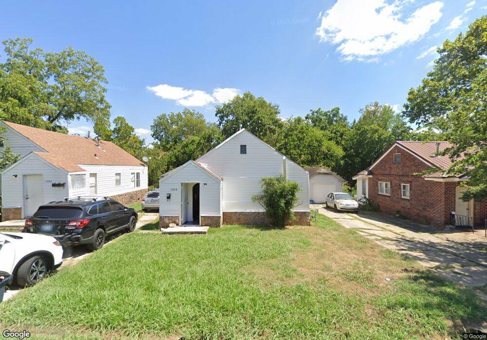
1203 N Oklahoma Ave Shawnee, OK 74801
Estimated Value: $72,000 - $145,000
4
Beds
2
Baths
1,516
Sq Ft
$64/Sq Ft
Est. Value
About This Home
This home is located at 1203 N Oklahoma Ave, Shawnee, OK 74801 and is currently estimated at $96,269, approximately $63 per square foot. 1203 N Oklahoma Ave is a home located in Pottawatomie County with nearby schools including Sequoyah Elementary School, Shawnee Middle School, and Shawnee High School.
Ownership History
Date
Name
Owned For
Owner Type
Purchase Details
Closed on
Aug 26, 2024
Sold by
Kristi Gibson Rental Property Llc
Bought by
B & S Home Rentals Llc
Current Estimated Value
Home Financials for this Owner
Home Financials are based on the most recent Mortgage that was taken out on this home.
Original Mortgage
$103,480
Outstanding Balance
$100,951
Interest Rate
6.77%
Mortgage Type
New Conventional
Estimated Equity
-$4,682
Purchase Details
Closed on
Mar 4, 2024
Sold by
C Leroy Jones 2006 Revocable Trust
Bought by
Kristi Gibson Rental Property Llc
Create a Home Valuation Report for This Property
The Home Valuation Report is an in-depth analysis detailing your home's value as well as a comparison with similar homes in the area
Home Values in the Area
Average Home Value in this Area
Purchase History
| Date | Buyer | Sale Price | Title Company |
|---|---|---|---|
| B & S Home Rentals Llc | $50,000 | First American Title Insurance | |
| Kristi Gibson Rental Property Llc | -- | None Listed On Document |
Source: Public Records
Mortgage History
| Date | Status | Borrower | Loan Amount |
|---|---|---|---|
| Open | B & S Home Rentals Llc | $103,480 |
Source: Public Records
Tax History Compared to Growth
Tax History
| Year | Tax Paid | Tax Assessment Tax Assessment Total Assessment is a certain percentage of the fair market value that is determined by local assessors to be the total taxable value of land and additions on the property. | Land | Improvement |
|---|---|---|---|---|
| 2024 | $482 | $4,848 | $518 | $4,330 |
| 2023 | $482 | $4,618 | $515 | $4,103 |
| 2022 | $451 | $4,398 | $510 | $3,888 |
| 2021 | $422 | $4,398 | $533 | $3,865 |
| 2020 | $403 | $3,989 | $480 | $3,509 |
| 2019 | $397 | $3,800 | $447 | $3,353 |
| 2018 | $370 | $3,618 | $425 | $3,193 |
| 2017 | $348 | $3,446 | $401 | $3,045 |
| 2016 | $335 | $3,282 | $352 | $2,930 |
| 2015 | $313 | $3,126 | $332 | $2,794 |
| 2014 | $298 | $2,977 | $610 | $2,367 |
Source: Public Records
Map
Nearby Homes
- 0 Independence and Minnesota St
- 1510 N Union Ave
- 1017 N Bdwy Ave
- 1003 N Minnesota Ave
- 434 E Wallace St
- 1217 N Market Ave
- 1602 N Bdwy
- 1712 N Pennsylvania Ave
- 1607 N Beard Ave
- 1006 N Market Ave
- 1822 N Phil Ave
- 1816 N Bell Ave
- 824 N Beard Ave
- 1324 N Park Ave
- 1817 N Bell Ave
- 727 N Beard Ave
- 717 N Broadway Ave
- 1901 N Bell Ave
- 907 N Mckinley Ave
- 000 N Mckinley Ave
- 1207 N Oklahoma Ave
- 1201 N Oklahoma Ave
- 1131 N Oklahoma Ave
- 1209 N Oklahoma Ave
- 304 E Milton St
- 1211 N Oklahoma Ave
- 1127 N Oklahoma Ave
- 11 E Park Dr
- 13 E Park Dr
- 1202 N Oklahoma Ave
- 405 E Scott St
- 305 E Milton St
- 15 E Park Dr
- 9 Park Dr
- 1204 N Oklahoma Ave
- 7 Park Dr
- 1123 N Oklahoma Ave
- 402 E Scott St
- 1228 N Oklahoma Ave
- 5 Park Dr