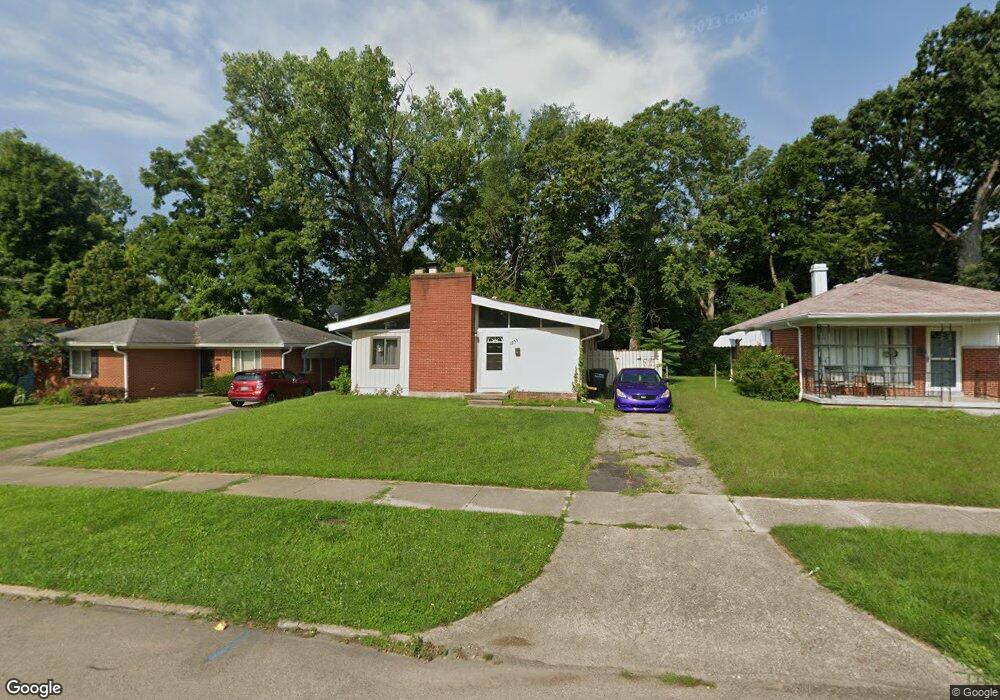
1203 Tennyson Ave Dayton, OH 45406
Cornell Heights NeighborhoodEstimated Value: $61,000 - $86,000
3
Beds
2
Baths
1,305
Sq Ft
$56/Sq Ft
Est. Value
About This Home
This home is located at 1203 Tennyson Ave, Dayton, OH 45406 and is currently estimated at $73,230, approximately $56 per square foot. 1203 Tennyson Ave is a home located in Montgomery County with nearby schools including Valerie Elementary School, Dayton Leadership Academies, and Imagine Klepinger Road Community School.
Ownership History
Date
Name
Owned For
Owner Type
Purchase Details
Closed on
Aug 25, 2021
Sold by
Oorr Investments Llc
Bought by
Star Direct Llc
Current Estimated Value
Purchase Details
Closed on
Aug 7, 2012
Sold by
Maxcap Investment Holdings Llc
Bought by
Oorr Investments Llc
Purchase Details
Closed on
Aug 26, 2011
Sold by
Springleaf Financial Services Of Ohio In
Bought by
Maxcap Investment Holdings Llc
Purchase Details
Closed on
Jul 12, 1994
Sold by
Bernt Russell and Bernt Gladys E
Bought by
Jackson Theda A
Create a Home Valuation Report for This Property
The Home Valuation Report is an in-depth analysis detailing your home's value as well as a comparison with similar homes in the area
Home Values in the Area
Average Home Value in this Area
Purchase History
| Date | Buyer | Sale Price | Title Company |
|---|---|---|---|
| Star Direct Llc | $42,000 | Team Title | |
| Oorr Investments Llc | $32,000 | Landmark Title Agency South | |
| Maxcap Investment Holdings Llc | $11,200 | Attorney | |
| Jackson Theda A | -- | -- |
Source: Public Records
Tax History Compared to Growth
Tax History
| Year | Tax Paid | Tax Assessment Tax Assessment Total Assessment is a certain percentage of the fair market value that is determined by local assessors to be the total taxable value of land and additions on the property. | Land | Improvement |
|---|---|---|---|---|
| 2024 | $590 | $9,950 | $3,290 | $6,660 |
| 2023 | $590 | $9,950 | $3,290 | $6,660 |
| 2022 | $650 | $8,510 | $2,810 | $5,700 |
| 2021 | $646 | $8,510 | $2,810 | $5,700 |
| 2020 | $645 | $8,510 | $2,810 | $5,700 |
| 2019 | $954 | $11,370 | $3,300 | $8,070 |
| 2018 | $956 | $11,370 | $3,300 | $8,070 |
| 2017 | $949 | $11,370 | $3,300 | $8,070 |
| 2016 | $1,058 | $12,120 | $3,300 | $8,820 |
| 2015 | $1,002 | $12,120 | $3,300 | $8,820 |
| 2014 | $1,002 | $12,120 | $3,300 | $8,820 |
| 2012 | -- | $17,270 | $4,100 | $13,170 |
Source: Public Records
Map
Nearby Homes
- 1312 Canfield Ave
- 1341 Shaftesbury Rd
- 1045 Philadelphia Dr
- 1365 Alcott Dr
- 1424 Shaftesbury Rd
- 1200 Wilson Dr
- 1812 Haverhill Dr
- 1233 Everett Dr
- 1460 Kipling Dr
- 620 Shoop Ave
- 2022 W Grand Ave
- 676 Brooklyn Ave
- 936 Walton Ave
- 559 Evergreen Ave
- 927 Maplehurst Ave
- 1643 Earlham Dr
- 1205 Windsor Ave
- 539 Evergreen Ave
- 1119 Windsor Ave
- 941 Leland Ave
- 1205 Tennyson Ave
- 1145 Tennyson Ave
- 1209 Tennyson Ave
- 1242 Canfield Ave
- 1213 Tennyson Ave
- 1141 Tennyson Ave
- 1254 Canfield Ave
- 1236 Canfield Ave
- 2845 Oxford Ave
- 1260 Canfield Ave
- 1230 Canfield Ave
- 1138 Tennyson Ave
- 1131 Tennyson Ave
- 2924 Athens Ave
- 2831 Oxford Ave
- 3008 Athens Ave
- 3020 Athens Ave
- 1224 Canfield Ave
- 2825 Oxford Ave
- 1218 Canfield Ave