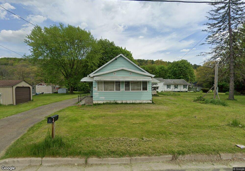
1204 Laurelton Dr Endicott, NY 13760
Estimated Value: $110,000 - $144,210
2
Beds
1
Bath
864
Sq Ft
$150/Sq Ft
Est. Value
About This Home
This home is located at 1204 Laurelton Dr, Endicott, NY 13760 and is currently estimated at $129,303, approximately $149 per square foot. 1204 Laurelton Dr is a home located in Broome County with nearby schools including Union-Endicott High School, All Saints, and All Saints School.
Ownership History
Date
Name
Owned For
Owner Type
Purchase Details
Closed on
Dec 18, 2018
Sold by
Faros Aero Llc
Bought by
Kevin Card Llc
Current Estimated Value
Purchase Details
Closed on
Jul 16, 2015
Sold by
Giles Dale
Bought by
Faros Aero Llc
Purchase Details
Closed on
Nov 1, 2004
Sold by
Giles Victor
Bought by
Giles Dale
Purchase Details
Closed on
Sep 30, 2004
Sold by
Citifinancial Mtg Co Inc
Bought by
Giles Victor
Purchase Details
Closed on
May 14, 2004
Sold by
Fox Nancy
Bought by
Citifinancial Mtg Co Inc
Purchase Details
Closed on
May 7, 1997
Purchase Details
Closed on
Dec 10, 1996
Create a Home Valuation Report for This Property
The Home Valuation Report is an in-depth analysis detailing your home's value as well as a comparison with similar homes in the area
Home Values in the Area
Average Home Value in this Area
Purchase History
| Date | Buyer | Sale Price | Title Company |
|---|---|---|---|
| Kevin Card Llc | $31,000 | None Available | |
| Faros Aero Llc | -- | None Available | |
| Giles Dale | -- | Michael Sherwood | |
| Giles Victor | $35,000 | Michael D Sherwood | |
| Citifinancial Mtg Co Inc | $25,000 | Steven Baum | |
| -- | -- | -- | |
| -- | $129,206 | -- |
Source: Public Records
Tax History Compared to Growth
Tax History
| Year | Tax Paid | Tax Assessment Tax Assessment Total Assessment is a certain percentage of the fair market value that is determined by local assessors to be the total taxable value of land and additions on the property. | Land | Improvement |
|---|---|---|---|---|
| 2024 | $2,855 | $2,900 | $200 | $2,700 |
| 2023 | $3,094 | $2,900 | $200 | $2,700 |
| 2022 | $3,096 | $2,900 | $200 | $2,700 |
| 2021 | $3,028 | $2,900 | $200 | $2,700 |
| 2020 | $2,958 | $2,900 | $200 | $2,700 |
| 2019 | $0 | $2,900 | $200 | $2,700 |
| 2018 | $4,996 | $2,900 | $200 | $2,700 |
| 2017 | $2,757 | $2,900 | $200 | $2,700 |
| 2016 | $2,703 | $2,900 | $200 | $2,700 |
| 2015 | -- | $2,900 | $200 | $2,700 |
| 2014 | -- | $2,900 | $200 | $2,700 |
Source: Public Records
Map
Nearby Homes
- 607 Wallace St
- 915 Harvard St
- 513 Lakeview Dr
- 66 Governeurs Ln
- 804 Glendale Dr
- 614 Barnes Ave
- 73 Governeurs Ln
- 843 Day Hollow Rd
- 419 June St
- 215 Jamaica Blvd
- 91 & 93 Skye Island Dr
- 319 Birdsall St
- 223 Jamaica Blvd
- 304 Birdsall St
- 1219 Crestview Dr
- 503 Zimmer Ave
- 304 Groats St
- 100 Cornell Ave
- 76 Lake Ave
- 107 W Franklin St
- 216 Duke St
- 214 Duke St
- 209 Orman St
- 1209 Laurelton Dr
- 302 Duke St
- 210 Duke St
- 1302 Laurelton Dr
- 1108 Laurelton Dr
- 1113 Laurelton Dr
- 217 Duke St
- 1303 Laurelton Dr
- 1204 Union Center Maine Hwy
- 1209 River Dr
- 211 Duke St
- 1108 Union Center Maine Hwy
- 209 Duke St
- 1102 Laurelton Dr
- 214 Ardmore St
- 212 Ardmore St
- 1311 Laurelton Dr