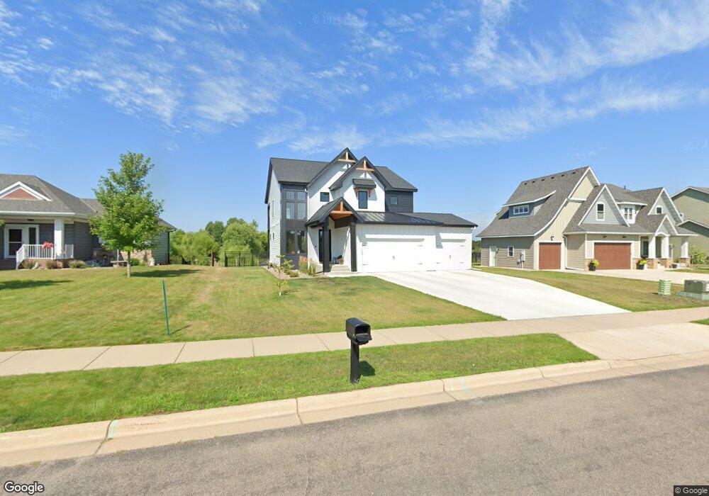
1205 20th Ave S Sartell, MN 56377
Estimated Value: $733,000 - $819,577
5
Beds
4
Baths
3,650
Sq Ft
$214/Sq Ft
Est. Value
About This Home
This home is located at 1205 20th Ave S, Sartell, MN 56377 and is currently estimated at $780,859, approximately $213 per square foot. 1205 20th Ave S is a home located in Stearns County with nearby schools including Oak Ridge Elementary School, Sartell Middle School, and Sartell Senior High School.
Ownership History
Date
Name
Owned For
Owner Type
Purchase Details
Closed on
Aug 19, 2022
Sold by
Werschay Homes Inc
Bought by
Green Justin and Green Lanette
Current Estimated Value
Home Financials for this Owner
Home Financials are based on the most recent Mortgage that was taken out on this home.
Original Mortgage
$839,900
Outstanding Balance
$801,628
Interest Rate
5.3%
Mortgage Type
New Conventional
Estimated Equity
-$20,769
Purchase Details
Closed on
Oct 8, 2020
Sold by
Daybreak Llc
Bought by
Werschay Homes Inc
Purchase Details
Closed on
Mar 1, 2013
Sold by
Rst Land Llc
Bought by
Daybreak Llc
Create a Home Valuation Report for This Property
The Home Valuation Report is an in-depth analysis detailing your home's value as well as a comparison with similar homes in the area
Home Values in the Area
Average Home Value in this Area
Purchase History
| Date | Buyer | Sale Price | Title Company |
|---|---|---|---|
| Green Justin | $849,900 | -- | |
| Werschay Homes Inc | $74,900 | None Available | |
| Daybreak Llc | $335,000 | -- |
Source: Public Records
Mortgage History
| Date | Status | Borrower | Loan Amount |
|---|---|---|---|
| Open | Green Justin | $839,900 |
Source: Public Records
Tax History Compared to Growth
Tax History
| Year | Tax Paid | Tax Assessment Tax Assessment Total Assessment is a certain percentage of the fair market value that is determined by local assessors to be the total taxable value of land and additions on the property. | Land | Improvement |
|---|---|---|---|---|
| 2025 | $10,208 | $684,400 | $77,000 | $607,400 |
| 2024 | $10,208 | $705,600 | $77,000 | $628,600 |
| 2023 | $9,820 | $686,300 | $77,000 | $609,300 |
| 2022 | $1,294 | $70,000 | $70,000 | $0 |
| 2021 | $1,312 | $70,000 | $70,000 | $0 |
| 2020 | $1,454 | $70,000 | $70,000 | $0 |
| 2019 | $1,458 | $70,000 | $70,000 | $0 |
| 2018 | $1,490 | $70,000 | $70,000 | $0 |
| 2017 | $1,182 | $45,000 | $45,000 | $0 |
| 2016 | $800 | $0 | $0 | $0 |
| 2015 | $818 | $0 | $0 | $0 |
| 2014 | -- | $0 | $0 | $0 |
Source: Public Records
Map
Nearby Homes
- 1309 20th Ave S
- XXXX 20th Ave S
- TBD 20th Ave S
- 1089 20th Ave S
- 1504 20th Ave S
- 1509 Killdeer Ave
- 1850 19th Ave S
- 2035 Sandstone Loop N
- 1401 15th St S
- 2011 Sandstone Loop N
- 2000 Sandstone Loop N
- 1911 Whippoorwill Way Unit 7
- 2108 Lindas Ct
- 1108 Mockingbird Loop
- 1916 Sandstone Loop S
- 1928 Sandstone Loop S
- 1137 Mockingbird Loop
- 1113 18th St S
- 1109 18th St S
- 1116 18th St S
- 1201 20th Ave S
- 1113 20th Ave S
- 1200 20th Ave S
- 1300 20th Ave S
- 1204 20th Ave S
- 1304 20th Ave S
- 1109 20th Ave S
- 1109 20th Ave S
- 1400 20th Ave S
- xxx 20th Ave S
- 1105 20th Ave S
- 1401 20th Ave S
- 1404 20th Ave S
- 1405 20th Ave S
- 1408 20th Ave S
- 1409 20th Ave S
- 1909 15th-Street-s
- 1413 20th Ave S
- 1909 15th St S
- 1905 15th St S