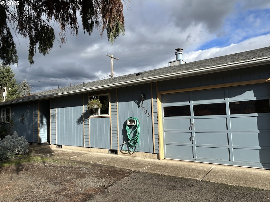
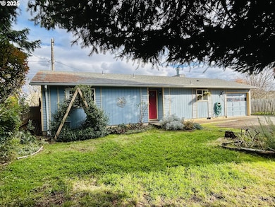
1205 Mill St Springfield, OR 97477
West Springfield NeighborhoodEstimated payment $2,015/month
Highlights
- Private Yard
- Converted Garage
- Window Unit Cooling System
- No HOA
- 1 Car Attached Garage
- Patio
About This Home
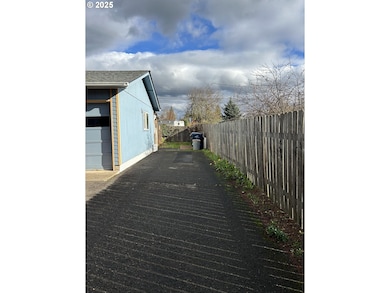
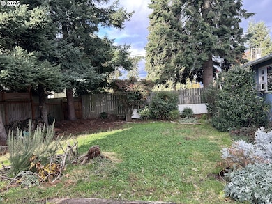
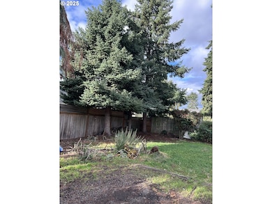
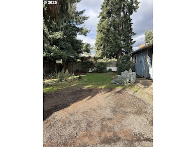
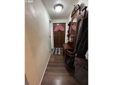
Cozy ranch style home that is recessed from the street. This well cared for home has three bedrooms and one bathroom. From the entry hallway you can enter the living room or kitchen. The eat-in kitchen includes a built-in oven with an electric range, microwave above the range, built-in dishwasher, and freestanding refrigerator. Living room with wood burning fireplace. Jack and Jill style bathroom with entry from the primary bedroom and from the hallway. Bathroom includes a shower over tub and a linen cabinet with a separating door from the rest of the bathroom. Each bedroom comes with window AC units. Updates include vinyl plank flooring throughout, a newer water heater installed this year, and a new roof as of January 2025! Garage is semi-converted with a floating wall and enough room to park a motorcycle and/or bikes as some examples. Washer/dryer hook-ups are located on the other side of the floating wall. This semi-converted space has much potential for various possibilities. Backyard is fully fenced, with many established plants, and a covered patio. Plants include and not limited to: strawberry, raspberry, blueberry, artichoke, onion, jasmine, evergreen clematis, hops, 2 lilac trees, an herb garden and more. It has come to our attention that some navigation systems are giving directions to turn onto 1st Place or 1st Street, please turn onto "Mill Street," the property cannot be accessed from 1st. Thank you. This home is located on a flag lot down a long driveway accessible from Mill St. behind another home. The driveway is across from cross street "K."
Listing Agent
Keller Williams Realty Eugene and Springfield Brokerage Phone: 541-913-7334 License #201213830 Listed on: 11/21/2025

Home Details
Home Type
- Single Family
Est. Annual Taxes
- $2,912
Year Built
- Built in 1978
Lot Details
- 6,969 Sq Ft Lot
- Fenced
- Private Yard
Parking
- 1 Car Attached Garage
- Converted Garage
- On-Street Parking
- Off-Street Parking
Home Design
- Composition Roof
- Lap Siding
- Plywood Siding Panel T1-11
- Concrete Perimeter Foundation
Interior Spaces
- 976 Sq Ft Home
- 1-Story Property
- Wood Burning Fireplace
- Vinyl Clad Windows
- Family Room
- Living Room
- Dining Room
- Crawl Space
Kitchen
- Built-In Oven
- Built-In Range
- Microwave
- Dishwasher
Bedrooms and Bathrooms
- 3 Bedrooms
- 1 Full Bathroom
Outdoor Features
- Patio
Schools
- Two Rivers Elementary School
- Hamlin Middle School
- Springfield High School
Utilities
- Window Unit Cooling System
- Heating unit installed on the ceiling
- Electric Water Heater
Community Details
- No Home Owners Association
Listing and Financial Details
- Assessor Parcel Number 1274487
Map
Home Values in the Area
Average Home Value in this Area
Tax History
| Year | Tax Paid | Tax Assessment Tax Assessment Total Assessment is a certain percentage of the fair market value that is determined by local assessors to be the total taxable value of land and additions on the property. | Land | Improvement |
|---|---|---|---|---|
| 2025 | $2,912 | $158,787 | -- | -- |
| 2024 | $2,865 | $154,163 | -- | -- |
| 2023 | $2,865 | $149,673 | $0 | $0 |
| 2022 | $2,653 | $145,314 | $0 | $0 |
| 2021 | $2,606 | $141,082 | $0 | $0 |
| 2020 | $2,529 | $136,973 | $0 | $0 |
| 2019 | $2,453 | $132,984 | $0 | $0 |
| 2018 | $2,313 | $125,350 | $0 | $0 |
| 2017 | $2,224 | $125,350 | $0 | $0 |
| 2016 | $2,177 | $121,699 | $0 | $0 |
| 2015 | $2,115 | $118,154 | $0 | $0 |
| 2014 | $2,083 | $114,713 | $0 | $0 |
Property History
| Date | Event | Price | List to Sale | Price per Sq Ft |
|---|---|---|---|---|
| 01/23/2026 01/23/26 | Pending | -- | -- | -- |
| 12/12/2025 12/12/25 | Price Changed | $345,000 | -2.8% | $353 / Sq Ft |
| 11/21/2025 11/21/25 | For Sale | $355,000 | -- | $364 / Sq Ft |
Purchase History
| Date | Type | Sale Price | Title Company |
|---|---|---|---|
| Warranty Deed | $150,000 | Western Title | |
| Interfamily Deed Transfer | -- | Evergreen Land Title Co | |
| Warranty Deed | $94,200 | Western Pioneer Title Co |
Mortgage History
| Date | Status | Loan Amount | Loan Type |
|---|---|---|---|
| Open | $140,415 | FHA |
Source: Regional Multiple Listing Service (RMLS)
MLS Number: 549924319
APN: 1274487
Disclaimer: Certain information contained herein is derived from information provided by parties other than Homes.com. All information provided is deemed reliable, but is not guaranteed to be accurate and should be independently verified.
![]() The content relating to real estate for sale on this web site comes in part from the IDX program of the RMLS™ of Portland, Oregon. Real estate listings held by brokerage firms other than Ten-X are marked with the RMLS™ logo, and detailed information about these properties includes the names of the listing brokers. Listing content is copyright © 2026 RMLS™, Portland, Oregon. Some properties which appear for sale on this web site may subsequently have sold or may no longer be available. All information provided is deemed reliable but is not guaranteed and should be independently verified.
The content relating to real estate for sale on this web site comes in part from the IDX program of the RMLS™ of Portland, Oregon. Real estate listings held by brokerage firms other than Ten-X are marked with the RMLS™ logo, and detailed information about these properties includes the names of the listing brokers. Listing content is copyright © 2026 RMLS™, Portland, Oregon. Some properties which appear for sale on this web site may subsequently have sold or may no longer be available. All information provided is deemed reliable but is not guaranteed and should be independently verified.
Ask me questions while you tour the home.