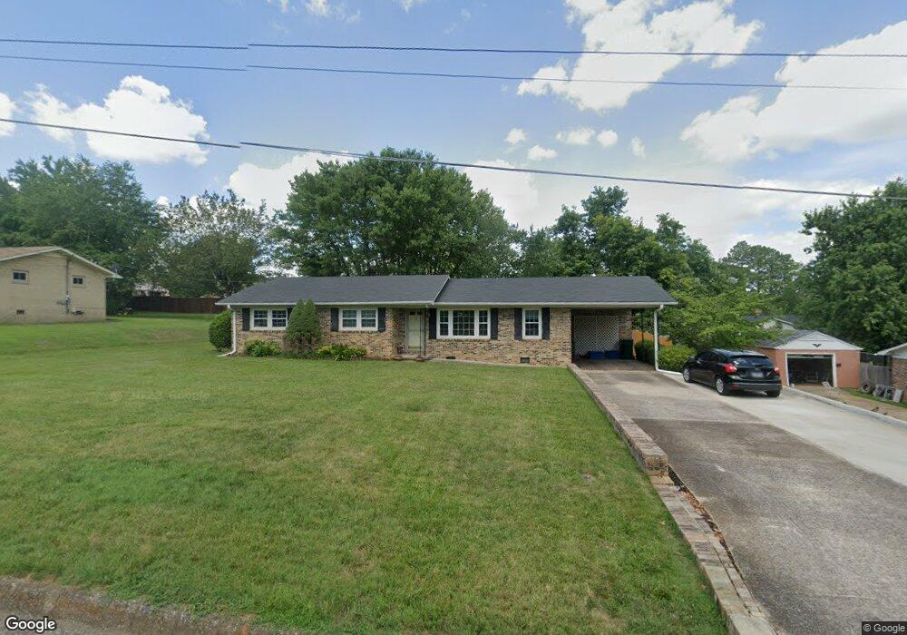
1205 Stewart Dr Pulaski, TN 38478
Estimated Value: $215,983 - $281,000
3
Beds
2
Baths
1,520
Sq Ft
$167/Sq Ft
Est. Value
About This Home
This home is located at 1205 Stewart Dr, Pulaski, TN 38478 and is currently estimated at $254,496, approximately $167 per square foot. 1205 Stewart Dr is a home located in Giles County with nearby schools including Pulaski Elementary School, Southside Elementary School, and Bridgeforth Middle School.
Ownership History
Date
Name
Owned For
Owner Type
Purchase Details
Closed on
Jun 26, 2017
Sold by
Cardin Bethe
Bought by
Visser Greg R
Current Estimated Value
Home Financials for this Owner
Home Financials are based on the most recent Mortgage that was taken out on this home.
Original Mortgage
$109,479
Outstanding Balance
$89,737
Interest Rate
3.5%
Mortgage Type
FHA
Estimated Equity
$164,759
Purchase Details
Closed on
Mar 23, 2017
Sold by
Parsons Margaret A
Bought by
Cardin Bethe
Purchase Details
Closed on
Nov 16, 1992
Bought by
Shelby Margaret A
Purchase Details
Closed on
Mar 21, 1988
Bought by
Beadle James C and Beadle Tracy
Purchase Details
Closed on
Jul 19, 1973
Bought by
Kelley Fred F and Kelley Phyllis
Create a Home Valuation Report for This Property
The Home Valuation Report is an in-depth analysis detailing your home's value as well as a comparison with similar homes in the area
Home Values in the Area
Average Home Value in this Area
Purchase History
| Date | Buyer | Sale Price | Title Company |
|---|---|---|---|
| Visser Greg R | $111,500 | Title And Escrow Llc | |
| Cardin Bethe | $85,000 | -- | |
| Shelby Margaret A | $64,500 | -- | |
| Beadle James C | $42,000 | -- | |
| Kelley Fred F | -- | -- |
Source: Public Records
Mortgage History
| Date | Status | Borrower | Loan Amount |
|---|---|---|---|
| Open | Visser Greg R | $109,479 |
Source: Public Records
Tax History
| Year | Tax Paid | Tax Assessment Tax Assessment Total Assessment is a certain percentage of the fair market value that is determined by local assessors to be the total taxable value of land and additions on the property. | Land | Improvement |
|---|---|---|---|---|
| 2025 | $1,246 | $45,675 | $8,400 | $37,275 |
| 2024 | $1,100 | $45,675 | $8,400 | $37,275 |
| 2023 | $1,100 | $45,675 | $8,400 | $37,275 |
| 2022 | $1,100 | $45,675 | $8,400 | $37,275 |
| 2021 | $802 | $23,675 | $4,100 | $19,575 |
| 2020 | $802 | $23,675 | $4,100 | $19,575 |
| 2019 | $669 | $23,675 | $4,100 | $19,575 |
| 2018 | $802 | $23,675 | $4,100 | $19,575 |
| 2017 | $802 | $23,675 | $4,100 | $19,575 |
| 2016 | $807 | $22,775 | $2,750 | $20,025 |
| 2015 | $761 | $22,775 | $2,750 | $20,025 |
| 2014 | $761 | $22,765 | $0 | $0 |
Source: Public Records
Map
Nearby Homes
- 1205 Beverly Dr
- 1307 Carroll Dr
- 0 Jackson Dr Unit RTC3067618
- 101 Mimi Cir
- 109 Mimi Cir
- 1011 Vales Mill Rd
- 819 Murrey Dr
- 804 Morgan St
- 1336 Charlotte Ct
- 730 Rackley Dr
- 1 Chicken Creek Rd
- 102 Sunset Dr
- 313 W Poplar St
- 602 S 1st St
- 602 Spofford St
- 120 Sunset Dr
- 311 S 1st St
- 857 Hicks Cut Rd
- 226 Rose St
- 318 W Jefferson St
- 1207 Stewart Dr
- 1203 Stewart Dr
- 1204 Parker Dr
- 1206 Parker Dr
- 1206 Stewart Dr
- 1201 Stewart Dr
- 1209 Stewart Dr
- 1204 Stewart Dr
- 1208 Parker Dr
- 1200 Parker Dr
- 1208 Stewart Dr
- 1200 Stewart Dr
- 1211 Stewart Dr
- 1210 Parker Dr
- 1201 Parker Dr
- 1242 Mill St
- 1008 Brindley Dr
- 1209 Parker Dr
- 1012 Brindley Dr
- 1006 Brindley Dr
Your Personal Tour Guide
Ask me questions while you tour the home.