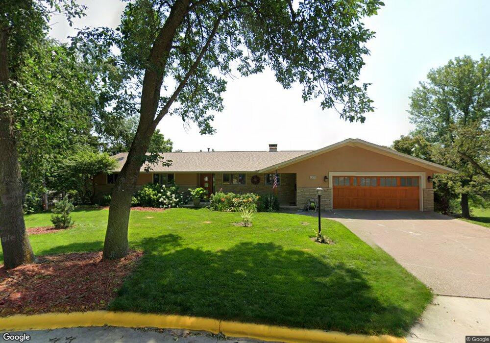
1205 W 6th St Red Wing, MN 55066
Estimated Value: $432,000 - $503,000
5
Beds
3
Baths
3,588
Sq Ft
$129/Sq Ft
Est. Value
About This Home
This home is located at 1205 W 6th St, Red Wing, MN 55066 and is currently estimated at $462,817, approximately $128 per square foot. 1205 W 6th St is a home located in Goodhue County with nearby schools including Sunnyside Elementary School, Burnside Elementary School, and Twin Bluff Middle School.
Ownership History
Date
Name
Owned For
Owner Type
Purchase Details
Closed on
Apr 22, 2016
Sold by
Anderson Howard Elmer and Anderson Dawn Elizabeth
Bought by
Brennan Dennis E and Bundy Daniel R
Current Estimated Value
Purchase Details
Closed on
Jul 26, 2004
Sold by
Unavailable
Bought by
Anderson Howard E and Anderson Dawn E
Create a Home Valuation Report for This Property
The Home Valuation Report is an in-depth analysis detailing your home's value as well as a comparison with similar homes in the area
Home Values in the Area
Average Home Value in this Area
Purchase History
| Date | Buyer | Sale Price | Title Company |
|---|---|---|---|
| Brennan Dennis E | $284,000 | Stewart Title | |
| Anderson Howard E | $270,000 | -- |
Source: Public Records
Tax History Compared to Growth
Tax History
| Year | Tax Paid | Tax Assessment Tax Assessment Total Assessment is a certain percentage of the fair market value that is determined by local assessors to be the total taxable value of land and additions on the property. | Land | Improvement |
|---|---|---|---|---|
| 2025 | $5,656 | $429,800 | $137,200 | $292,600 |
| 2024 | -- | $424,700 | $137,200 | $287,500 |
| 2023 | $5,408 | $404,700 | $137,000 | $267,700 |
| 2022 | $5,210 | $399,900 | $134,300 | $265,600 |
| 2021 | $4,912 | $353,000 | $134,300 | $218,700 |
| 2020 | $4,956 | $338,400 | $134,300 | $204,100 |
| 2019 | $4,996 | $320,000 | $134,300 | $185,700 |
| 2018 | $4,222 | $325,800 | $134,300 | $191,500 |
| 2017 | $4,130 | $295,300 | $134,300 | $161,000 |
| 2016 | $4,434 | $292,600 | $134,300 | $158,300 |
| 2015 | $4,366 | $286,400 | $134,300 | $152,100 |
| 2014 | -- | $278,000 | $134,300 | $143,700 |
Source: Public Records
Map
Nearby Homes
- 1130 W 4th St
- 1062 Putnam Ave
- 1578 Alvina St
- 1029 Putnam Ave
- 1108 Hawthorne St
- 1012 West Ave
- 815 W 4th St
- 504 Buchanan St Unit 506
- 1715 W 5th St
- 802 West Ave
- 1224 Tee Up Ln
- 1738 W 6th St
- 717 Blaine St
- 642 Grace St
- 1238 Foursome St
- 716 Central Ave
- 1218 Central Ave
- 924 Central Ave
- 1606 Reichert Ave
- 523 East Ave Unit 211
- 1180 College Ave
- 1211 W 6th St
- 1178 College Ave
- 526 Williams St
- 1221 W 6th St
- 525 Williams St
- 526 Williams Ave
- 519 Williams St
- 518 Williams Ave
- 518 Williams St
- 1233 W 6th St
- 1176 College Ave
- 1172 College Ave
- 1226 W 6th St
- 1170 College Ave
- 1174 College Ave
- 512 Williams St
- 512 Williams St
- 506 Williams Ave
- 506 Williams Ave