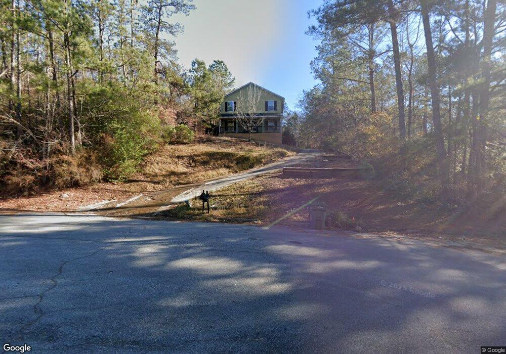
1206 Kings Mountain Ct Columbus, GA 31907
Eastern Columbus NeighborhoodEstimated Value: $206,000 - $298,000
--
Bed
3
Baths
2,580
Sq Ft
$101/Sq Ft
Est. Value
About This Home
This home is located at 1206 Kings Mountain Ct, Columbus, GA 31907 and is currently estimated at $259,544, approximately $100 per square foot. 1206 Kings Mountain Ct is a home located in Muscogee County with nearby schools including Dawson Elementary School, East Columbus Magnet Academy, and Spencer High School.
Ownership History
Date
Name
Owned For
Owner Type
Purchase Details
Closed on
Jan 28, 2005
Sold by
Colonial Bank Na
Bought by
Haghighat Nia Farid and Haghighat Nia Katren
Current Estimated Value
Create a Home Valuation Report for This Property
The Home Valuation Report is an in-depth analysis detailing your home's value as well as a comparison with similar homes in the area
Home Values in the Area
Average Home Value in this Area
Purchase History
| Date | Buyer | Sale Price | Title Company |
|---|---|---|---|
| Haghighat Nia Farid | -- | None Available |
Source: Public Records
Tax History Compared to Growth
Tax History
| Year | Tax Paid | Tax Assessment Tax Assessment Total Assessment is a certain percentage of the fair market value that is determined by local assessors to be the total taxable value of land and additions on the property. | Land | Improvement |
|---|---|---|---|---|
| 2025 | $3,007 | $76,824 | $12,660 | $64,164 |
| 2024 | $8,384 | $97,348 | $12,660 | $84,688 |
| 2023 | $3,835 | $97,348 | $12,660 | $84,688 |
| 2022 | $2,877 | $70,456 | $12,660 | $57,796 |
| 2021 | $2,916 | $63,476 | $12,660 | $50,816 |
| 2020 | $2,592 | $63,476 | $12,660 | $50,816 |
| 2019 | $2,601 | $63,476 | $12,660 | $50,816 |
| 2018 | $2,601 | $63,476 | $12,660 | $50,816 |
| 2017 | $5,847 | $63,476 | $12,660 | $50,816 |
| 2016 | $2,879 | $69,800 | $1,480 | $68,320 |
| 2015 | $1,153 | $69,800 | $1,480 | $68,320 |
| 2014 | $2,886 | $69,800 | $1,480 | $68,320 |
| 2013 | -- | $69,800 | $1,480 | $68,320 |
Source: Public Records
Map
Nearby Homes
- 1513 Alamo Dr
- 5310 Stoney Point Rd
- 4462 Walking Stick Way
- 5336 Gettysburg Way
- 1238 Brandywine Dr
- 5664 St Marys Rd
- 1210 Bunker Hill Rd
- 5613 Quebec Dr
- 5219 Argonne Dr
- 5644 Quebec Dr
- 4408 Walking Stick Way
- 1340 Bunker Ridge Ln
- 5728 Lexington Dr
- 849 Bunker Hill Rd
- 5109 Lexington Ln
- 5116 Magazine Ln
- 5090 Lexington Ln
- 780 Honey Do Ct
- 4939 Aaron Dr
- 1025 Belmar St
- 1214 Kings Mountain Ct
- 1216 Kings Mountain Ct Unit A
- 1201 Kings Mountain Ct
- 0 Kings Mountain Ct
- 1224 Kings Mountain Ct
- 1213 Kings Mountain Ct
- 1207 Kings Mountain Ct
- 1203 Kings Mountain Ct
- 1230 Kings Mountain Ct
- 1223 Kings Mountain Ct
- 1229 Kings Mountain Ct
- 1238 Kings Mountain Ct
- 5433 Gettysburg Way
- 5441 Gettysburg Way
- 5427 Gettysburg Way
- 5447 Gettysburg Way
- 5421 Gettysburg Way
- 1235 Kings Mountain Ct Unit A
- 5413 Gettysburg Way
- 3010 Alamo Ct Unit D