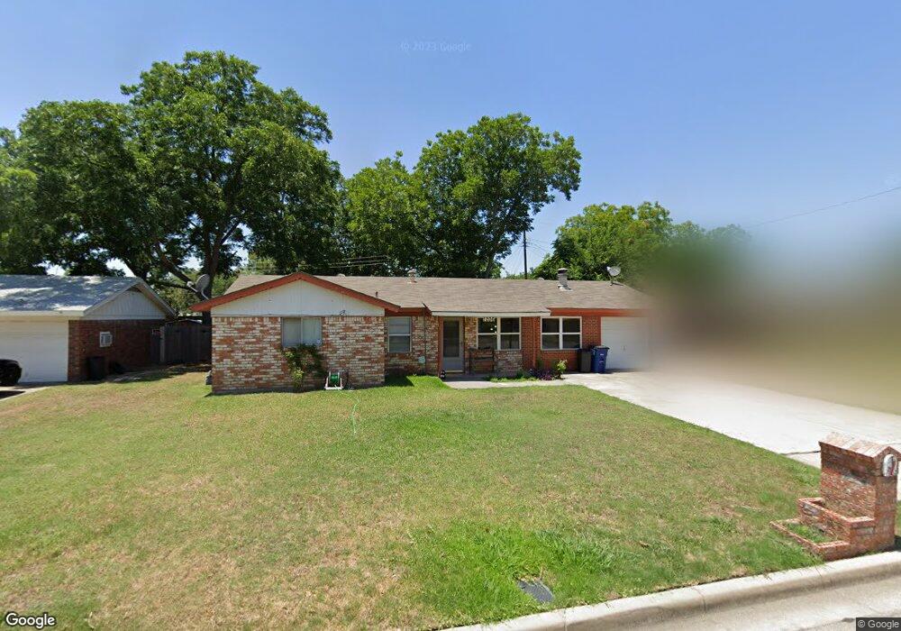
1206 Paula Ln Euless, TX 76040
Estimated Value: $281,056 - $313,000
3
Beds
2
Baths
1,442
Sq Ft
$208/Sq Ft
Est. Value
About This Home
This home is located at 1206 Paula Ln, Euless, TX 76040 and is currently estimated at $299,764, approximately $207 per square foot. 1206 Paula Ln is a home located in Tarrant County with nearby schools including Bell Manor Elementary School, Central J High School, and Trinity High School.
Ownership History
Date
Name
Owned For
Owner Type
Purchase Details
Closed on
Sep 5, 2002
Sold by
Tucker Cheryl D
Bought by
Chadwick Monica A
Current Estimated Value
Home Financials for this Owner
Home Financials are based on the most recent Mortgage that was taken out on this home.
Original Mortgage
$72,000
Outstanding Balance
$30,450
Interest Rate
6.41%
Estimated Equity
$269,314
Purchase Details
Closed on
Aug 22, 2002
Sold by
Parish Robert Wayne
Bought by
Parish Cheryl Dea and Tucker Cheryl Dea
Home Financials for this Owner
Home Financials are based on the most recent Mortgage that was taken out on this home.
Original Mortgage
$72,000
Outstanding Balance
$30,450
Interest Rate
6.41%
Estimated Equity
$269,314
Purchase Details
Closed on
Aug 2, 1999
Sold by
Hatley Jerry L and Hatley Sandra L
Bought by
Tucker Cheryl D
Home Financials for this Owner
Home Financials are based on the most recent Mortgage that was taken out on this home.
Original Mortgage
$35,100
Interest Rate
7.63%
Create a Home Valuation Report for This Property
The Home Valuation Report is an in-depth analysis detailing your home's value as well as a comparison with similar homes in the area
Home Values in the Area
Average Home Value in this Area
Purchase History
| Date | Buyer | Sale Price | Title Company |
|---|---|---|---|
| Chadwick Monica A | -- | Commonwealth Land Title | |
| Parish Cheryl Dea | -- | -- | |
| Tucker Cheryl D | -- | Safeco Land Title |
Source: Public Records
Mortgage History
| Date | Status | Borrower | Loan Amount |
|---|---|---|---|
| Open | Chadwick Monica A | $72,000 | |
| Previous Owner | Tucker Cheryl D | $35,100 |
Source: Public Records
Tax History
| Year | Tax Paid | Tax Assessment Tax Assessment Total Assessment is a certain percentage of the fair market value that is determined by local assessors to be the total taxable value of land and additions on the property. | Land | Improvement |
|---|---|---|---|---|
| 2025 | $1,311 | $295,997 | $50,000 | $245,997 |
| 2024 | $1,311 | $295,997 | $50,000 | $245,997 |
| 2023 | $4,025 | $253,348 | $35,000 | $218,348 |
| 2022 | $4,182 | $218,547 | $35,000 | $183,547 |
| 2021 | $3,980 | $197,073 | $35,000 | $162,073 |
| 2020 | $3,654 | $160,872 | $35,000 | $125,872 |
| 2019 | $3,513 | $162,059 | $35,000 | $127,059 |
| 2018 | $2,015 | $137,046 | $18,000 | $119,046 |
| 2017 | $3,119 | $129,692 | $18,000 | $111,692 |
| 2016 | $3,028 | $125,883 | $18,000 | $107,883 |
| 2015 | $2,042 | $82,200 | $18,000 | $64,200 |
| 2014 | $2,042 | $82,200 | $18,000 | $64,200 |
Source: Public Records
Map
Nearby Homes
- 1206 Hanover Dr
- 1216 Princeton Place
- 808 Gregory Ave
- 1115 Middlebury Ln
- 804 Natchez Ave
- 1000 Sherwood Dr
- 2620 Britany Cir
- 933 Charleston Ct
- 1613 Trinity Ct
- 3532 Frazier Ct
- 1124 Sherwood Dr
- 1116 Highpoint Rd
- 2428 Chestnut Way
- 1720 Winchester Way
- 1405 Bryan Dr
- 904 Dee Ln
- 904 Nelson Terrace
- 3604 Twin Pond Trail
- 1417 Autumn Chase Square
- 10905 Rippling Brook Way Unit 114