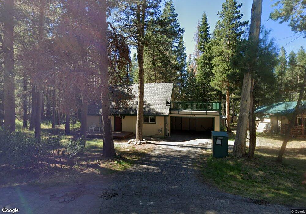
1207 Sioux St South Lake Tahoe, CA 96150
Estimated Value: $540,000 - $675,000
3
Beds
2
Baths
1,472
Sq Ft
$419/Sq Ft
Est. Value
About This Home
This home is located at 1207 Sioux St, South Lake Tahoe, CA 96150 and is currently estimated at $616,543, approximately $418 per square foot. 1207 Sioux St is a home located in El Dorado County with nearby schools including Tahoe Valley Elementary School, South Tahoe Middle School, and South Tahoe High School.
Ownership History
Date
Name
Owned For
Owner Type
Purchase Details
Closed on
Jan 17, 2018
Sold by
Taylor Stephen and Turner Ruth
Bought by
Taylor Stephen R and Turner Ruth J
Current Estimated Value
Purchase Details
Closed on
Dec 10, 2008
Sold by
Taylor Henry W and Taylor Anna
Bought by
Taylor Henry W and Taylor Anna J
Purchase Details
Closed on
Jan 15, 2002
Sold by
Mcalister Judy A
Bought by
Taylor Henry W and Taylor Anna
Create a Home Valuation Report for This Property
The Home Valuation Report is an in-depth analysis detailing your home's value as well as a comparison with similar homes in the area
Home Values in the Area
Average Home Value in this Area
Purchase History
| Date | Buyer | Sale Price | Title Company |
|---|---|---|---|
| Taylor Stephen R | -- | None Available | |
| Taylor Henry W | -- | None Available | |
| Taylor Henry W | $236,000 | First American Title Ins Co |
Source: Public Records
Tax History Compared to Growth
Tax History
| Year | Tax Paid | Tax Assessment Tax Assessment Total Assessment is a certain percentage of the fair market value that is determined by local assessors to be the total taxable value of land and additions on the property. | Land | Improvement |
|---|---|---|---|---|
| 2025 | $3,739 | $348,609 | $103,396 | $245,213 |
| 2024 | $3,739 | $341,774 | $101,369 | $240,405 |
| 2023 | $3,675 | $335,074 | $99,382 | $235,692 |
| 2022 | $3,692 | $333,505 | $97,434 | $236,071 |
| 2021 | $3,580 | $324,515 | $95,524 | $228,991 |
| 2020 | $3,585 | $323,764 | $94,545 | $229,219 |
| 2019 | $3,569 | $317,515 | $92,692 | $224,823 |
| 2018 | $3,492 | $311,388 | $90,875 | $220,513 |
| 2017 | $3,439 | $305,382 | $89,094 | $216,288 |
| 2016 | $3,371 | $299,494 | $87,348 | $212,146 |
| 2015 | $3,150 | $295,073 | $86,037 | $209,036 |
| 2014 | $3,150 | $284,393 | $84,352 | $200,041 |
Source: Public Records
Map
Nearby Homes
- 1140 Sioux St
- 1666 Arapahoe St
- 1982 Cherokee St
- 2001 Washoe St
- 2877 Us Highway 50
- 1675 Arapahoe St
- 1940 Apache Ave
- 1935 Apache Ave
- 1431 Vanderhoof Rd
- 1442 Vanderhoof Rd
- 1444 Apache Ave
- 1513 Cree St
- 1876 Bella Coola Dr
- 1580 Boca Raton Dr
- 2181 Pinewood Dr
- 2182 Lindenwood Dr
- 1671 Crystal Air Dr
- 1871 Normuk St
- 2189 Cornelian Dr
- 1593 Plumas Cir
- 1211 Sioux St
- 1198 E San Bernardino Ave
- 1195 Sioux St
- 1164 San Diego St
- 1189 Sioux St
- 1712 Arrowhead Ave
- 1184 E San Bernardino Ave
- 1185 Sioux St
- 1186 Sioux St
- 1186 Sioux St
- 1212 E San Bernardino Ave
- 1197 Tomahawk Ln
- 1721 Arrowhead Ave
- 1193 Tomahawk Ln
- 1715 Arrowhead Ave
- 1725 Arrowhead Ave
- 1180 Sioux St
- 1213 E San Bernardino Ave
- 1729 Arrowhead Ave
- 1187 Tomahawk Ln