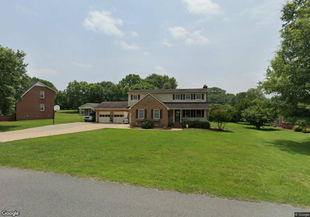
1207 Suzanne St Kings Mountain, NC 28086
Estimated Value: $346,818 - $404,000
3
Beds
2
Baths
2,364
Sq Ft
$162/Sq Ft
Est. Value
About This Home
This home is located at 1207 Suzanne St, Kings Mountain, NC 28086 and is currently estimated at $381,955, approximately $161 per square foot. 1207 Suzanne St is a home located in Cleveland County with nearby schools including North Elementary School, Kings Mountain Intermediate School, and Kings Mountain Middle.
Ownership History
Date
Name
Owned For
Owner Type
Purchase Details
Closed on
Jun 2, 2009
Sold by
Jackson Sherrill Eugene and Jackson Pamela B
Bought by
Laney Jason D and Laney Joy S
Current Estimated Value
Home Financials for this Owner
Home Financials are based on the most recent Mortgage that was taken out on this home.
Original Mortgage
$148,002
Outstanding Balance
$93,711
Interest Rate
4.81%
Mortgage Type
Purchase Money Mortgage
Estimated Equity
$288,244
Create a Home Valuation Report for This Property
The Home Valuation Report is an in-depth analysis detailing your home's value as well as a comparison with similar homes in the area
Home Values in the Area
Average Home Value in this Area
Purchase History
| Date | Buyer | Sale Price | Title Company |
|---|---|---|---|
| Laney Jason D | $146,000 | None Available |
Source: Public Records
Mortgage History
| Date | Status | Borrower | Loan Amount |
|---|---|---|---|
| Open | Laney Jason D | $148,002 |
Source: Public Records
Tax History Compared to Growth
Tax History
| Year | Tax Paid | Tax Assessment Tax Assessment Total Assessment is a certain percentage of the fair market value that is determined by local assessors to be the total taxable value of land and additions on the property. | Land | Improvement |
|---|---|---|---|---|
| 2025 | $2,617 | $255,268 | $41,979 | $213,289 |
| 2024 | $1,807 | $152,628 | $29,985 | $122,643 |
| 2023 | $1,798 | $152,628 | $29,985 | $122,643 |
| 2022 | $1,722 | $152,628 | $29,985 | $122,643 |
| 2021 | $1,731 | $152,628 | $29,985 | $122,643 |
| 2020 | $1,453 | $124,412 | $19,789 | $104,623 |
| 2019 | $1,453 | $124,412 | $19,789 | $104,623 |
| 2018 | $1,452 | $124,412 | $19,789 | $104,623 |
| 2017 | $1,444 | $124,412 | $19,789 | $104,623 |
| 2016 | $1,449 | $124,412 | $19,789 | $104,623 |
| 2015 | $1,645 | $145,197 | $19,189 | $126,008 |
| 2014 | $1,645 | $145,197 | $19,189 | $126,008 |
Source: Public Records
Map
Nearby Homes
- 208 Victoria Cir
- 117 Parker Claire Ln
- 111 Parker Claire Ln
- 213 Parker Claire Ln
- 1301 Shelby Rd
- 442 Phifer Rd
- 1417 Merrimont Ave
- 417 Phifer Rd
- 1500 Shelby Rd
- 521 Coman Ln
- 811 W Gold St Unit 26
- 430 Fulton Dr
- 1610 Shelby Rd
- 1427 Merrimont Ave
- 155 Patterson Rd
- 804 Lee St
- 104 Edison St
- Plan 2338 at Cottages at Clovis Point
- Plan 2723 at Cottages at Clovis Point
- Plan 2539 at Cottages at Clovis Point
- 1205 Suzanne St
- 1209 Suzanne St
- 1203 Suzanne St
- 300 Garrison Dr
- 112 Independence Ct
- 110 Independence Ct
- 201 N Roxford Rd
- 106 Garrison Dr
- 106 Garrison Dr
- 108 Independence Ct
- 205 N Roxford Rd
- 299 Garrison Dr
- 111 N Roxford Rd
- 301 Garrison Dr
- 113 Independence Ct
- 109 N Roxford Rd
- 111 Independence Ct
- 102 Garrison Dr
- 109 Independence Ct
- 107 Independence Ct