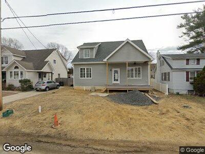
1208 Sherman Ave Point Pleasant Boro, NJ 08742
Estimated Value: $747,492 - $951,000
2
Beds
1
Bath
880
Sq Ft
$915/Sq Ft
Est. Value
About This Home
This home is located at 1208 Sherman Ave, Point Pleasant Boro, NJ 08742 and is currently estimated at $804,873, approximately $914 per square foot. 1208 Sherman Ave is a home located in Ocean County with nearby schools including Point Pleasant High School and St. Peter School.
Ownership History
Date
Name
Owned For
Owner Type
Purchase Details
Closed on
Dec 5, 2011
Sold by
Corbin Jill and Ocone Jill
Bought by
Ocone Anthony G and Ocone Jill
Current Estimated Value
Home Financials for this Owner
Home Financials are based on the most recent Mortgage that was taken out on this home.
Original Mortgage
$100,000
Outstanding Balance
$71,001
Interest Rate
3.98%
Mortgage Type
New Conventional
Purchase Details
Closed on
Dec 22, 1998
Sold by
Corbin Glenn M and Corbin James H
Bought by
Corbin Jill
Home Financials for this Owner
Home Financials are based on the most recent Mortgage that was taken out on this home.
Original Mortgage
$68,000
Interest Rate
6.67%
Create a Home Valuation Report for This Property
The Home Valuation Report is an in-depth analysis detailing your home's value as well as a comparison with similar homes in the area
Home Values in the Area
Average Home Value in this Area
Purchase History
| Date | Buyer | Sale Price | Title Company |
|---|---|---|---|
| Ocone Anthony G | -- | None Available | |
| Corbin Jill | $80,000 | -- |
Source: Public Records
Mortgage History
| Date | Status | Borrower | Loan Amount |
|---|---|---|---|
| Open | Ocone Anthony G | $100,000 | |
| Closed | Corbin Jill | $68,000 |
Source: Public Records
Tax History Compared to Growth
Tax History
| Year | Tax Paid | Tax Assessment Tax Assessment Total Assessment is a certain percentage of the fair market value that is determined by local assessors to be the total taxable value of land and additions on the property. | Land | Improvement |
|---|---|---|---|---|
| 2024 | $10,705 | $489,700 | $186,000 | $303,700 |
| 2023 | $3,982 | $186,000 | $186,000 | $0 |
| 2022 | $3,982 | $186,000 | $186,000 | $0 |
| 2021 | $3,921 | $186,000 | $186,000 | $0 |
| 2020 | $3,880 | $186,000 | $186,000 | $0 |
| 2019 | $4,565 | $221,800 | $186,000 | $35,800 |
| 2018 | $4,429 | $221,800 | $186,000 | $35,800 |
| 2017 | $4,332 | $221,800 | $186,000 | $35,800 |
| 2016 | $4,298 | $221,800 | $186,000 | $35,800 |
| 2015 | $4,247 | $221,800 | $186,000 | $35,800 |
| 2014 | $4,150 | $221,800 | $186,000 | $35,800 |
Source: Public Records
Map
Nearby Homes
- 1409 Buckner St
- 1320 Charles St
- 1030 Ocean Rd
- 1215 Johnson Ave
- 1416 George St
- 1125 Arnold Ave Unit 2
- 22 Cedar Dr
- 284 Osborne Ave
- 827 Rosewood Ave
- 1320 Bay Ave
- 916 Arnold Ave
- 1501 Hulse Rd Unit 18
- 820 Trenton Ave
- 815 Sinclair Rd
- 1117 Bradford Dr
- 842 Arnold Ave Unit 2
- 842 Arnold Ave Unit 1
- 842 Arnold Ave Unit 5
- 842 Arnold Ave Unit 3
- 622 Trenton Ave Unit 311
- 1208 Sherman Ave
- 1206 Sherman Ave
- 1210 Sherman Ave
- 1207 Fleming Ave
- 1214 Sherman Ave
- 1211 Fleming Ave
- 1207 Sherman Ave
- 906 Route 88
- 1202 Sherman Ave
- 904 Route 88
- 1211 Sherman Ave
- 1215 Fleming Ave
- 1216 Sherman Ave
- 902 Route 88
- 904 Ocean Rd
- 912 Route 88
- 900 Route 88
- 1208A Rue Ave
- 1218 Sherman Ave
- 1217 Fleming Ave Unit 19