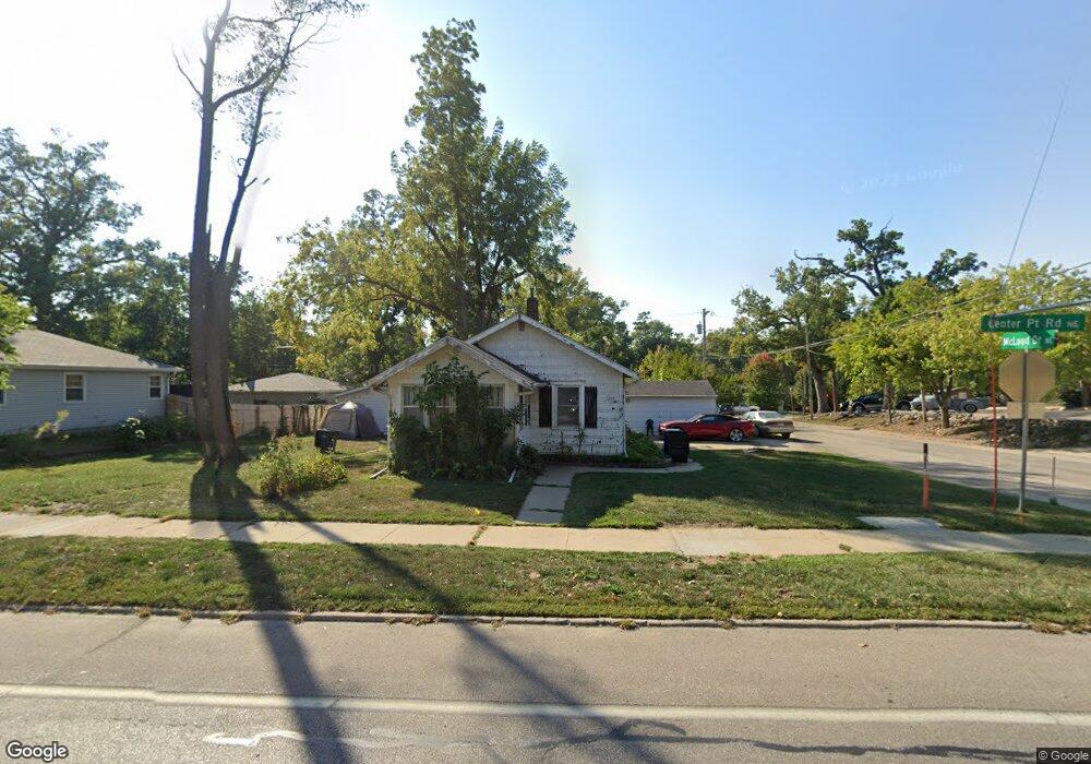
1209 Center Point Rd NE Cedar Rapids, IA 52402
Mound View NeighborhoodEstimated Value: $117,000 - $142,000
2
Beds
2
Baths
792
Sq Ft
$162/Sq Ft
Est. Value
About This Home
This home is located at 1209 Center Point Rd NE, Cedar Rapids, IA 52402 and is currently estimated at $128,343, approximately $162 per square foot. 1209 Center Point Rd NE is a home located in Linn County with nearby schools including Franklin Middle School, George Washington High School, and Isaac Newton Christian Academy.
Ownership History
Date
Name
Owned For
Owner Type
Purchase Details
Closed on
May 24, 2007
Sold by
Price Angela J
Bought by
Perry James P
Current Estimated Value
Home Financials for this Owner
Home Financials are based on the most recent Mortgage that was taken out on this home.
Original Mortgage
$74,164
Outstanding Balance
$45,210
Interest Rate
6.21%
Mortgage Type
Purchase Money Mortgage
Estimated Equity
$83,133
Purchase Details
Closed on
Jul 19, 2001
Sold by
Palmer Robert Paul
Bought by
Price Angela J
Home Financials for this Owner
Home Financials are based on the most recent Mortgage that was taken out on this home.
Original Mortgage
$62,505
Interest Rate
7.22%
Mortgage Type
FHA
Purchase Details
Closed on
Jun 15, 1999
Sold by
Reed Linda Kay
Bought by
Palmer Robert Paul
Create a Home Valuation Report for This Property
The Home Valuation Report is an in-depth analysis detailing your home's value as well as a comparison with similar homes in the area
Home Values in the Area
Average Home Value in this Area
Purchase History
| Date | Buyer | Sale Price | Title Company |
|---|---|---|---|
| Perry James P | $74,500 | None Available | |
| Price Angela J | $62,500 | -- | |
| Palmer Robert Paul | $500 | -- |
Source: Public Records
Mortgage History
| Date | Status | Borrower | Loan Amount |
|---|---|---|---|
| Open | Perry James P | $74,164 | |
| Previous Owner | Price Angela J | $62,505 |
Source: Public Records
Tax History Compared to Growth
Tax History
| Year | Tax Paid | Tax Assessment Tax Assessment Total Assessment is a certain percentage of the fair market value that is determined by local assessors to be the total taxable value of land and additions on the property. | Land | Improvement |
|---|---|---|---|---|
| 2025 | $1,404 | $102,600 | $23,000 | $79,600 |
| 2024 | $1,546 | $96,800 | $20,700 | $76,100 |
| 2023 | $1,546 | $96,800 | $20,700 | $76,100 |
| 2022 | $1,344 | $82,200 | $19,500 | $62,700 |
| 2021 | $1,454 | $73,800 | $16,100 | $57,700 |
| 2020 | $1,454 | $74,500 | $16,100 | $58,400 |
| 2019 | $1,382 | $72,600 | $16,100 | $56,500 |
| 2018 | $1,338 | $72,600 | $16,100 | $56,500 |
| 2017 | $1,403 | $63,800 | $16,100 | $47,700 |
| 2016 | $1,403 | $66,000 | $16,100 | $49,900 |
| 2015 | $1,441 | $67,682 | $16,091 | $51,591 |
| 2014 | $1,256 | $71,199 | $16,091 | $55,108 |
| 2013 | $1,296 | $71,199 | $16,091 | $55,108 |
Source: Public Records
Map
Nearby Homes
- 1046 12th St NE
- 2000 Sierra Cir NE
- 2006 Sierra Cir NE
- 2011 Sierra Cir NE
- 2012 Sierra Cir NE
- 2015 Sierra Cir NE
- 2018 Sierra Cir NE
- 2019 Sierra Cir NE
- 2102 Sierra Cir NE
- 2023 Sierra Cir NE
- 2110 Sierra Cir NE
- 2103 Sierra Cir NE
- 1522 J Ave NE
- 2116 Sierra Cir NE
- 2109 Sierra Cir NE
- 2122 Sierra Cir NE
- 909 Daniels St NE
- 2115 Sierra Cir NE
- 2121 Sierra Cir NE
- 2202 Sierra Cir NE
- 1203 Center Point Rd NE
- 1201 Center Point Rd NE
- 1151 Center Point Rd NE
- 1200 Center Point Rd NE
- 1149 12th St NE
- 1301 L Ave NE
- 1143 Center Point Rd NE
- 1306 K Ave NE
- 1307 L Ave NE
- 1144 12th St NE
- 1139 Center Point Rd NE
- 1235 Center Point Rd NE
- 1310 K Ave NE
- 1146 Center Point Rd NE
- 1309 L Ave NE
- 1140 12th St NE
- 1151 Mcloud Dr NE
- 1133 Center Point Rd NE
- 1314 K Ave NE
- 1317 L Ave NE