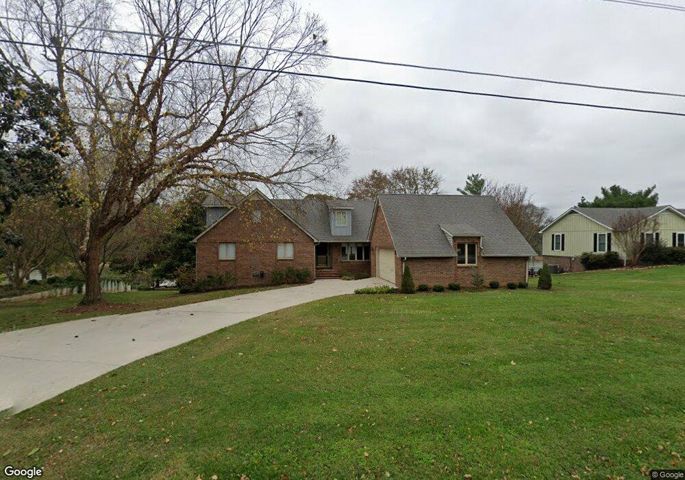
121 Brandi Way Winchester, TN 37398
Estimated Value: $811,000 - $1,123,387
--
Bed
3
Baths
2,912
Sq Ft
$328/Sq Ft
Est. Value
About This Home
This home is located at 121 Brandi Way, Winchester, TN 37398 and is currently estimated at $955,347, approximately $328 per square foot. 121 Brandi Way is a home located in Franklin County with nearby schools including North Middle School, Franklin County High School, and Winchester Christian Academy.
Ownership History
Date
Name
Owned For
Owner Type
Purchase Details
Closed on
Jun 3, 2020
Sold by
Ralston Scott A and Adine M Ralston Living Trust
Bought by
Graham Richard and Graham Elizabeth
Current Estimated Value
Purchase Details
Closed on
Apr 26, 1999
Sold by
Dubois Willie Lee
Bought by
Ralston Adine M Living Trf
Purchase Details
Closed on
Aug 1, 1990
Bought by
Dubois Willie Lee and Amy Lee
Purchase Details
Closed on
Mar 21, 1989
Bought by
Dotson Leonard H and Dotson Joann
Purchase Details
Closed on
Mar 19, 1986
Purchase Details
Closed on
Aug 12, 1985
Purchase Details
Closed on
Sep 6, 1983
Create a Home Valuation Report for This Property
The Home Valuation Report is an in-depth analysis detailing your home's value as well as a comparison with similar homes in the area
Home Values in the Area
Average Home Value in this Area
Purchase History
| Date | Buyer | Sale Price | Title Company |
|---|---|---|---|
| Graham Richard | $480,000 | Southern Tennessee T&E Llc | |
| Ralston Adine M Living Trf | $232,000 | -- | |
| Dubois Willie Lee | $26,300 | -- | |
| Dotson Leonard H | $16,500 | -- | |
| -- | $19,500 | -- | |
| -- | -- | -- | |
| -- | -- | -- |
Source: Public Records
Tax History Compared to Growth
Tax History
| Year | Tax Paid | Tax Assessment Tax Assessment Total Assessment is a certain percentage of the fair market value that is determined by local assessors to be the total taxable value of land and additions on the property. | Land | Improvement |
|---|---|---|---|---|
| 2024 | $5,757 | $223,925 | $100,000 | $123,925 |
| 2023 | $5,757 | $223,925 | $100,000 | $123,925 |
| 2022 | $5,645 | $223,925 | $100,000 | $123,925 |
| 2021 | $3,037 | $223,925 | $100,000 | $123,925 |
| 2020 | $3,548 | $100,400 | $55,000 | $45,400 |
| 2019 | $3,548 | $100,400 | $55,000 | $45,400 |
| 2018 | $3,343 | $100,400 | $55,000 | $45,400 |
| 2017 | $3,343 | $100,400 | $55,000 | $45,400 |
| 2016 | $3,222 | $96,750 | $55,000 | $41,750 |
| 2015 | $3,162 | $96,750 | $55,000 | $41,750 |
| 2014 | $3,162 | $96,755 | $0 | $0 |
Source: Public Records
Map
Nearby Homes
- 103 Lisa Cir
- 0 Spring Hill Dr
- 510 N Porter St
- 0 N Porter St
- 303 N Porter St
- 203 3rd Ave NE
- 1108 N Jefferson St
- 201&203 3rd Ave NE
- 311 N Jefferson St
- 715 N High St
- 706 N Vine St
- 74 Summerlake Ct
- 0 Summerlake Ct Unit RTC2936678
- 0 Summerlake Ct Unit RTC2936679
- 0 Summerlake Ct Unit RTC2936676
- 0 Summerlake Ct Unit RTC2936675
- 0 Summerlake Ct Unit RTC2936677
- 0 Summerlake Ct Unit RTC2936673
- 0 Summerlake Ct Unit RTC2936674
- 906 N High St