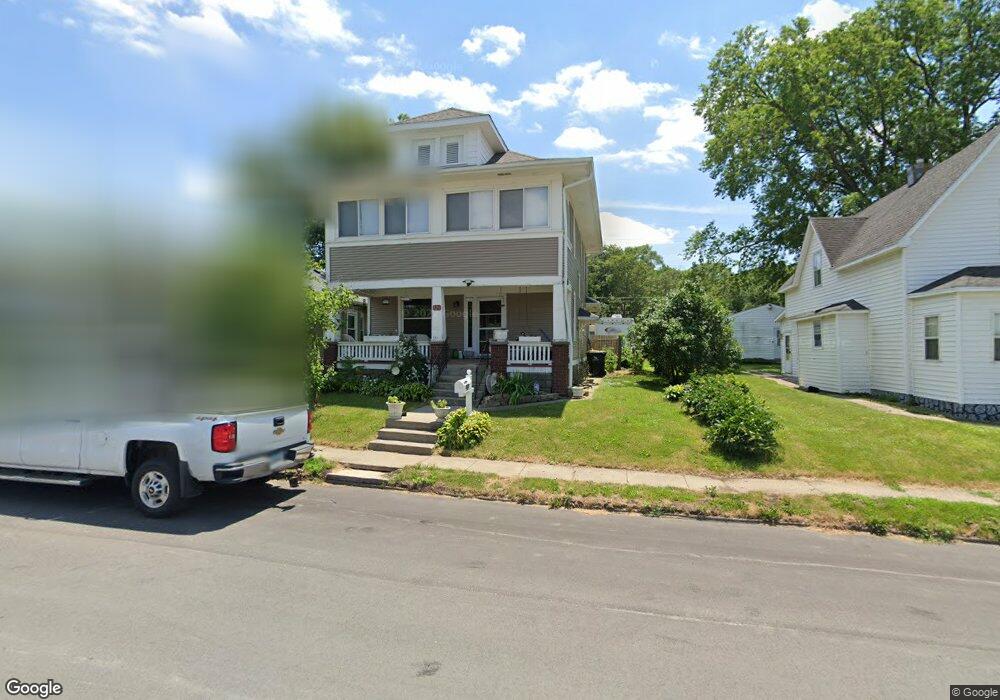
121 E Front St Colfax, IA 50054
Estimated Value: $166,000 - $254,000
4
Beds
2
Baths
1,584
Sq Ft
$122/Sq Ft
Est. Value
About This Home
This home is located at 121 E Front St, Colfax, IA 50054 and is currently estimated at $193,614, approximately $122 per square foot. 121 E Front St is a home with nearby schools including Colfax-Mingo Elementary School and Colfax-Mingo High School.
Ownership History
Date
Name
Owned For
Owner Type
Purchase Details
Closed on
Dec 27, 2012
Sold by
Doak Kenneth L and Doak Sondra L
Bought by
Blom Darrin B and Blom Margaret E
Current Estimated Value
Home Financials for this Owner
Home Financials are based on the most recent Mortgage that was taken out on this home.
Original Mortgage
$66,788
Interest Rate
3.28%
Mortgage Type
New Conventional
Purchase Details
Closed on
Feb 1, 2008
Sold by
Deutsche Bank National Trust Co
Bought by
Doak Kenneth L and Doak Sondra L
Home Financials for this Owner
Home Financials are based on the most recent Mortgage that was taken out on this home.
Original Mortgage
$76,000
Interest Rate
5.75%
Mortgage Type
Purchase Money Mortgage
Create a Home Valuation Report for This Property
The Home Valuation Report is an in-depth analysis detailing your home's value as well as a comparison with similar homes in the area
Purchase History
| Date | Buyer | Sale Price | Title Company |
|---|---|---|---|
| Blom Darrin B | $83,500 | None Available | |
| Doak Kenneth L | $65,000 | Title Services Corporation |
Source: Public Records
Mortgage History
| Date | Status | Borrower | Loan Amount |
|---|---|---|---|
| Closed | Blom Darrin B | $66,788 | |
| Previous Owner | Doak Kenneth L | $76,000 |
Source: Public Records
Tax History
| Year | Tax Paid | Tax Assessment Tax Assessment Total Assessment is a certain percentage of the fair market value that is determined by local assessors to be the total taxable value of land and additions on the property. | Land | Improvement |
|---|---|---|---|---|
| 2025 | $2,192 | $150,820 | $8,730 | $142,090 |
| 2024 | $2,192 | $133,820 | $8,730 | $125,090 |
| 2023 | $2,200 | $133,820 | $8,730 | $125,090 |
| 2022 | $1,996 | $107,100 | $8,730 | $98,370 |
| 2021 | $2,024 | $101,270 | $8,730 | $92,540 |
| 2020 | $2,024 | $96,710 | $6,110 | $90,600 |
| 2019 | $1,798 | $83,070 | $0 | $0 |
| 2018 | $1,798 | $83,070 | $0 | $0 |
| 2017 | $1,774 | $83,070 | $0 | $0 |
| 2016 | $1,774 | $83,070 | $0 | $0 |
| 2015 | $1,756 | $83,070 | $0 | $0 |
| 2014 | $1,672 | $83,070 | $0 | $0 |
Source: Public Records
Map
Nearby Homes
- 200 Jefferson St
- 300 E Front St
- 205 E Division St
- 108 S Walnut St
- 222 E Broadway St
- 110 W Broadway St
- 238 S Walnut St
- 226 S Iowa St
- 214 S Lincoln St
- 221 Cherry St
- 215 W Spring St
- 000 College Ave
- 655 E Division St
- 501 W Broadway St
- 17 S Kelly St
- 400 S Goodrich St
- 10114 S 34th Ave W
- 1132 S Goodrich St
- 1161 S Goodrich St
- 11213 Orchard Ave
- 125 E Front St
- 117 E Front St
- 129 E Front St
- 109 E Front St
- 111 N Maple St
- 105 E Front St
- 116 N Elm St
- 203 E Front St
- 112 N Elm St
- 110 N Maple St
- 202 E Front St
- 100 E Howard St
- 210 E Front St
- 217 E Front St
- 217 E Front St
- 217 E Front St Unit B
- 217 E Front St Unit A
- 217 E Front St Unit A
- 115 E Howard St
- 125 E Howard St
Your Personal Tour Guide
Ask me questions while you tour the home.