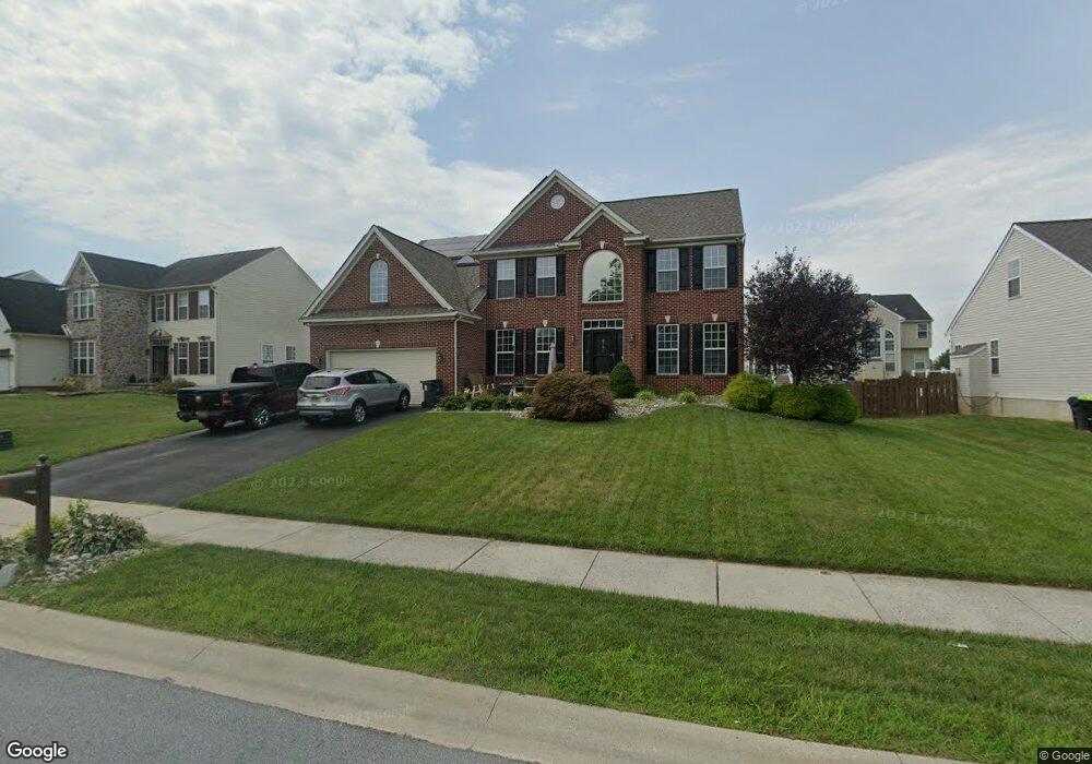
121 Edgar Rd Townsend, DE 19734
Estimated Value: $451,000 - $571,000
4
Beds
3
Baths
2,875
Sq Ft
$184/Sq Ft
Est. Value
About This Home
This home is located at 121 Edgar Rd, Townsend, DE 19734 and is currently estimated at $529,387, approximately $184 per square foot. 121 Edgar Rd is a home located in New Castle County with nearby schools including Townsend Elementary School, Everett Meredith Middle School, and Odessa High School.
Ownership History
Date
Name
Owned For
Owner Type
Purchase Details
Closed on
Aug 5, 2009
Sold by
Glasco Kevin L
Bought by
Harris Michael G and Harris Sonnia L
Current Estimated Value
Home Financials for this Owner
Home Financials are based on the most recent Mortgage that was taken out on this home.
Original Mortgage
$304,700
Outstanding Balance
$198,463
Interest Rate
5.19%
Mortgage Type
VA
Estimated Equity
$330,924
Purchase Details
Closed on
Jan 10, 2006
Sold by
Townsend Properties Llc
Bought by
Glasco Kevin L
Home Financials for this Owner
Home Financials are based on the most recent Mortgage that was taken out on this home.
Original Mortgage
$252,229
Interest Rate
5.75%
Mortgage Type
Fannie Mae Freddie Mac
Create a Home Valuation Report for This Property
The Home Valuation Report is an in-depth analysis detailing your home's value as well as a comparison with similar homes in the area
Home Values in the Area
Average Home Value in this Area
Purchase History
| Date | Buyer | Sale Price | Title Company |
|---|---|---|---|
| Harris Michael G | $295,000 | Lawyers Title Insurance Corp | |
| Glasco Kevin L | $384,243 | None Available |
Source: Public Records
Mortgage History
| Date | Status | Borrower | Loan Amount |
|---|---|---|---|
| Open | Harris Michael G | $304,700 | |
| Previous Owner | Glasco Kevin L | $252,229 |
Source: Public Records
Tax History
| Year | Tax Paid | Tax Assessment Tax Assessment Total Assessment is a certain percentage of the fair market value that is determined by local assessors to be the total taxable value of land and additions on the property. | Land | Improvement |
|---|---|---|---|---|
| 2024 | $223 | $106,100 | $11,900 | $94,200 |
| 2023 | $3,290 | $106,100 | $11,900 | $94,200 |
| 2022 | $3,285 | $106,100 | $11,900 | $94,200 |
| 2021 | $3,245 | $106,100 | $11,900 | $94,200 |
| 2020 | $3,206 | $106,100 | $11,900 | $94,200 |
| 2019 | $3,338 | $106,100 | $11,900 | $94,200 |
| 2018 | $2,920 | $106,100 | $11,900 | $94,200 |
| 2017 | $2,807 | $106,100 | $11,900 | $94,200 |
| 2016 | $2,534 | $106,100 | $11,900 | $94,200 |
| 2015 | $2,454 | $106,100 | $11,900 | $94,200 |
| 2014 | $2,448 | $106,100 | $11,900 | $94,200 |
Source: Public Records
Map
Nearby Homes
- 735 Tracy Cir
- 412 Main St
- 308 Gray St
- 3 Barcus Ct
- 306 Lattomus St
- 216 Edgar Rd
- 631 Commerce St
- 100 Karins Blvd
- 422 Bellflower Way Unit CHALFONT PLAN
- 420 Bellflower Way Unit MERION PLAN
- 418 Bellflower Way Unit MONTCHANIN PLAN
- 416 Bellflower Way Unit PENNSBURY PLAN
- 342 Coralroot Dr
- 341 Coralroot Dr
- 112 Hidden Creek Blvd
- 404 Wiggins Mill Rd
- 6147 Summit Bridge Rd
- 0 Lot 6 Ratledge Rd
- 102 Green Giant Rd
- 109 New Discovery Rd
Your Personal Tour Guide
Ask me questions while you tour the home.