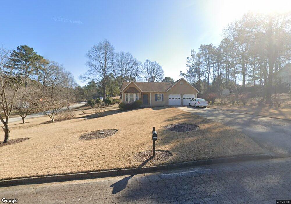
121 Farmbrook Trail Stockbridge, GA 30281
Estimated Value: $214,780 - $242,000
3
Beds
2
Baths
1,468
Sq Ft
$154/Sq Ft
Est. Value
About This Home
This home is located at 121 Farmbrook Trail, Stockbridge, GA 30281 and is currently estimated at $226,695, approximately $154 per square foot. 121 Farmbrook Trail is a home located in Henry County with nearby schools including Austin Road Elementary School, Austin Road Middle School, and Woodland High School.
Ownership History
Date
Name
Owned For
Owner Type
Purchase Details
Closed on
Dec 21, 2003
Sold by
Dunaway Charles D
Bought by
Dunaway Frances E
Current Estimated Value
Purchase Details
Closed on
Dec 12, 2001
Sold by
Dunaway Charles D
Bought by
Dunaway Frances E
Home Financials for this Owner
Home Financials are based on the most recent Mortgage that was taken out on this home.
Original Mortgage
$58,500
Interest Rate
6.72%
Mortgage Type
New Conventional
Create a Home Valuation Report for This Property
The Home Valuation Report is an in-depth analysis detailing your home's value as well as a comparison with similar homes in the area
Home Values in the Area
Average Home Value in this Area
Purchase History
| Date | Buyer | Sale Price | Title Company |
|---|---|---|---|
| Dunaway Frances E | -- | -- | |
| Dunaway Frances E | -- | -- |
Source: Public Records
Mortgage History
| Date | Status | Borrower | Loan Amount |
|---|---|---|---|
| Previous Owner | Dunaway Frances E | $58,500 |
Source: Public Records
Tax History
| Year | Tax Paid | Tax Assessment Tax Assessment Total Assessment is a certain percentage of the fair market value that is determined by local assessors to be the total taxable value of land and additions on the property. | Land | Improvement |
|---|---|---|---|---|
| 2025 | $510 | $86,800 | $12,000 | $74,800 |
| 2024 | $510 | $96,960 | $12,000 | $84,960 |
| 2023 | $296 | $82,800 | $10,000 | $72,800 |
| 2022 | $431 | $69,160 | $10,000 | $59,160 |
| 2021 | $1,314 | $56,080 | $10,000 | $46,080 |
| 2020 | $1,145 | $48,960 | $8,000 | $40,960 |
| 2019 | $1,083 | $46,320 | $8,000 | $38,320 |
| 2018 | $1,384 | $42,440 | $8,000 | $34,440 |
| 2016 | $1,073 | $34,000 | $6,000 | $28,000 |
| 2015 | $873 | $28,360 | $6,000 | $22,360 |
| 2014 | $834 | $27,200 | $4,800 | $22,400 |
Source: Public Records
Map
Nearby Homes
- 122 Farmbrook Trail
- 120 Farmbrook Trail
- 225 Farmbrook Pkwy
- 217 Farmbrook Pkwy Unit 2
- 226 Farmbrook Pkwy
- 232 Farmbrook Pkwy
- 200 Johns Creek Ln
- 194 Johns Creek Ln
- 203 Farmbrook Pkwy
- 1411 Fairview Rd
- 780 Gardner Rd
- 128 Crown Glen Way
- 60 Melanie Dr
- 437 Branch Forest Way
- 112 Fairview Dr
- 107 Parkview Dr
- 861 Gardner Rd
- 127 Fairview Way Unit 1
- 136 Hanes Creek Dr
- 1160 Fairview Rd
- 123 Farmbrook Trail Unit 1
- 220 Farmbrook Pkwy
- 119 Farmbrook Trail Unit 1
- 218 Farmbrook Pkwy
- 125 Farmbrook Trail
- 125 Farmbrook Trail Unit 1
- 124 Farmbrook Trail
- 117 Farmbrook Trail
- 117 Farmbrook Trail
- 221 Farmbrook Pkwy Unit 3
- 219 Farmbrook Pkwy Unit 2
- 223 Farmbrook Pkwy
- 224 Farmbrook Pkwy
- 126 Farmbrook Trail
- 127 Farmbrook Trail
- 116 Farmbrook Trail Unit 1
- 115 Farmbrook Trail
- 115 Farmbrook Trail
- 214 Farmbrook Pkwy
- 128 Farmbrook Trail
Your Personal Tour Guide
Ask me questions while you tour the home.