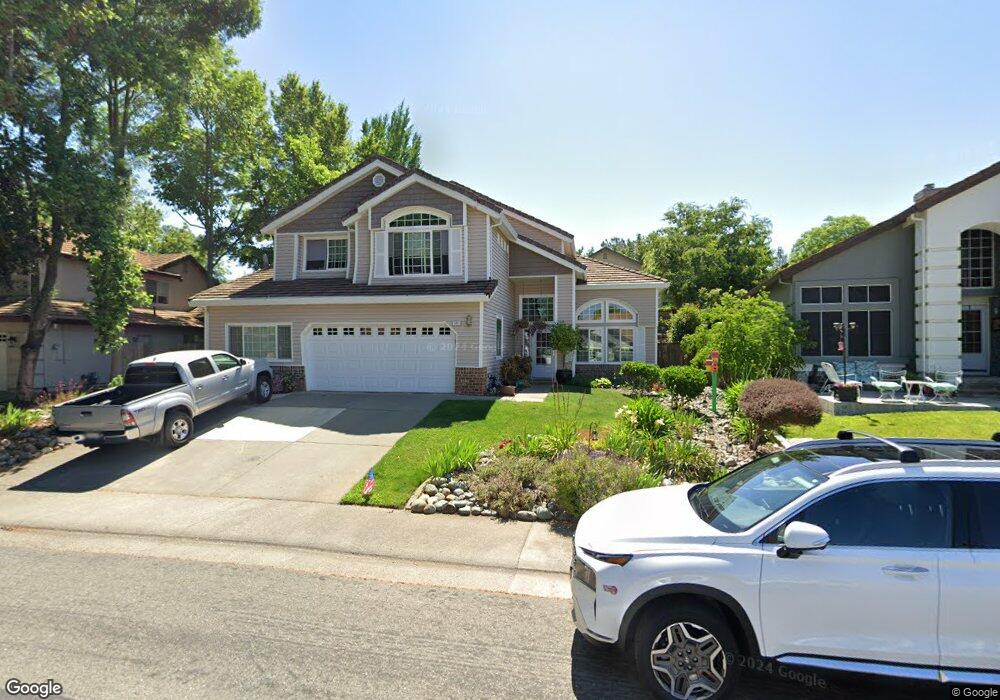
121 Kennar Way Folsom, CA 95630
Natoma Station NeighborhoodEstimated Value: $797,738 - $896,000
5
Beds
3
Baths
2,965
Sq Ft
$279/Sq Ft
Est. Value
About This Home
This home is located at 121 Kennar Way, Folsom, CA 95630 and is currently estimated at $826,435, approximately $278 per square foot. 121 Kennar Way is a home located in Sacramento County with nearby schools including Natoma Station Elementary School, Sutter Middle School, and Folsom High School.
Ownership History
Date
Name
Owned For
Owner Type
Purchase Details
Closed on
Feb 27, 2003
Sold by
Lunceford David L and Lunceford Sandra L
Bought by
Lunceford David L and Lunceford Sandra L
Current Estimated Value
Purchase Details
Closed on
May 20, 1996
Sold by
Tamm Edward A and Tamm Karin A
Bought by
Lunceford David L and Lunceford Sandra L
Home Financials for this Owner
Home Financials are based on the most recent Mortgage that was taken out on this home.
Original Mortgage
$160,000
Outstanding Balance
$9,092
Interest Rate
7.97%
Estimated Equity
$817,343
Create a Home Valuation Report for This Property
The Home Valuation Report is an in-depth analysis detailing your home's value as well as a comparison with similar homes in the area
Home Values in the Area
Average Home Value in this Area
Purchase History
| Date | Buyer | Sale Price | Title Company |
|---|---|---|---|
| Lunceford David L | -- | -- | |
| Lunceford David L | $240,000 | Old Republic Title Company |
Source: Public Records
Mortgage History
| Date | Status | Borrower | Loan Amount |
|---|---|---|---|
| Open | Lunceford David L | $160,000 |
Source: Public Records
Tax History
| Year | Tax Paid | Tax Assessment Tax Assessment Total Assessment is a certain percentage of the fair market value that is determined by local assessors to be the total taxable value of land and additions on the property. | Land | Improvement |
|---|---|---|---|---|
| 2025 | $4,447 | $414,879 | $107,967 | $306,912 |
| 2024 | $4,447 | $406,745 | $105,850 | $300,895 |
| 2023 | $4,369 | $398,771 | $103,775 | $294,996 |
| 2022 | $4,305 | $390,953 | $101,741 | $289,212 |
| 2021 | $4,247 | $383,289 | $99,747 | $283,542 |
| 2020 | $4,195 | $379,360 | $98,725 | $280,635 |
| 2019 | $4,126 | $371,923 | $96,790 | $275,133 |
| 2018 | $4,405 | $364,632 | $94,893 | $269,739 |
| 2017 | $4,163 | $357,483 | $93,033 | $264,450 |
| 2016 | $4,325 | $350,474 | $91,209 | $259,265 |
| 2015 | $4,352 | $345,210 | $89,839 | $255,371 |
| 2014 | $4,162 | $338,449 | $88,080 | $250,369 |
Source: Public Records
Map
Nearby Homes
- 112 Demurrage Way
- 145 Hopfield Dr
- 187 John Henry Cir
- 120 Elkins Cir
- 113 Ballast Way
- 107 Fantages Way
- 382 Seaton Dr
- 157 Sutcliffe Cir
- 321 Baird Dr
- 1109 Sandy Creek Dr
- 133 Brightstone Cir
- 683 Loomis Cir
- 656 Silo St
- 301 Blossom Rock Ln Unit 53
- 682 Diamond Glen Cir
- 894 Blossom Rock Ln
- 931 Willow Bridge Dr
- 448 Gem Smith Place
- 114 Barnhill Dr
- 701 Ferrier Way
- 123 Kennar Way
- 119 Kennar Way
- 165 Bayline Cir
- 167 Bayline Cir
- 163 Bayline Cir
- 117 Kennar Way
- 125 Kennar Way
- 169 Bayline Cir
- 116 Kennar Way
- 114 Kennar Way
- 161 Bayline Cir
- 118 Kennar Way
- 171 Bayline Cir
- 112 Kennar Way
- 115 Kennar Way
- 127 Kennar Way
- 157 Bayline Cir
- 120 Kennar Way
- 173 Bayline Cir
- 110 Kennar Way
Your Personal Tour Guide
Ask me questions while you tour the home.