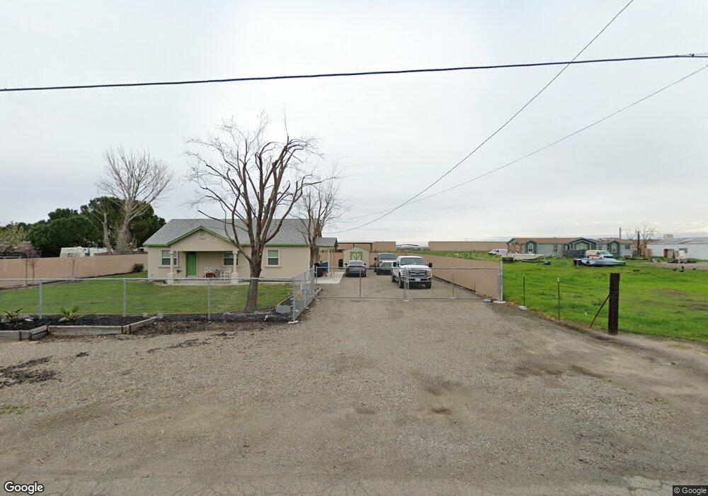
121 Klo Rd Lathrop, CA 95330
Estimated Value: $362,000 - $1,424,000
2
Beds
1
Bath
1,040
Sq Ft
$652/Sq Ft
Est. Value
About This Home
This home is located at 121 Klo Rd, Lathrop, CA 95330 and is currently estimated at $677,635, approximately $651 per square foot. 121 Klo Rd is a home located in San Joaquin County with nearby schools including Joseph Widmer, Jr. Elementary School, Lathrop High School, and Central Valley Christian Academy.
Ownership History
Date
Name
Owned For
Owner Type
Purchase Details
Closed on
Dec 14, 2004
Sold by
Gigli Donald
Bought by
Giglico Inc
Current Estimated Value
Purchase Details
Closed on
Aug 9, 1996
Sold by
Hayres Egg Farms
Bought by
Gigli Donald and Gigli Dianne
Home Financials for this Owner
Home Financials are based on the most recent Mortgage that was taken out on this home.
Original Mortgage
$88,000
Interest Rate
8.18%
Create a Home Valuation Report for This Property
The Home Valuation Report is an in-depth analysis detailing your home's value as well as a comparison with similar homes in the area
Purchase History
| Date | Buyer | Sale Price | Title Company |
|---|---|---|---|
| Giglico Inc | -- | -- | |
| Gigli Donald | $110,000 | Old Republic Title Company |
Source: Public Records
Mortgage History
| Date | Status | Borrower | Loan Amount |
|---|---|---|---|
| Previous Owner | Gigli Donald | $88,000 |
Source: Public Records
Tax History
| Year | Tax Paid | Tax Assessment Tax Assessment Total Assessment is a certain percentage of the fair market value that is determined by local assessors to be the total taxable value of land and additions on the property. | Land | Improvement |
|---|---|---|---|---|
| 2025 | $2,269 | $179,136 | $89,568 | $89,568 |
| 2024 | $2,210 | $175,624 | $87,812 | $87,812 |
| 2023 | $2,096 | $172,182 | $86,091 | $86,091 |
| 2022 | $2,067 | $168,806 | $84,403 | $84,403 |
| 2021 | $2,047 | $165,498 | $82,749 | $82,749 |
| 2020 | $1,971 | $163,802 | $81,901 | $81,901 |
| 2019 | $1,948 | $160,592 | $80,296 | $80,296 |
| 2018 | $1,924 | $157,444 | $78,722 | $78,722 |
| 2017 | $1,899 | $154,358 | $77,179 | $77,179 |
| 2016 | $1,857 | $151,332 | $75,666 | $75,666 |
| 2014 | $1,734 | $146,140 | $73,070 | $73,070 |
Source: Public Records
Map
Nearby Homes
- 272 Olivine Ave
- 13410 Brookwood Way
- 174 Castlewood Ave
- 960 Kirkwood Way
- 14061 Jasper St
- 14129 Reverend Maurice Cotton Dr
- 795 Saint Andrew St
- 827 Saint Andrew St
- 14224 S Harlan Rd
- 774 Sugar Pine Dr
- 813 Sugar Pine Dr
- 10878 S Mckinley Ave
- 14539 Cedar Valley Dr
- 808 Prairie Dunes Dr
- 292 W Lathrop Rd
- 15150 Hollyhock Ct
- 10016 S Priest Rd
- 407 Sacramento St
- 879 Osprey Dr
- 15820 S Harlan Rd Unit 85
Your Personal Tour Guide
Ask me questions while you tour the home.