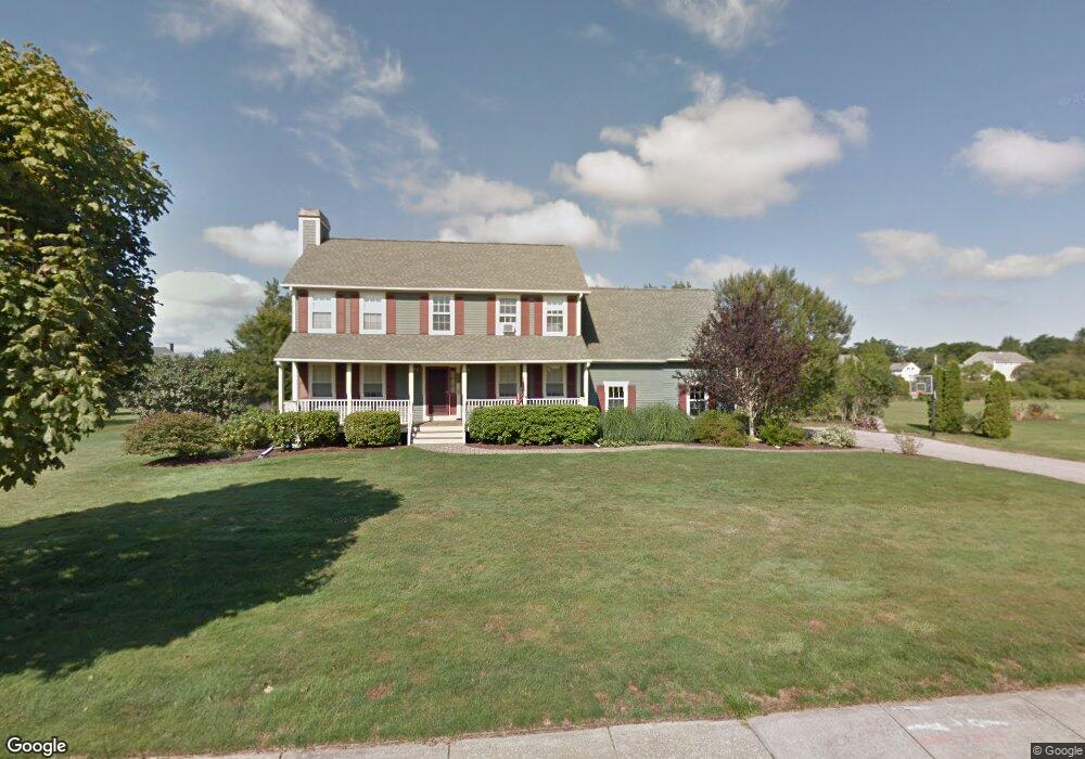
121 Lighthouse View Dr Middletown, RI 02842
Estimated Value: $1,023,503 - $1,320,000
4
Beds
3
Baths
2,300
Sq Ft
$536/Sq Ft
Est. Value
About This Home
This home is located at 121 Lighthouse View Dr, Middletown, RI 02842 and is currently estimated at $1,233,626, approximately $536 per square foot. 121 Lighthouse View Dr is a home located in Newport County with nearby schools including Middletown High School, St Michael's Country Day School, and St George's School.
Ownership History
Date
Name
Owned For
Owner Type
Purchase Details
Closed on
May 30, 2003
Sold by
Hills Helen
Bought by
Oard Ronald and Oard Kelly
Current Estimated Value
Home Financials for this Owner
Home Financials are based on the most recent Mortgage that was taken out on this home.
Original Mortgage
$322,000
Interest Rate
5.86%
Mortgage Type
Purchase Money Mortgage
Purchase Details
Closed on
Jan 29, 1999
Sold by
Ocean Ridge Dev
Bought by
Hills Norman A and Hills Helen
Create a Home Valuation Report for This Property
The Home Valuation Report is an in-depth analysis detailing your home's value as well as a comparison with similar homes in the area
Home Values in the Area
Average Home Value in this Area
Purchase History
| Date | Buyer | Sale Price | Title Company |
|---|---|---|---|
| Oard Ronald | $471,500 | -- | |
| Hills Norman A | $240,000 | -- |
Source: Public Records
Mortgage History
| Date | Status | Borrower | Loan Amount |
|---|---|---|---|
| Open | Hills Norman A | $304,200 | |
| Closed | Hills Norman A | $336,000 | |
| Closed | Hills Norman A | $85,000 | |
| Closed | Hills Norman A | $322,000 |
Source: Public Records
Tax History Compared to Growth
Tax History
| Year | Tax Paid | Tax Assessment Tax Assessment Total Assessment is a certain percentage of the fair market value that is determined by local assessors to be the total taxable value of land and additions on the property. | Land | Improvement |
|---|---|---|---|---|
| 2025 | $10,064 | $853,600 | $406,200 | $447,400 |
| 2024 | $9,612 | $853,600 | $406,200 | $447,400 |
| 2023 | $7,444 | $591,300 | $288,000 | $303,300 |
| 2022 | $7,107 | $591,300 | $288,000 | $303,300 |
| 2021 | $7,107 | $591,300 | $288,000 | $303,300 |
| 2020 | $6,861 | $498,600 | $235,400 | $263,200 |
| 2018 | $6,856 | $498,600 | $235,400 | $263,200 |
| 2016 | $7,698 | $499,200 | $239,500 | $259,700 |
| 2015 | $7,508 | $499,200 | $239,500 | $259,700 |
| 2014 | $7,731 | $481,100 | $218,500 | $262,600 |
| 2013 | $7,558 | $481,100 | $218,500 | $262,600 |
Source: Public Records
Map
Nearby Homes
- 0 Wolcott Ave
- 0 Honeyman Ave
- 476 Green End Ave
- 202 Reservoir Rd
- 318 Corey Ln
- 310 Corey Ln
- 118 Wolcott Ave
- 119 Corey Ln
- 55 John Clarke Rd Unit 8
- 55 John Clarke Rd Unit 3
- 980 Green End Ave
- 16 Sachuest Dr
- 223 Corey Ln
- 65 Seascape Ave
- 0 Saltwood Dr
- 162 Center Ave
- 141 Gray Craig Rd
- 84 Allston Ave
- 138 Green End Ave
- 36 Kay Blvd
- 121 Lighthouse Dr
- 135 Lighthouse Dr
- 101 Lighthouse View Dr
- 101 Lighthouse Dr
- 135 Lighthouse View Dr
- 156 Morrison Ave
- 140 Morrison Ave
- 130 Lighthouse View Dr
- 130 Lighthouse Dr
- 106 Lighthouse View Dr
- 106 Lighthouse Dr
- 375 Compton View Dr
- 85 Lighthouse View Dr
- 122 Morrison Ave
- 351 Compton View Dr
- 156 Lighthouse Dr
- 156 Lighthouse View Dr
- 241 Compton View Dr
- 261 Compton View Dr
- 80 Lighthouse Dr