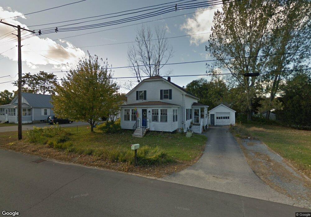
121 Maple St Somersworth, NH 03878
Estimated Value: $389,000 - $429,000
4
Beds
1
Bath
1,377
Sq Ft
$297/Sq Ft
Est. Value
About This Home
This home is located at 121 Maple St, Somersworth, NH 03878 and is currently estimated at $409,570, approximately $297 per square foot. 121 Maple St is a home located in Strafford County with nearby schools including Maple Wood Elementary School, Somersworth High School, and Tri-City Christian Academy.
Ownership History
Date
Name
Owned For
Owner Type
Purchase Details
Closed on
Apr 11, 2012
Sold by
Malone Jeanette J and Malone Marshall H
Bought by
Raynes Katie L and Gogan Rachel C
Current Estimated Value
Purchase Details
Closed on
Jan 10, 1997
Sold by
Davidson Gregory E and Davidson Colleen L
Bought by
Malone Marshall H and Malone Jeanette J
Home Financials for this Owner
Home Financials are based on the most recent Mortgage that was taken out on this home.
Original Mortgage
$83,300
Interest Rate
7.46%
Create a Home Valuation Report for This Property
The Home Valuation Report is an in-depth analysis detailing your home's value as well as a comparison with similar homes in the area
Home Values in the Area
Average Home Value in this Area
Purchase History
| Date | Buyer | Sale Price | Title Company |
|---|---|---|---|
| Raynes Katie L | $131,500 | -- | |
| Raynes Katie L | $131,500 | -- | |
| Malone Marshall H | $83,300 | -- | |
| Malone Marshall H | $83,300 | -- |
Source: Public Records
Mortgage History
| Date | Status | Borrower | Loan Amount |
|---|---|---|---|
| Previous Owner | Malone Marshall H | $83,300 | |
| Closed | Malone Marshall H | $0 |
Source: Public Records
Tax History Compared to Growth
Tax History
| Year | Tax Paid | Tax Assessment Tax Assessment Total Assessment is a certain percentage of the fair market value that is determined by local assessors to be the total taxable value of land and additions on the property. | Land | Improvement |
|---|---|---|---|---|
| 2024 | $6,796 | $363,400 | $100,800 | $262,600 |
| 2023 | $6,323 | $215,800 | $50,400 | $165,400 |
| 2022 | $6,062 | $215,800 | $50,400 | $165,400 |
| 2021 | $5,613 | $203,900 | $50,400 | $153,500 |
| 2020 | $5,679 | $203,900 | $50,400 | $153,500 |
| 2019 | $5,562 | $203,900 | $50,400 | $153,500 |
| 2018 | $5,356 | $160,300 | $59,500 | $100,800 |
| 2017 | $5,185 | $156,700 | $59,500 | $97,200 |
| 2016 | $5,033 | $156,700 | $59,500 | $97,200 |
| 2015 | $5,054 | $156,700 | $59,500 | $97,200 |
| 2014 | $4,880 | $156,700 | $59,500 | $97,200 |
Source: Public Records
Map
Nearby Homes
- 29 Chadwick Ln
- 18 Lenox Dr Unit C
- 19B Birch Hill Ln Unit 19B
- 23A Birch Hill Ln Unit 23A
- 23B Birch Hill Ln Unit 23B
- 43 Otis Rd
- 159 W High St
- 22A Birch Hill Ln Unit 22A
- 22B Birch Hill Ln Unit 22B
- 19A Birch Hill Ln Unit 19A
- 27B Birch Hill Ln Unit 27B
- 23 Mount Vernon St
- 178 High St
- 18 Grand St
- 24-26 Highland St
- 11 Linden St
- 25 High St
- 8 Myrtle St
- 1 Bridge St
- 105-107 Main St