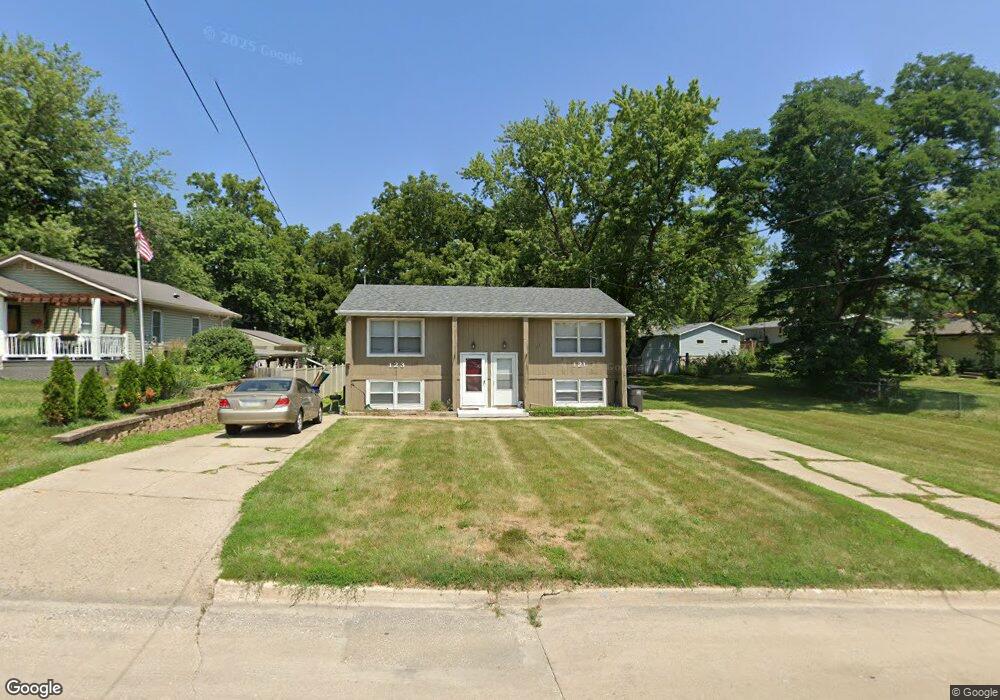
121 Philip St Des Moines, IA 50315
Watrous Heights NeighborhoodEstimated Value: $201,906 - $247,000
4
Beds
2
Baths
1,008
Sq Ft
$229/Sq Ft
Est. Value
About This Home
This home is located at 121 Philip St, Des Moines, IA 50315 and is currently estimated at $231,227, approximately $229 per square foot. 121 Philip St is a home located in Polk County with nearby schools including South Union Elementary School, Brody Middle School, and Lincoln High School.
Ownership History
Date
Name
Owned For
Owner Type
Purchase Details
Closed on
Nov 6, 2023
Sold by
Porter Kelsey Anne
Bought by
Porter Kelsey Anne and Whitley Carson M
Current Estimated Value
Purchase Details
Closed on
Apr 25, 2023
Sold by
Rockin C Properties Llc
Bought by
Porter Kelsey Anne
Home Financials for this Owner
Home Financials are based on the most recent Mortgage that was taken out on this home.
Original Mortgage
$209,000
Interest Rate
6.28%
Mortgage Type
New Conventional
Purchase Details
Closed on
Jan 25, 2022
Sold by
Christiansen Tyler J and Christiansen Nikki A
Bought by
Rockin C Properties Llc
Purchase Details
Closed on
Aug 5, 2021
Sold by
Mcgee Steven M and Mcgee Mark E
Bought by
Christiansen Tyler J and Christiansen Nikki A
Home Financials for this Owner
Home Financials are based on the most recent Mortgage that was taken out on this home.
Original Mortgage
$136,000
Interest Rate
2.9%
Mortgage Type
Future Advance Clause Open End Mortgage
Purchase Details
Closed on
Nov 14, 2006
Sold by
Us Bank Na
Bought by
Mcgee Steven M and Mcgee Mark E
Home Financials for this Owner
Home Financials are based on the most recent Mortgage that was taken out on this home.
Original Mortgage
$78,400
Interest Rate
6.27%
Mortgage Type
Purchase Money Mortgage
Purchase Details
Closed on
Aug 21, 2006
Sold by
Mortgage Electronic Registration Systems
Bought by
Us Bank Na
Purchase Details
Closed on
Jul 20, 2006
Sold by
Mccollum Michael
Bought by
Mortgage Electronic Registration Systems
Purchase Details
Closed on
Mar 25, 2005
Sold by
Simms Hoy Lee and Simms Marjorie D
Bought by
Mccollum Michael
Home Financials for this Owner
Home Financials are based on the most recent Mortgage that was taken out on this home.
Original Mortgage
$110,400
Interest Rate
6.95%
Create a Home Valuation Report for This Property
The Home Valuation Report is an in-depth analysis detailing your home's value as well as a comparison with similar homes in the area
Home Values in the Area
Average Home Value in this Area
Purchase History
| Date | Buyer | Sale Price | Title Company |
|---|---|---|---|
| Porter Kelsey Anne | -- | None Listed On Document | |
| Porter Kelsey Anne | -- | None Listed On Document | |
| Porter Kelsey Anne | $220,000 | None Listed On Document | |
| Porter Kelsey Anne | $220,000 | None Listed On Document | |
| Rockin C Properties Llc | -- | None Listed On Document | |
| Christiansen Tyler J | $170,000 | None Available | |
| Mcgee Steven M | $97,500 | Title Services Corporation | |
| Us Bank Na | -- | None Available | |
| Mortgage Electronic Registration Systems | $103,500 | None Available | |
| Mccollum Michael | $137,500 | -- |
Source: Public Records
Mortgage History
| Date | Status | Borrower | Loan Amount |
|---|---|---|---|
| Previous Owner | Porter Kelsey Anne | $209,000 | |
| Previous Owner | Christiansen Tyler J | $136,000 | |
| Previous Owner | Mcgee Steven M | $78,400 | |
| Previous Owner | Mccollum Michael | $110,400 |
Source: Public Records
Tax History Compared to Growth
Tax History
| Year | Tax Paid | Tax Assessment Tax Assessment Total Assessment is a certain percentage of the fair market value that is determined by local assessors to be the total taxable value of land and additions on the property. | Land | Improvement |
|---|---|---|---|---|
| 2025 | $3,564 | $220,600 | $38,000 | $182,600 |
| 2024 | $3,564 | $181,200 | $33,100 | $148,100 |
| 2023 | $3,360 | $181,200 | $33,100 | $148,100 |
| 2022 | $3,336 | $142,600 | $27,300 | $115,300 |
| 2021 | $3,352 | $142,600 | $27,300 | $115,300 |
| 2020 | $3,482 | $134,300 | $25,500 | $108,800 |
| 2019 | $3,212 | $134,300 | $25,500 | $108,800 |
| 2018 | $3,180 | $119,500 | $22,300 | $97,200 |
| 2017 | $3,054 | $119,500 | $22,300 | $97,200 |
| 2016 | $2,976 | $112,900 | $20,600 | $92,300 |
| 2015 | $2,976 | $112,900 | $20,600 | $92,300 |
| 2014 | $3,074 | $115,700 | $20,700 | $95,000 |
Source: Public Records
Map
Nearby Homes
- 108 E Philip St
- 102 E Emma Ave
- 126 E Maxwelton Dr
- 117 E Watrous Ave
- 209 E Philip St
- 115 Mckinley Ave
- 304 Herold Ave
- 515 Emma Ave
- 518 Maxwelton Dr
- 117 E Rose Ave
- 4316 SE 4th St
- 606 Marion St
- 311 E Emma Ave
- 612 Emma Ave
- 4204 SW 7th St
- 409 Wilmers Ave
- 212 Titus Ave
- 3634 SW 4th St
- 314 E Rose Ave
- 433 E Marion St
- 4312 South Union St
- 4306 South Union St
- 4312 S Union St
- 171 Philip St
- 201 Philip St
- 4401 SW 2nd St
- 108 Philip St
- 203 Philip St
- 4409 SW 2nd St
- 4202 South Union St
- 205 Philip St
- 4413 SW 2nd St
- 4412 South Union St
- 4400 SW 2nd St
- 4401 South Union St
- 4401 S Union St
- 207 Philip St
- 4404 SW 2nd St
- 4414 South Union St
- 4212 South Union St